OCC GOSHIP

The GO-SHIP/CO2 Repeat Hydrography Program

Analyzing Decadal Changes in the Ocean’s Circulation and Uptake of Anthropogenic CO2

SCROLL TO LEARN MORE

Dr. Rik Wanninkhof


The International Global Ocean Ship-based Hydrographic Investigations Program (www.go-ship.org) is a multi-disciplinary international program that occupies selected trans-basin sections on decadal timescales to document changes in heat, fresh water, carbon, nutrients, oxygen, and trace gases in the ocean. The work is executed in each major ocean basin by NOAA and NSF funded-investigators using NOAA and UNOLS vessels. Ship-based hydrography remains the only method for obtaining high-quality, high spatial, and vertical resolution measurements of a suite of physical, chemical, and biological parameters over the full water column. The foci are to quantify increases in anthropogenic carbon content and natural and climate induced changes in chemical and hydrographic features in the ocean to determine:

  • The distributions and controls of natural and anthropogenic carbon
  • Uncertainties in global fresh water, heat, and property budgets
  • Ocean ventilation and circulation pathways and rates using chemical tracers
  • The variability and controls in water mass properties and ventilation
  • The changes of a wide range of biogeochemically and ecologically important properties in the ocean interior

Major discoveries to date have been the accurate determining of heating of bottom water and a small increase of carbon in the deep ocean. The program has also quantified increases of CO2 in surface and intermediate water and its effect on ocean acidification. A key aspect of the program is the open and rapid dissemination of data for utilization by the community at large. Program details can be found at https://www.go-ship.org/ and datasets are available at: CLIVAR and Carbon Hydrographic Data Office (CCHDO) and Ocean Carbon and Acidification Data System (OCADS).

Plot of Caribbean Gridded and Mapped Data

A13.5 2024 GO-SHIP/CO2 Repeat Hydrography Cruise

Peviously occupied in 1983/84, 1995, and 2010, the 2024 February-April occupation will be the 4th repeat. The cruise departed Mindelo, Cape Verde on February 1, 2024 and arrived in Cape Town, South Africa on March 23, 2024. The cruise took place on the UNOLS ship R/V Marcus G. Langseth. The University-National Oceanographic Laboratory System (UNOLS) is a group of academic institutions and National Laboratories organized in the United States to coordinate research vessel use for federally funded ocean research.

Top News

Floating ice, freezing temperatures: Four facts about the I08S GO-SHIP cruise to Antarctica

Floating ice, freezing temperatures, and streaks of lights in the night sky. The I08S GO-SHIP cruise successfully concluded on April 1st.

The R/V Thomas Thompson at the dock in Fremantle, Australia benath the night sky with the glimmer of the moonlight trickling from above and the yellow lights of the ship beaming like stars stolen from the darkness above

Read More News

Two NOAA scientists deploy a large CTD into the ocean.
On May 9, a team of scientists aboard the NOAA Ship Ronald H. Brown arrived at their final destination in Reykjavik, Iceland following 55 days at sea. The team of 50 scientists and 28 crew members followed a track through the North Atlantic, from Brazil to Iceland, referred to as the A16N transect, and successfully completed 150 stations, collecting over 3,000 samples from the Atlantic’s surface to the seafloor, giving scientists a holistic snapshot of the Atlantic Ocean basin.
NOAA Ship Ronald H. Brown
NOAA Research Vessel “Ronald H. Brown” in the harbor of Victoria, Seychelles. Photo Credit: NOAA.
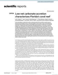
Front page of the featured scientific publication

John T. Morris, Ian C. Enochs, et al.

Coral reef habitat is created when calcium carbonate production by calcifiers exceeds removal by physical and biological erosion. Carbonate budget surveys provide a means of quantifying the framework-altering actions of diverse assemblages of marine species to determine net carbonate production, a single metric that encapsulates reef habitat persistence. In this study, carbonate budgets were calculated for 723 sites across the Florida Reef Tract (FRT) using benthic cover and parrot fish demographic data from NOAA’s National Coral Reef Monitoring Program, as well as high resolution LiDAR topobathymetry. Results highlight the erosional state of the majority of the study sites, with a trend towards more vulnerable habitat in the northern FRT, especially in the Southeast Florida region (− 0.51 kg CaCO3m−2 year−1), which is in close proximity to urban centers. Detailed comparison of reef types reveals that mid-channel reefs in the Florida Keys have the highest net carbonate production (0.84 kg CaCO3 m−2 year− 1) and indicates that these reefs may be hold-outs for reef development throughout the region. This study reports that Florida reefs, specifically their physical structure, are in a net erosional state. As these reefs lose structure, the ecosystem services they provide will be diminished, signifying the importance of increased protections and management efforts to offset these trends.

Download the full paper

Data & Logistics for AOML Led GO-SHIP Cruises

Partners