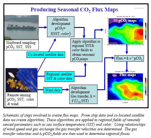
Creating Flux maps
The major goal of NOAA's Global Carbon Cycle Program (GCCP) is to quantify sources and sinks of carbon dioxide. One means of doing this is to determine the CO2 flux across the air-sea interface. The air-sea CO2 flux is defined as the products of the CO2 partial pressure difference across the air-sea interface and a quantity referred to as the gas transfer velocity that is often related to wind speed. Thus the air-sea CO 2 flux is defined as:
FCO2 = k ∆pCO2
Where ∆pCO2 is the partial pressure gradient between surface ocean and air.
The ∆pCO2 is measured as part of our program on research ships and volunteer observing ships (VOS). The challenge is to translate these ∆pCO2 observations, along a cruise line at a particular time, to a flux map that covers a region.
Our approach is to relate surface water partial pressure of CO2, pCO2sw to factors that control it and that are measured at greater frequency than our pCO2sw measurements. We then create algorithms between pCO2sw and these parameters. Fields of the parameters are created and from the algorithms we then create the regional pCO2sw fields. These fields are then combined with the gas transfer velocities to create the flux fields. The gas transfer velocities are determined from relationships of gas transfer with wind and the regional winds are determined from satellite observations,
The first choice of parameters to extrapolate the pCO2sw observations are those that can be observed from space in a synoptic fashion through remote sensing such as sea surface temperature and color. Other parameters that can be obtained at high resolution include those that are measured from VOS and floats. A schematic of the steps involved are shown in the figure below.
The work is funded through a grant "Ocean Carbon Watch: Improving Air-Sea CO2 Flux Estimates Through Remote Sensing" to Rik Wanninkhof, AOML; Richard Feely, PMEL; and Kent Hughes, NESDIS (National Environmental Satellite Data, and Information Service of NOAA) with as collaborators Joaquin Trinanes of CIMAS and Are Olsen of the University of Bergen. The initial objective is to use the data from the VOS line to create flux algorithms in the North Atlantic and North Pacific. We plan to work with international colleagues to accomplish this task.