IFEX daily log
Friday, July 22, 2005

On Friday the strong tropical wave remained in the extreme western Caribbean,
with convection east of the Yucatan Peninsula. The overall environment remained
favorable for development, with shear values around 10 kt and a distinct upper-level
anticyclone over the region (Fig. 19). Upper-level divergence was pronounced as well,
with values as large as 30 x 10-3 s-1 covering much of the area (Fig. 20). The National
Hurricane Center also began to identify this wave as a possible candidate for
development over the next several days. The only factor preventing development in the
 next 24-36 h was its proximity to land.
On the mesoscale, some of the convection within the wave showed pronounced
organization. For example, off the northern tip of the Yucatan a broad area of stratiform
and convective rainfall developed, with an east-west oriented line of strong convection at
2314 UTC 22 July (Fig. 21). This line of strong convection moved rapidly northward
next 24-36 h was its proximity to land.
On the mesoscale, some of the convection within the wave showed pronounced
organization. For example, off the northern tip of the Yucatan a broad area of stratiform
and convective rainfall developed, with an east-west oriented line of strong convection at
2314 UTC 22 July (Fig. 21). This line of strong convection moved rapidly northward
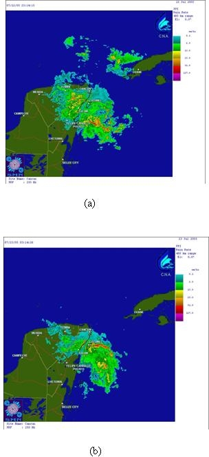 over the next 4 hours, leaving behind a trailing stratiform region that showed evidence of
rotation in the mid-levels.
The first flight into the system was scheduled to takeoff this evening at 00 UTC 23 July.
over the next 4 hours, leaving behind a trailing stratiform region that showed evidence of
rotation in the mid-levels.
The first flight into the system was scheduled to takeoff this evening at 00 UTC 23 July.
It was to be a mission coordinated with the ER-2. There was convection over the
Yucatan peninsula (cf. Fig. 21), but the P-3 would not be able to sample it because it did
not have overflight clearance for Mexico. There was also a north-northwest-south-
southeast oriented line of convection over the water east of the Yucatan that appeared to
persistently develop over the past 24 h. It was oriented along the eastern portion of what
was suspected to be the wave axis, and it seemed to regenerate every 12 h or so. The
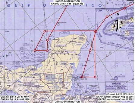 pattern called for a general survey pattern around the Yucatan (Fig. 22). There would be
coordination during much of this pattern, but especially in the convection over the water
east of the Yucatan. While much of the system appeared to be over land, it was hoped
that the system would move over water by the end of this mission, in time for the follow-
on daytime flight to sample it over water. It was not known where the center point of the
system was, or even if one existed. Models had started to develop a sea-level pressure
minimum east of south Belize and moving that toward the west-northwest, crossing the
Yucatan and entering the southern portion of the Bay of Campeche. If that were the case
the system would remain over land for a much longer period of time.
pattern called for a general survey pattern around the Yucatan (Fig. 22). There would be
coordination during much of this pattern, but especially in the convection over the water
east of the Yucatan. While much of the system appeared to be over land, it was hoped
that the system would move over water by the end of this mission, in time for the follow-
on daytime flight to sample it over water. It was not known where the center point of the
system was, or even if one existed. Models had started to develop a sea-level pressure
minimum east of south Belize and moving that toward the west-northwest, crossing the
Yucatan and entering the southern portion of the Bay of Campeche. If that were the case
the system would remain over land for a much longer period of time.
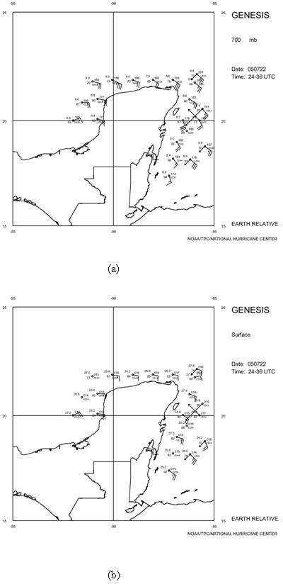 Based on the dropsonde data, the flight showed that the system was still an open
wave with an axis over the Yucatan (Fig. 23). Maximum winds at 700 mb were 35 kt in
the northeastern portion of the wave and at the surface they were 25 kt in the southeastern
portion of the wave. The sharper turning at 700 mb indicated that the wave showed up
more clearly at that altitude than at the surface. The strong winds accompanied by the
frequent episodes of convection also indicated that this was a rather vigorous wave.
Based on the dropsonde data, the flight showed that the system was still an open
wave with an axis over the Yucatan (Fig. 23). Maximum winds at 700 mb were 35 kt in
the northeastern portion of the wave and at the surface they were 25 kt in the southeastern
portion of the wave. The sharper turning at 700 mb indicated that the wave showed up
more clearly at that altitude than at the surface. The strong winds accompanied by the
frequent episodes of convection also indicated that this was a rather vigorous wave.
Rob Rogers
HRD Field Program director
Return to IFEX calendar page


![[OAR/DOC/NOAA Logos]](../../oar_noaa_doc_logos3.jpg)