[Atlantic Oceanographic and Meteorological Laboratory]


HRD Home
About AOML
About HRD
Programs
Data Sets
 yellow triangle bulletMission Catalog
 yellow triangle bulletSfc. Wind Anal.
 yellow triangle bulletSyn. Surveillance
 yellow triangle bulletRe-Anal. Proj.
 yellow triangle bulletBasin-Wide Data
 yellow triangle bulletData Formats
Weather Info
What's New
Links

OAR logo
OAR


NOAA 
Aircraft Operations Center Logo
NOAA Aircraft Operations Center

Site Map

Staff Data Center Contact  Information

Research Divisions


Hurricane Research 
Division

IFEX daily log

Friday, July 15, 2005

At the morning HRD conference call it was noticed that the area that had been the target of the previous daysŐ missions remained in an unfavorable environment, with 
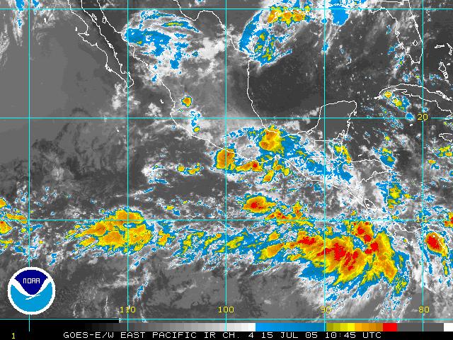
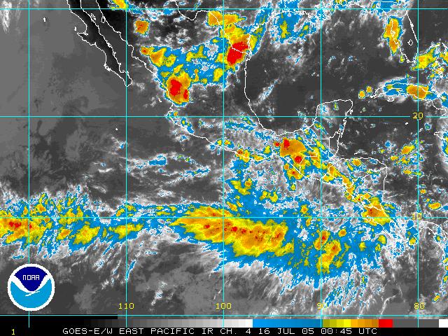
moderate to strong 20-kt vertical shear in the vicinity. To the southeast, infrared imagery (Fig. 5) showed a widespread area of deep convection just offshore Costa Rica. This general area had persisted since the previous day and was noticed in the discussions of the previous day. It had been discounted as being ITCZ-related convection, but severalfactors led to the conclusion that this may be the preferred location for genesis rather than the one being targeted the previous day. First, the convection was quite persistent. Second, the shear in this environment was more favorable for development than over the area targeted yesterday (Fig. 6). Shear in the zone that was targeted yesterday is still about 20 kts today, whereas the area with the persistent convection has a region of 5-10 kt shear on the northeast edge of the convection. Third, observations from the N43RF night flight indicated that there was fairly strong low-level northeasterlies off the west coast of Costa Rica and Nicaragua and southwesterly flow further out into the water, indicating a possible shear axis or convergence zone. Fourth, global model forecast ensembles (Fig. 7) have begun to predict genesis in the region just west of the deep convection in the next 1-3 days. For these reasons, we decided to shift our target to the area of deep convection between about 5 and 10 N and 84 and 90 W. The pattern planned for N42RF (Fig. 8) was a modified diamond pattern intended to cover the maximum amount of territory as possible. The axis of the diamond would be oriented along a WNW-ENE axis, roughly aligned parallel and just to the north of a convergence line suggested by QuikScat imagery confirmed by a subsequent overpass (Fig. 9). At flight level, there is a clear cyclonic shear axis or gyre centered roughly at7.5 N 85.5 W. There is some evidence of whitecaps at the surface south of this feature. It is possible that the feature was developed by the deep convection that had formed during the previous night, but that is impossible to say definitively since no aircraft was in this system the previous night, except for a passby with F/AST imagery by N43RF. There are large areas of anvil debris throughout much of the flight, and some areas of stratiform rain with convective elements embedded within them. There are several areas of near white-out conditions in terms of visibility due to the presence of stratiform cloud.

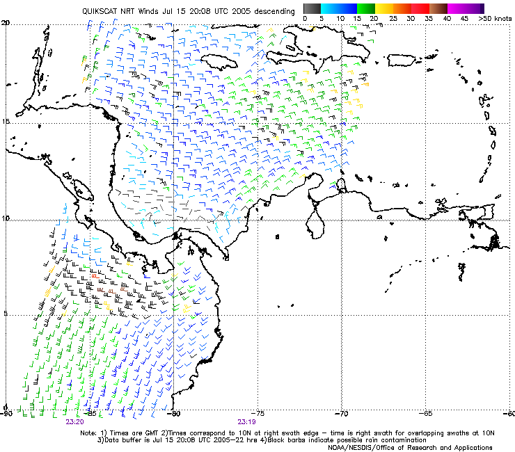
During the flight the pattern was modified slightly. The pattern was changed to cut off the northern tip of the top triangle, and to extend the southwest end of the pattern to the south and the east. The purpose of this change was to try to straddle the flight- level cyclonic wind shift (i.e., to provide more observations in the flight-level southwesterly flow.

Observations from the flight by N42RF during the day have helped to guide the pattern planning for N43RF. N43RF is planning to fly the square-spiral pattern, and have asked N42RF for a centroid for the pattern. Based on flight-level observations of the cyclonic wind shift/gyre, N42RF identified the center as being at 7.5 N 86 W. Assuming a movement of 6 degrees/day, that makes for a motion of 3 degrees over a 12-h period. This seems awfully fast, so an assumed motion of 1.5 degrees was made for the system. That puts the centroid at 7.5 N 87.5 W at the time N43RF will be in the pattern. The square-spiral pattern covers about 3 degrees of area, and takes about 3.5 to 4 h to execute. Since the ferry for this mission will be so short, the size of the pattern can be expanded if necessary. Upon further inspection of the flight-level winds, it appears that a fairly clearly-defined wave is evident, with an axis at about 87 or 88 W. That bodes well for possible future development, since there is a forcing mechanism (i.e., the wave) and the environment is favorable (i.e., relatively low shear and low-level convergence associated with strong southwesterly flow at the surface). It will be very interesting to see how the system evolves tonight and into tomorrow. Surface winds are strong southwesterlies throughout the region, with magnitudes as high as 25 kt.

By the end of the flight, infrared imagery (Fig. 10) showed widespread ITCZ convection at about 8 N 100 W and areas of convection in the target region around 8 N 88 W. The cloud patterns further west continue to show striations oriented NE-SW, suggesting a fair amount of northeasterly shear over that area, while the cloud patterns in the target area show much less evidence of experiencing shear, even though the amount of cold cloud tops is less than that further west. That may be normal, though, since the typical diurnal cycle is governed by little convection during the day and a blossoming of convection during the overnight hours. This is why it will be so important for N43RF to fly into the region tonight, and then for N42RF to fly into the same target the following day, to document the changes to the atmosphere that arose as a result of the convective heating.

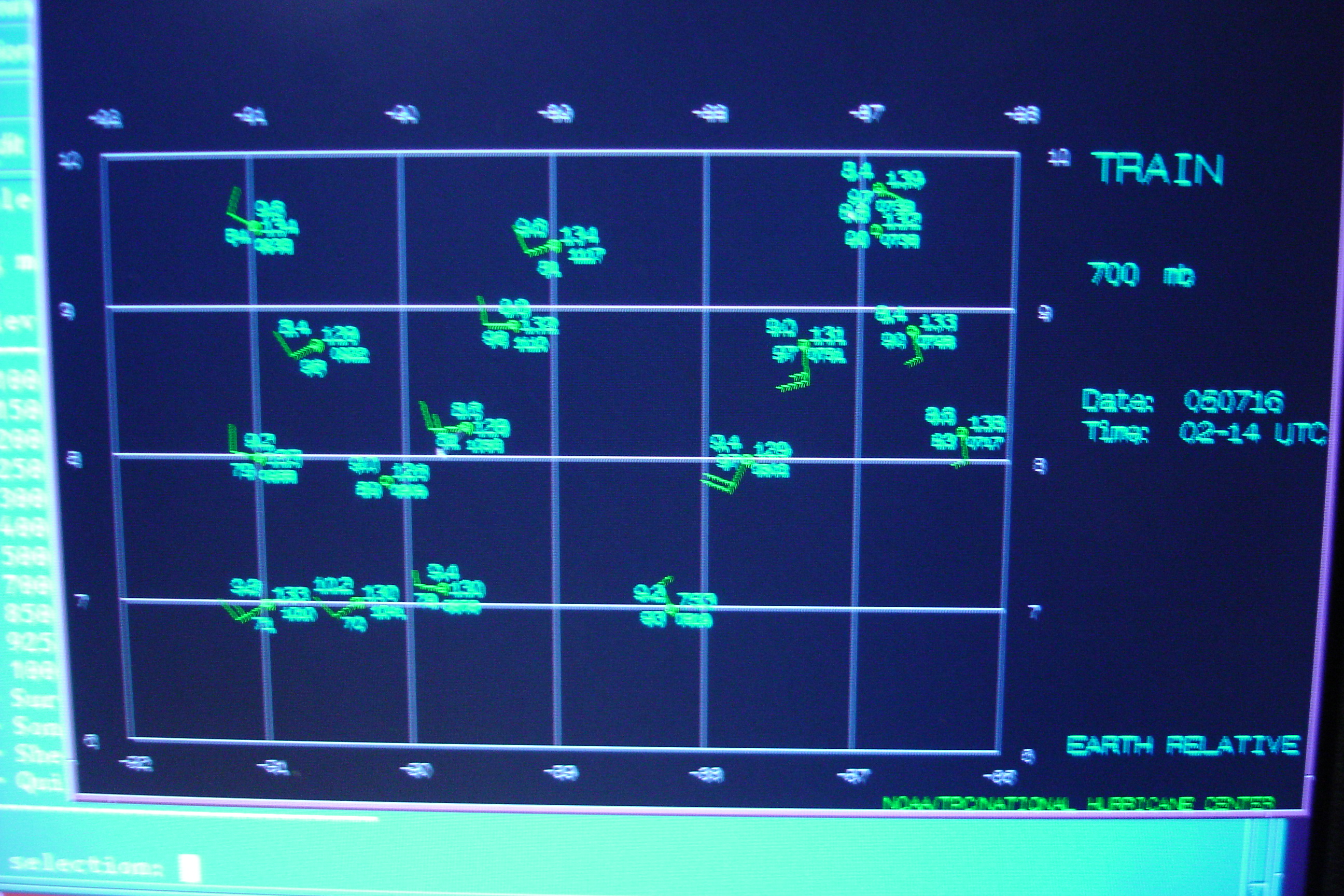
N43RF had a scheduled takeoff of 05 UTC. The flight plan called for a modified diamond pattern similar to that flown by N42RF during the day mission. This mission would be in conjunction with the NASA ER-2 (see 050716I mission summary for a more complete description of this flight). During the flight there was not as much widespread deep convection as had been expected, and N43RF had designed the pattern a bit too far to the south initially to see the possible circulation center at flight-level. However dropsonde measurements did show a possible shear axis or even a circulation center (Fig. 11) at about 10 N 88 W. The wind shift shows up well at 700 mb (Fig. 11a) and may be reflected at the surface by a cyclonic wind shift (Fig. 11b). The cyclonic shear zone thus seems to be coherent vertically.

Rob Rogers
HRD Field Program director


Return to IFEX calendar page

[Horizontal Rule]

[OAR/DOC/NOAA Logos] Atlantic Oceanographic and Meteorological Laboratory Logo [United States Department of Commerce] [Atlantic Oceanographic and Meteorological Laboratory] Atlantic Oceanographic and Meteorological Laboratory Logo [National Oceanic and Atmospheric Administration] [Office of Oceanic and Atmospheric Research] Department of Commerce Logo National Oceanic and Atmospheric Administration Logo Ocean and Atmospheric Research Logo

  Disclaimer | Privacy Policy
  DOC/NOAA/AOML/
HRD

aoml.hrdwebmaster@noaa.gov