[Atlantic Oceanographic and Meteorological Laboratory]


HRD Home
About AOML
About HRD
Programs
Data Sets
 yellow triangle bulletMission Catalog
 yellow triangle bulletSfc. Wind Anal.
 yellow triangle bulletSyn. Surveillance
 yellow triangle bulletRe-Anal. Proj.
 yellow triangle bulletBasin-Wide Data
 yellow triangle bulletData Formats
Weather Info
What's New
Links

OAR logo
NOAA Oceanic Atmospheric Research


NOAA Aircraft Operations Center Logo
NOAA Aircraft Operations Center

Site Map

Staff Data Center Contact  Information

Research Divisions


Hurricane Research Division

Summary of G-IV synoptic surveillance results
(1997 - 2003)

For assessments by year


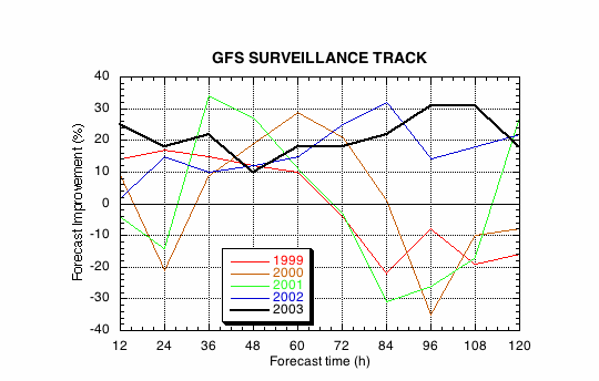
Figure 1. GFS track forecast improvements due to synoptic surveillance for all cases since 1999.


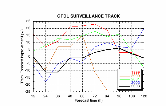
Figure 2. GFDL track forecast improvements due to synoptic surveillance for all cases since 1999.


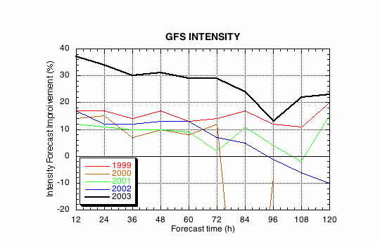
Figure 3. GFS intensity forecast improvements due to synoptic surveillance for all cases since 1999.


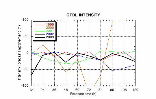
Figure 4. GFDL intensity forecast improvements due to synoptic surveillance for all cases since 1999.


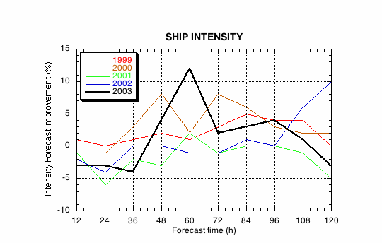
Figure 5. SHIP intensity forecast improvements due to synoptic surveillance for all cases since 1999.


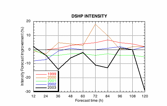
Figure 6. Landfall-SHIP intensity forecast improvements due to synoptic surveillance for all cases since 1999.

Return to assessments by year


[Horizontal Rule]

[OAR/DOC/NOAA Logos] Atlantic Oceanographic and Meteorological Laboratory Logo [United States Department of Commerce] [Atlantic Oceanographic and Meteorological Laboratory] Atlantic Oceanographic and Meteorological Laboratory Logo [National Oceanic and Atmospheric Administration] [Office of Oceanic and Atmospheric Research] Department of Commerce Logo National Oceanic and Atmospheric Administration Logo Ocean and Atmospheric Research Logo

  Disclaimer | Privacy Policy
  DOC/NOAA/AOML/
HRD

aoml.hrdwebmaster@noaa.gov