 NOAA Miami Regional Library
National Hurricane Center Branch
| NOAA Miami Regional Library National Hurricane Center Branch |
| Home
Page
Library
Info -
Links
|
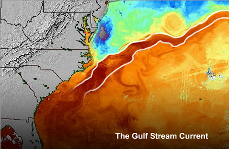
This data was generated by Dr. Stephen Baig, National Hurricane
Center, Storm Surge Unit, Team Learder (retired).
The data consists
of charts of the Gulf Stream system,
from the Yucatan Channel to the offing of
When printed the charts are often intended to
be pieced together to show a larger area of the current.
This
product was used by parties involved in marine
related activity from recreational boaters, professional fisherman,
cruise ships, the Coast Guard, academia and others.
Selected portions of the sea
surface thermal anaylsis were made available on
NOAA radio.
In general, increased access to
data sets has been
an advancing trend in research for several years. In addition, new technologies have enabled comparison and combinations between various data groups expanding use of the research. Systems such as Geographic Information Systems (GIS) have become a common tool allowing the user to tie various data to locations and display results in graphic form via interactive queries.
The data are posted here for the general
public and for the purpose of extending ongoing research in
this region which may include, but is not limited to, XBT
temperature signals, investigation into the expansion
and contraction of the
Acknowledgement
The
NHC Library would like to
acknowledge and thank Dr. Hugh
Willoughby, Florida InternationalUniversity (FIU), Earth and Environment professor and
Giselle Castano, FIU senior for their collaborative efforts in this digitization project. (August, 2015)
|
| Catalog | E-Resources | E-Journal |
| National
Hurricane Center Library 11691 S.W. 17th St. Miami, Florida 33165 Nhclibrary@noaa.gov 305-229-4406 |
NOAA
is a division of the Department of Commerce |
Privacy
| Disclaimer
This
web site is hosted by AOML |