

Since its implementation in 2007, NOAA’s Hurricane Weather Research and Forecasting (HWRF) model has paved the way for major improvements in tropical cyclone prediction. These developments in hurricane modeling give forecasters a clearer picture of a storm’s behavior, allowing them to warn at-risk communities further in advance. The HWRF model was able to assimilate a wide range of data inputs to produce realistic hurricanes, which increased forecasters confidence in its predictions. Throughout the sixteen-year study period, there were several key developments in the model that contributed to its success and increased reliability in hurricane forecasting.
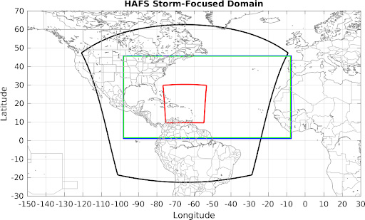
The most significant accuracy improvement is attributed to increased resolution. By shrinking the distance between forecast points from 9 km in 2007 to 2 km in 2018, scientists created a moving nest, which follows a storm throughout the forecast period; smaller distances between forecast points allow the model to track movement of a storm with greater precision. Higher resolution can be computationally expensive, but the moving nests mitigate that cost by limiting high resolution to the storm. These nests improve the prediction of the near-storm environment and conditions in the inner core, which are critical in predicting a storm’s intensity. Further model development later allowed for the creation of an even smaller nest with a spacing of 1.5 km; this high resolution inner moving nest allowed for improvement of physics, data assimilation, and ocean coupling in hurricane forecasting.
However, scientists needed to include in-situ information about a storm’s behavior to improve their forecasts. Improvements in data assimilation allow HWRF to incorporate information from satellites and Hurricane Hunter flights that provide real-time information about the conditions inside a storm. This allowed the model to create more accurate intensity forecasts for the Continental U.S. through the improved use of hurricane reconnaissance data.
There are many environmental conditions that affect the development of a tropical storm and are used in hurricane modeling. Frequent use of physical parameterization schemes incorporates information about the surface winds, clouds, and available energy in the atmosphere to analyze how they affect a storm’s behavior. In addition to atmospheric information, HWRF uses improved ocean coupling to capture movement and mixing beneath the storm. Tropical storms rely on heat from the water to provide energy for development and intensification; understanding the behavior of the ocean below a hurricane gives scientists a clearer picture of the amount of energy available for a storm to intensify.
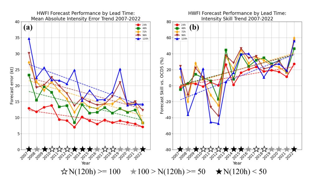
The HWRF model underwent extensive developments in the sixteen-year research period with the goal of creating a more accurate intensity prediction model. Improvements in resolution, data assimilation, ocean coupling and physical parameterization schemes enabled HWRF to cut forecast intensity errors in half, and improve rapid intensification forecasts by 50%. These successes paved the way for NOAA’s next-generation hurricane model, the Hurricane Analysis and Forecast System (HAFS).
HAFS has emerged as the newest forecasting model at NOAA to build upon HWRF’s success. HAFS was formally adopted in 2023 as NOAA’s new flagship hurricane model, with support from many of the same developers that worked on HWRF. The HWRF model is considered one of the most important and successful ocean-coupled, regional numerical weather prediction models. HWRF’s impressive performance during this time left a lasting legacy to hurricane forecasting that will continue propelling HAFS and future models to new heights.