Real
Time Current Measurement System:
As
a result of increasing export/import shipping and cruise line
activities, thePort of Miami (POM) is currently conducting a
major expansion of the turning basin at the south side of the
Dodge Island port facility. This project will resultin the need
to relocate up to 20,000 cubic yards of dredge material,from
the port, daily for several years. The approved site for placement
of the dredge material is known as the Offshore Dredge Material
Disposal Site (ODMDS). The ODMDS constitutes a 1 nautical mile
(NM) square oriented along lines of latitude and longitude.
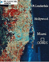
About
one mile west of the western boundary of the site is an extensive
area of environmentally and commercially valuable coral reefs.
This sensitive area is under both State and Federal jurisdiction.
RSD,
in cooperation with the Rosenstiel School of Marine and Atmospheric
Science of the University of Miami, was called upon to design
a discharge procedure which would allow port dredging to occur
while protecting the aforementioned coral reefs. As a result,
a novel discharge and permitting approach was developed. Discharge
is not to occur at the site if the westerly component of the
ambient current exceeds 12 cm/sec.
For
the first time, near real time measurements of oceanic current
speed and direction at the disposal site are being used to regulate
the disposal of dredge material. This requirement has led to
the need to place a Real Time Current Measurement System (RTCMS)
on the ocean bottom near the disposal site. Discharge is not
permitted to occur unless ambient currents do not transport
material toward the coral reefs. A complex but highly successful
linkage of scientific data and management decision has been
achieved. The system utilizes a 150 kHz upward looking Acoustic
Doppler Current Profiler (ADCP) to obtain water column current
profiles every twenty minutes. A running one hour temporal average
of the currents, averaged vertically over the top fifty meters
of the water column is provided every twenty minutes. If the
westerly component of the vertically and temporally averaged
current exceeds 12 cm/sec an
advice of no-discharge is rendered to the dredging company.
This project may serve as a prototype for port dredging projects
nationally in the future.
The
RTCMS consists of six distinct subsystems

- A
Tethered ADCP
- 2
suspended eloctromechanical cables (1,250') moored at 2 points
- A
deep water (60'-500') electromechanical bottom cable. (12,000')
- A
shallow water (20'-60') electromechanical bottom cable. (6,000').
- A
microprocessor controlled radio modem.
- A
data recording and processing computer.
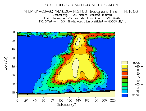
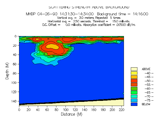
Shown below are four sequential acoustic visualizations
of a plume of coastal ocean discharged dredge material from
the Port of Miami. These images show the distribution of
plume material as a function of depth, distance, and time.
The first image (a) was gathered by a ship towing an acoustical
device over the discharge site about one minute
after completion of discharge. Note that the plume has impacted
the bottom (120 meters depth) and generated a bottom surge.
Images (b), (c), and (d) were made at increasing times after
discharge. The plume material remaining within the water
column (called the "residual" plume) moves with
ambient currents. The ambient currents are monitored, in
real time, using the RTCMS system described above. This
is an example of OAA/RSD efforts to move from a reactive
to a preventive mode in support of environmentally sustainable
economic development.
Acoustic iso-concentration contours of four transects. The
gap in concentration indicated in (a) at horizontal distance
coordinate of 90 to 100 m is attributed to acoustic absorption
at the frequency of 20 kHz by a cloud of bubbles in the
water near the surface. Horizontal distances in (a) and
(b) are greater than those of (c) and (d) in
order to present the whole feature of the surge plume.
City
Of Miami
Phod ADCP
Data