Tropical Cylone Dynamic Temperature
PI: Gregory Foltz
Collaborator: Karthik Balaguru
A tropical cyclone (TC) draws energy from the underlying ocean, converting the ocean's heat into the mechanical energy of its circulation. TCs also induce vigorous mixing of the upper ocean that reduces sea surface temperature (SST) as the storm passes. This storm-induced cooling is referred to as the cold wake. Ideally, the SST directly under a storm would be used to assess and predict changes in TC intensity. However, in practice this is very difficult to measure and challenging to predict in models because of the variety of factors that affect a storm's cold wake, including storm translation speed, strength, and size, and upper-ocean temperature structure, to name a few.
One of the earliest methods to estimate the subsurface ocean's influence on TC intensification is Tropical Cyclone Heat Potential (TCHP; Shay et al. 2000, Mainelli et al. 2008), a measure of the ocean's heat content above the 26 degree isotherm. A simple vertical average of temperature between the surface and a depth of 100 m (T100) has also been used (Price 2009, Lin et al. 2013). The reasoning behind these metrics is that a warmer, deeper layer of water in the upper ocean will act to decrease the magnitude of a TC's cold wake, thus favoring intensification. However, neither TCHP nor T100 accounts for variations in the vertical extent of mixing in the ocean, which depends on various storm and ocean parameters. Another weakness of previous methods is that they do not account for the vertical distribution of temperature stratification. For example, uniform temperature of 28C in the upper 100 m will give the same TCHP and T100 as temperature of 30C between the surface and 50 m and 26C from 50 m to 100 m. In reality, the first case will result in a very small cold wake, favoring intensifcation, while the second case will generate a larger cold wake, possibly resulting in an SST felt by the storm that is lower compared to the first case, and hence weaker TC intensification.
An improved method to estimate the ocean's impact on TC intensifcation was recently developed ( Balaguru et al. 2015). It estimates a variable mixing length (i.e., depth of penetration of TC-induced mixing) based on upper-ocean stratification and storm translation speed and intensity, then averages temperature vertically from the surface to the mixing length. The resulting Dynamic Temperature (Tdy) improves upon previous methods ( Balaguru et al. 2015), is useful for diagnosing the causes of TCs' intensity changes ( Balaguru et al. 2016, Foltz and Balaguru 2016), and improves statistical hurricane intensity forecasts in the Atlantic (Balaguru et al. 2017, submitted to Wea. Forecasting). Monthly gridded maps of Tdy are available starting in 1993, and work is underway on a near-real-time weekly product.
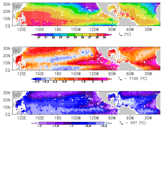
Caption June-November means of (a) Tdy, (b) Tdy-T100, and (c) Tdy-SST, using a TC wind speed of 50 m/s and translation speed of 5 m/s in the calculation of Tdy.