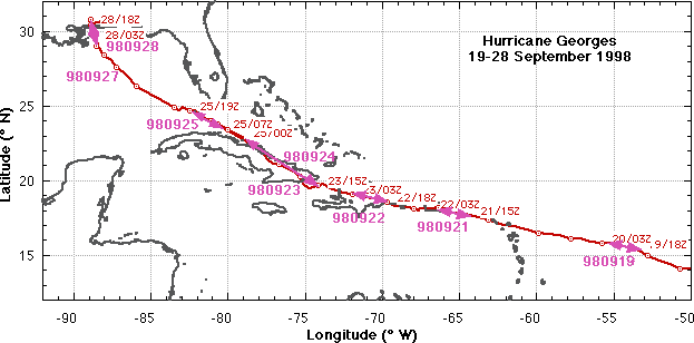
Georges: (19-28 September 1998)
 Georges
moved off the African coast on 13 September, rapidly going from depression
to tropical storm to hurricane in <4 days. By 17 September Georges was
an intensifying hurricane within 3-4 days of striking the US Virgin Islands
and Puerto Rico. NHC tasked the NOAA G-IV for a surveillance
mission around Georges on 18 September. HRD and AOC planned a 3-aircraft
(WP-3Ds and the G-IV) synoptic surveillance mission as Georges approached
the Windward Islands.
Georges
moved off the African coast on 13 September, rapidly going from depression
to tropical storm to hurricane in <4 days. By 17 September Georges was
an intensifying hurricane within 3-4 days of striking the US Virgin Islands
and Puerto Rico. NHC tasked the NOAA G-IV for a surveillance
mission around Georges on 18 September. HRD and AOC planned a 3-aircraft
(WP-3Ds and the G-IV) synoptic surveillance mission as Georges approached
the Windward Islands.
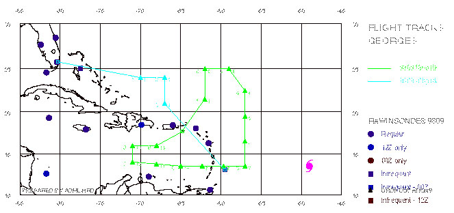
On 18 September the G-IV flew a single-aircraft synoptic
surveillance mission as part of the ferry flight, landing in St Croix, and
the WP-3Ds ferried to Barbados dropping some sondes in support of the G-IV
mission. On 19 September the three airplanes flew a combined synoptic surveillance
mission successfully. Both WP-3D aircraft made three penetrations with 50
nm radius legs of the intense
core (category 4, 936 mb central pressure, >130 kt winds), one early
in the pattern and the second late. Both aircraft dropped multiple GPS sondes
in the core rainbands and eyewall. The G-IV landed in Bermuda, away from
the projected path of the storm, and the WP-3Ds back in Barbados. The aircraft
did not fly on Sunday 20 September as the storm entered the lesser Antilles.
GPS dropsonde (HSA) data format
 Back to summary page
On 21 September, all three aircraft again flew a 3-plane
synoptic surveillance mission, with one WP-3D flying
a pattern focused on the core of Georges' vortex as it crossed St. Croix
and approached the eastern end of Puerto Rico, and the other WP-3D and the
G-IV flying synoptic surveillance. All three airplanes landed at Opalocka.
The WP-3D flying the core made three penetrations of the eye with 60 nm
radius legs, finding that the storm had weakened considerable due to increased
upper level wind shear affecting the inner core. They found a very asymmetric
reflectivity and wind field at all levels. The NASA
DC-8 and ER-2, with only a two days left to fly, joined in the surveillance
mission on the 21st focusing on the core, joint with the WP-3D mission.
| Storm/ Date |
Aircraft (Duration) |
Altitude |
Experiment |
Comments (expendables) |
| Georges |
|
|
|
|
| 21 September |
G-IV (9 h)
GPS dropsondes
N42RF (9.5 h) mission summary (460
Kb) (460
Kb)
1 minute listing
GPS dropsondes
N43RF (9 h) mission summary(312
Kb)
1 minute listing
GPS dropsondes
WC-130
DC-8 (8 h) mission summary
ER-2 (7 h) |
41 kft
16-23 kft
18-23 kft
5000 ft
37 kft
65 kft |
3-plane Synoptic Surveillance with coordinated XCDX inner
core pattern.
N42RF (early) three 60 nm radius legs in core and N43RF (late) .
AFRES recon.
DC-8 and ER-2 inner core pattern over storm |
- Georges crossing St. Croix and approaching E end of Puerto Rico. N42RF
found Georges had weakened due to increased upper level wind shear. Asymmetric
reflectivity and wind field at all levels, radius 20 nm.
- DC-8
and ER-2 coordinate core pattern with N42RF at extreme range
- N42RF made numerous eyewall drops with AXBTs
- G-IV dropped 30 dropsondes N of the storm
(2 WP-3D: 35 GPS sondes, ~12 AXBTs) |
Back to summary page
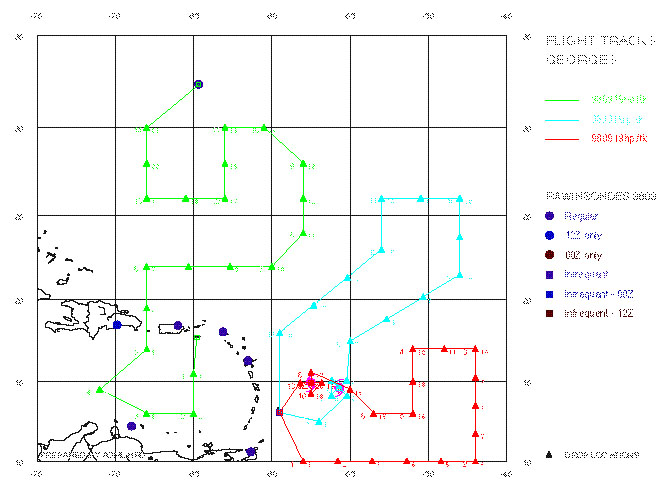
On 22 September, one WP-3D and the G-IV flew a 4th
synoptic surveillance mission around Georges as it crossed Hispaniola, in
conjunction with the NASA DC-8 and ER-2. The second WP-3D was held in reserve
so that it would be available to fly operational reconnaissance as the storm
was forecast to enter Cuban water the next day. The DC-8
and ER-2 penetrated the storm over Hispaniola, with the DC-8 moving
to the S of Hispaniola to do an inflow pattern, while the DC-8 stayed over
Hispaniola monitoring the storm as it interacted with the 9-10,000 ft mountains
in Haiti. The ER-2 pilot reported a spectacular lightning show as the eye
gradually filled in and the convection got very vigorous.
| Storm/ Date |
Aircraft (Duration) |
Altitude |
Experiment |
Comments (expendables) |
| Georges |
|
|
|
|
| 22 September |
G-IV (9 h)
GPS dropsondes
N43RF (9.5 h) mission summary(8
Kb)
1 minute listing
GPS dropsondes
WC-130
DC-8 (8 h) mission summary
ER-2 (7 h) |
41 kft
18-23 kft
5000 ft
37 kft
65 kft |
2-plane Synoptic Surveillance N43RF S of Hispaniola while eye
over land .
AFRES recon.
DC-8 LASE WV profiles in inflow S of Hispaniola
ER-2 core pattern in storm over Hispaniola |
- G-IV dropped 28 dropsondes N of storm while N43RF dropped 19 sondes
S of Cuba and Haiti as Georges crossed Hispaniola.
- DC-8
and ER-2 penetrated the storm over Hispaniola, with DC-8 moving to
the S of Hispaniola to do inflow pattern, while the ER-2 stayed over Hispaniola
monitoring the storm as it interacted with 10,000 ft mountains. ER-2 pilot
reported spectacular lightning vigorous convection even as eye filled.
|
Back to summary page
On 23 September the G-IV flew a fifth synoptic surveillance
mission while the WP-3D aircraft began a series of 5 straight reconnaissance
missions while Georges crossed the Windward Passage into Cuban waters.
| Storm/ Date |
Aircraft (Duration) |
Altitude |
Experiment |
Comments (expendables) |
| Georges |
|
|
|
|
| 23 September |
G-IV (9 h)
GPS dropsondes
N42RF (9.5 h) mission summary(8
Kb)
GPS dropsondes
N43RF (9.5 h) |
41 kft
5000 ft
5000 ft |
Synoptic Surveillance
N42RF Recon. early W of Hispaniola .
N43RF Recon. late E around eastern Cuba |
- G-IV dropped 30 dropsondes
Storm center over Mona Passage between Haiti and Cuba. No eyewall, peak
winds around 80 kts.
- N42RF flew abbreviated Fig. 4 to define radius of 35 kt winds
Storm center moves over SE Cuba. Dropped 10 GPS sondes for surface winds.
- N43RF flew abbreviated Fig. 4 legs to define radius of 35 kt winds.
No GPS sondes dropped.
|
Back to summary page
The reconn flights, needed to fill in for Air Force
Reserve WC-130s which cannot enter Cuban airspace. The first WP-3D flew
reconnaissance in and out of Opalocka on the evening of 23 September in
the Windward passage; the second and third WP-3D flew a beach patrol on
24 September while the center was over land in SE Cuba; the fourth reconn
flight was in the FL straights on
25 September as the storm started to approach
Key West, FL. The fifth reconn mission also on the 25th ended up being a
landfall mission over the lower Keys. We were able to get true dual Doppler
winds by coordinating the aircraft radials with the Key West WSR-88D. We
also dropped GPS sondes to get reliable low-level winds. The NASA
ER-2 joined this mission over the FL Keys. All of the reconn missions
were carried out despite having only two crews and aircraft, having to move
crews from Miami to Tampa and then to Savannah, GA as Georges first threatened
S FL, and then Tampa (forcing the closing of MacDill AFB. At the same time
the ER-2 had to relocate to Warner Robbins AFB in Macon, GA. The G-IV continued
doing surveillance mission around the storm on the 23rd, 25th, and 26th
hopscotching from Miami to MacDill, to Savannah, to Corpus Christi, TX.
| Storm/ Date |
Aircraft (Duration) |
Altitude |
Experiment |
Comments (expendables) |
| Georges |
|
|
|
|
| 24 September |
N42RF (9.5 h) |
5000 ft |
N42RF Recon. around eastern Cuba
GPS dropsondes |
- Storm over SE Cuba. N42RF legs to define radius of 35 kt winds. Dropped
5 GPS sondes for surface winds.
|
| 25 September |
G-IV (9 h)
GPS dropsondes
N43RF (9.5 h) mission summary(84 Kb)
1 minute listing
GPS dropsondes
N42RF (9.5 h) mission summary(140 Kb)
1 minute listing
GPS dropsondes
ER-2 (7h) mission summary |
41 kft
5000 ft
5000 ft
65 kft |
Synoptic Surveillance
N43RF Recon. as storm moved off Cuba.
N42RF Recon. over FL Keys
ER-2 inner core pattern over storm with N42RF |
- N43RF early - Georges over water in FL straits. Eyewall asymmetric,
with 85 kt winds. Dropped 2 GPS sondes for surface winds.
SRA mapped 2-D wave spectra.
- N42RF late - landfall mission over lower FL Keys. Coordinated aircraft
legs with Key West WSR-88D. Dropped 8 GPS sondes for surface winds.
- ER-2
joined N42RF mission over Keys. ER-2 noted eye appeared and disappeared
between passes. Turbulence at 63 kft, smooth at 65 kft. Clouds around eye
a "bubbling caldron."
- G-IV dropped 26 sondes E and W of storm
|
Back to summary page
The G-IV did one final surveillance mission over the Gulf of Mexico on
26 September. CAMEX-3
had one final ER-2 flight during the day 27 September to fly a TRMM
overpass over the storm and do radial legs from the WSR-88Ds at Slidell
and Mobile.
| Storm/ Date |
Aircraft (Duration) |
Altitude |
Experiment |
Comments (expendables) |
| Georges |
|
|
|
|
| 26 September |
G-IV (9 h)
GPS dropsondes
WC-130 |
41 kft
5000 ft |
Synoptic Surveillance
AFRES recon. |
- G-IV dropped 20 dropsondes over W Gulf.
|
| 27 September |
WC-130
ER-2 (7 h) mission summary |
5000 ft
65 kft |
AFRES recon.
ER-2 TRMM patterns working with KEVX and KLIX |
- ER-2 flew triangular pattern from Fort Walton Beach, FL W to Slidell,
LA, to 28°N, 88°W S of the forecast position of the eye. The triangular
pattern was flown twice before underflight of TRMM satellite. Then repeat
triangular pattern.
- Solid cirrus shield during triangular pattern. No cloud feature resembling
an eye until the TRMM subtrack when feature S of track had bubbling cloud
formations.
|
Back to summary page
HRD and AOC flew two WP-3D sorties straddling
the expected landfall time of 1200 Z 28 September (it sat on the coast between
11-1400 Z). The first mission from 0300-1200 Z dropped GPS sondes over C-MAN
sights and worked dual Doppler legs with the 2 OU DOWS and the WSR-88Ds,
and the second mission from 0900-1800Z focussed on mapping
the storm surge with the SRA along the coast from Mobile Bay to Slidell
and dual-Doppler with the WSR-88Ds and DOWs. The two University of Oklahoma/NCAR
(OU) DOWs were stationed in
Mississippi, one in Biloxi and the other in Gulfport. The University
of Alabama/Huntsville (UAH) portable profiler was in Lyman, MS 6 nm
N of Gulfport, and the Texas
Tech (TTU) portable instrumented tower was in Biloxi. As the storm circulation
made landfall N43RF did Fig-4s over land and the nearby water with N-S legs
bisecting the DOW baseline and E-W legs along the beach mapping
the storm surge with the SRA. Two other portable instrumented towers
from Clemson University and OU were located 60 nm to the W at Slidell, LA
(location of the WSR-88D), while about 50 nm to the E two
OU portable mesonets were moving up and down I-10 between Pascagoula,
MS and Mobile, AL (location of the second WSR-88D). With this array of instrumentation,
Georges became the best sampled landfalling hurricane ever.
| Storm/ Date |
Aircraft (Duration) |
Altitude |
Experiment |
Comments (expendables) |
| Georges |
|
|
|
|
| 28 September |
N42RF (9.5 h) mission summary(96 Kb)
1 minute listing
GPS dropsondes
N43RF (9.5 h) mission summary(328 Kb)
1 minute listing
GPS dropsondes
WC-130 |
14 kft
7000 ft
10 kft |
Hurricanes at Landfall
N42RF early: Fig 4, zig-zag in major rainband with legs toward KMOB, KEVX
and KLIX
N43RF late: legs toward KMOB, KEVX and KLIX, plus SRA runs along Gulf
coast from Pensacola to Lake Ponchartrain for storm surge
AFRES recon. |
- Georges landfall in MS.
15 nm radius eyewall just off the coast early, and partially over land
late.
- Numerous eyewall drops with AXBTs from N42RF and over C-MAN sites by
both WP-3D.
- SRA imaged storm surge
from Mobile Bay to Lake Ponchartrain
- 2 OU DOW (Gulfport and
Biloxi, MS), UAH profiler (Lymon, MS),
OU portable mesonet
(I-10 between Pascagoula, MS and Mobile, AL), and TTU,
Clemson and OU instrumented towers along Gulf coast from Slidell to Mobile.
(2 WP-3D: 69 GPS sondes, 15 AXBT) |
©1998 NOAA/AOML Hurricane Research Division
Back to summary page
For information about NOAA Hurricane Field Program
marks@aoml.noaa.gov
Updated Tuesday, 27 October 1998