

(PIs: Kevin Knupp and Bill McCaul (USRA))
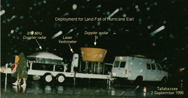 |
Two Deployments:Earl (1-2 September 1998) - Tallahassee, FLGeorges (27-29 September 1989) - Lymon, MS |
![]()
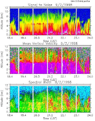
The UAH MIPS was set up at KTLH (Tallahassee Airport) by 2300 UTC. The 915 MHz radar system performed good, and the data set is good). Three beams were used, vertical beam data every 40 s and an independent wind vector is retrieved every 80 s. At least one very strong vertical motion couplet was observed in the boundary layer, estimated max/min is 17 m/s up followed by 10 m/s down, each peaking near 800 m AGL, and seemingly confined to the lowest 1.5 km AGL. It is not clear what this was, and there may have been more (boundary layer rolls perhaps?). Very interesting structures in W throughout the depth of the system; large shear associated with primary rainband that passed over.
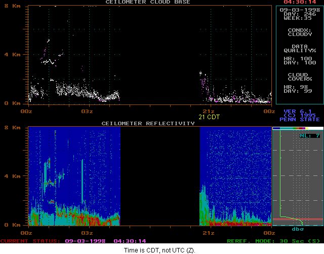
Peak horizontal winds near 800 m AGL (nice low-level jet (LLJ) structure) in the neighborhood of 30-35 m/s, peak winds dropped after the passage of the primary rainband (after ~0300 UTC). The Sodar system performed well, but the data set in only fair to good because of rain noise, but most often the system sampled the first 2-3 gates. This is important wind information since it fills in the gap between 5 m wind and the first profiler gate (130 m AGL). These data show large shear. The RASS system performed fair to good, and the data set is fair. They could have done better here, since they did not have parameters optimized, but preliminary indications show a stable ABL structure (difference in Tv between 100 m and 500 m on the order to 1-2 K., RASS coverage was up to 400-600 m AGL, and could have been pushed up to 700 m AGL with better parameter settings. The ceilometer system performed good, and the data set is good. Recording started later with this due to computer problems, but the data look interesting. It performed MUCH better than he had anticipated. It penetrated the rain very well and showed a highly fluctuating cloud base. Cloud base varied between ~200 m at times and 2.5 km. This is interesting in view of the nearly saturated air near the surface (it was quite cool, near 22-23 C most of the time).
MIPS Instruments:
Location: vacant parking lot of the old terminal building at the Tallahassee airport, 1.5 km N of the WS-88D
Data collection: 2300 UTC 9/2 to 1200 UTC 9/3, (gap between 0700 UTC and 1200 UTC due to a ciruit breaker tripping)
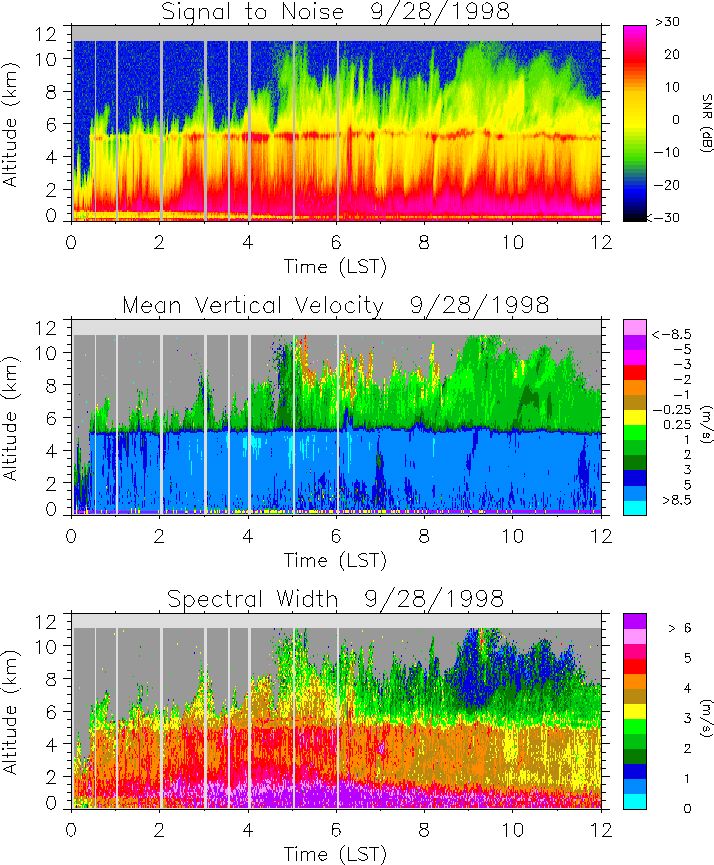
The UAH team (Knupp, McCaul, Walters, Cook and Paech) departed HSV at 1300 CDT on 9/26 for the Georges landfall hurricane experiment. The team spent the night in Mobile, AL, while making final plans for deployment the next morning. Initially, we considered deploying at a rest stop along I-10 just west of the AL-MS border, about 15 km SW of the Mobile WSR-88D. By the following morning, we decided to move operations further west, near Gulfport, MS, to coordinate with the OU Doppler on Wheels (DOW) radars. At that time, the eye of Georges was expected to make landfall near New Orleans, LA. We arrived at a site near Lyman, MS, 8 km north of Gulfport, and about 16 km north of the shoreline, near 1000 CDT Sunday morning. All MIPS components were up and operational by 1100 CDT (1600 UTC). Shortly after this, the initial rainbands moved over the MIPS site. Data were recorded at this site for the next 40 hours.
The western eyewall of Georges affected the MIPS site for more than eight hours on the morning of 9/28, as the hurricane center drifted slowly north, passing just several km east of Lyman. A peak wind gust of 37 m/s was observed at 1323 UTC on 9/28, with gusts exceeding 30 m/s occurring between 0900 and 1500 UTC. (Note: the MIPS site was protected by trees and an ~8 m tall, warehouse building located some 100 m to the north.) The minimum station pressure was about 969 mb, suggesting the close proximity of the profiler to the storm center. From inspection of time vs. height sections of vertical beam measurements of mean velocity and Doppler spectrum variance, it appears that the boundary layer depth was ~2 km through the period of high winds. RASS data obtained before the arrival of the eyewall onslaught suggest that the lower levels were statically stable. The data also show distinctly stratiform conditions for most of the period. Within the eyewall, only very weak convective scale updrafts were observed near echo top (8-11 km AGL).
Highlights:
Problems:
Some noteworthy logistical considerations:
Need a good plan for deployment strategy. Metallic-clad buildings produce very strong ground clutter interference, even in moderate to heavy rain conditions. The parking lot environment (with many light poles) in TLH was not as bad, but still less than
MIPS Instruments:
Location: near Lyman, MS, 3.6 mi N of I-10 (16 km north of the shoreline), lat/lon = 30° 29.425' N, 89° 06.105' W
Time period of measurements: 16 Z 27 Sept. to 08-12 Z 29 Sept.