 Earl: (1-2 September
1998)Earl: (1-2 September
1998)
Earl: (1-2 September
1998)Earl: (1-2 September
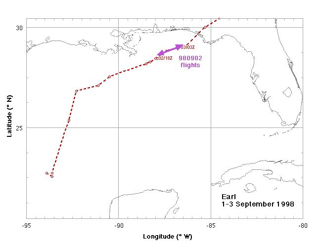
1998)The tropical wave between those that formed Bonnie and Danielle slipped into the Gulf of Mexico and triggered a lot of deep convection. On 1 September it was upgraded to tropical storm Earl, bypassing the depression phase, and the forecasters and AFRES aircraft had a hard time finding the disturbance center, repositioning a number of times in the initial twelve hours. A NOAA G-IVSP surveillance mission was conducted on 1 September indicating a short wave trough was sweeping in over TX and should overtake TS Earl in the next 24 h.
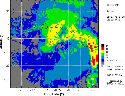
During the morning of 2 September Earl became a hurricane as it raced ENE toward the FL panhandle with landfall near Panama City. The Texas Tech Univertity (TTU) tower was in Panama City and the University of Alabama/Huntsville (UAH) profiler was in Tallahassee, FL. WP-3D (N43RF) took off at 1900 UTC for a landfall and storm surge mapping mission at 15,000 and 8,000 ft, while the DC-8 and ER-2 took off at 1930 UTC for a TRMM/Landfall mission at 35,000 and 65,000, respectively. AFRES WC-130 did reconnaissance and the University of North Dakota (UND) Citation participated in the TRMM mission.
GPS dropsonde (HSA) data format| Storm/Date | Aircraft (Duration) | Altitude | Experiment | Comments (expendables) |
| Earl | ||||
| 1 September | G-IV (9 h) GPS dropsondes |
41 kft | Synoptic Surveillance | 31 GPS sondes |
| 2 September | N43RF (8.5 h) mission
summary WC-130 DC-8 (9 h) mission summary ER-2 (7 h) Citation (5 h) mission summary |
|
Hurricanes at Landfall Fig 4, zig-zag in major rainband with legs toward KEVX and KTLH, SRA
runs along Appalachie Bay for storm surge AFRES recon. DC-8, ER-2 and UND Citation TRMM patterns working with KEVX and KTLH |
|
Updated Tuesday, 15 September 1998![]()