Tropical Cyclone Winds at Landfall Experimental Options
This document is divided into FIVE sections:
Real-time Module
The real-time module combines passes over marine
surface platforms with one or more figure four patterns in the core of the
hurricane. The aircraft flies at or below 5,000 ft (1.5 km) (ideally at
2,500 ft [750 m]), so that flight level winds can be adjusted to 30 ft (10
m) to combine with measurements from marine surface platforms. Flight-level
data and GPS-sondes dropped near the platforms will be used to validate the
adjustment method. Doppler data collected in the figure four will be
analyzed with EVTD in real-time on the HRD workstation. The lowest level of
the EVTD analysis may be sent to TPC/NHC where the Doppler winds can also
be adjusted to the surface and made available to HRD's real-time surface
wind analysis system. Note that if the storm is outside of WSR-88D Doppler
range then the figure four pattern could be repeated before returning home.
For example, if a hurricane moves within range of Melbourne,
Florida, then the flight pattern should take advantage of buoys 41009 and
41010. The aircraft descends at the initial point and begins a low-level
figure-4 pattern, modifying the legs to fly over the buoys (Fig. 20).

Whenever the drift angle permits the radar will be in F/AST mode, except in
the eye penetrations. If time permits the aircraft would make one more pass
through the eye and then fly the dual-Doppler module. In this example the
pattern would be completed in about 2.5 h. GPS-sondes would be dropped near
the buoys.
[Return to table of contents above]
Dual-Doppler Option 1
If the TC moves within Doppler range of a
coastal WSR-88D 125 nmi (230 km), then we will fly a second module, to
collect a time-series of dual-Doppler data from the storm's inner core.
Note that the optimal volume scans for this pattern will be obtained when
the storm is 32-80 nmi (60-150 km) from the radar, because beyond 80 nmi
(150 km) the lowest WSR-88D scan will be above 5,000 ft (1.5 km) which is
too high to resolve the low-level wind field. Within 32 nmi (60 km) the
volume scan will be incomplete, because the WSR-88D does not scan above
19.5?.
The pattern will depend on the location of the storm relative to
the coastal radar. Depending on safety and operational considerations, the
aircraft could fly this portion of the experiment at a higher altitude,
although 5,000 ft (1.5 km) would still be preferred. Continuing our example
for the Melbourne WSR-88D, after completing the real-time module the
aircraft flies to an initial point on the track intersecting the storm
center and the coastal radar (Fig. 20). The aircraft then makes several
passes through the eyewall (A-B in Fig. 20), with the tail radar scanning
perpendicularly to the track. Depending on the size of the eyewall each
pass should last 10-20 min. It is essential that these passes be flown as
straight as possible, because turns to fix the eye will degrade the Doppler
radar coverage. After each pass the aircraft turns quickly and heads back
along the same track, adjusted to keep the storm center and the coastal
radar on the same line. In 2 h, 6-12 volume scans will be collected. The
last pass should be followed by a pass through the eye perpendicular to the
other legs, to provide data for EVTD and pseudo-dual Doppler analyses. If
time permits, the real-time module could be repeated before returning home,
or the coastal-survey module could be flown.
[Return to table of contents above]
Dual-Doppler Option 2
If dual-Doppler data are desired over a
larger area, then another module will be flown where the aircraft flies
along three WSR-88D radials to survey both the inner core and surrounding
rainbands (Fig. 21).
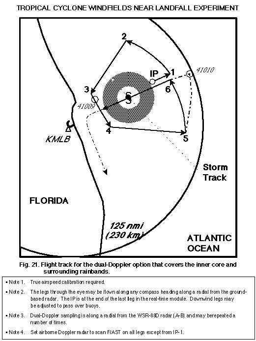
In the example shown, this pattern could be flown in
about 2 h. Note that the legs outside the inner core should be flown with
the tail radar in F/AST mode because the drift angle would be smaller. In
the example the module concludes with a coastal-survey pass south along the
coast.
[Return to table of contents above]
Coastal Survey Option
When the hurricane is making landfall, this
module will provide information about the boundary layer in the onshore and
offshore flow regimes. The WP-3D would fly a coastal survey pattern
parallel to the coast, as close as safety permits, at 5,000 ft (1.5 km) or
less, and drop GPS-sondes on either side of the storm track, to sample both
onshore and offshore flow regimes (Fig. 22). The Doppler radar would be in
F/AST mode, to provide wind estimates on either side of the aircraft track.
This module could be flown when the hurricane is making landfall or after
the storm moves inland. The pattern could be flown in ~1 h. GPS-sonde drops
could be adjusted to be near surface platforms.

[Return to table of contents above]
Post-landfall Option
If the structure of the storm is such that
flight patterns at 10,000 or 15,000 ft (3.0 or 4.5 km) are feasible over
land, the pattern shown in Dual Doppler option 1 would be flown, except
that the storm would be followed inland as long as time and safety
considerations permit. It may be possible to fly the radial legs with the
radar in F/AST scanning mode depending on the location and status of the
WSR-88D.
[Return to table of contents above]
Back to the Tropical Cyclone Winds at Landfall
Experiment