Biscayne Bay Turbidity Baseline Project
![]()
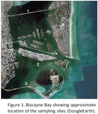
The Biscayne Bay Turbidity Baseline project will provide a data set of important physical and chemical oceanographic data from three sites the northern portion of the Biscayne Bay prior to the onset of proposed dredging operations. The sites are shown in Figure.1
The goal of the project is to quantify baseline turbidity conditions at these sites under varying environmental conditions that will allow for estimation of what turbidity conditions may be expected at these sites during the dredging operations. Measurements will be obtained for one year. The measurements will be obtained with sufficient frequency so that the impact of episodic events can be quantified. Site location was determined to comport with existing long-term data sets collected by Miami-Dade (DERM)1 and FIU2.

In-situ measurements will include chlorophyll-a, turbidity, temperature, chromophoric dissolved organic matter (CDOM), salinity, and ocean currents and acoustic backscatter via acoustic Doppler current profiler (ADCP). Calibrated light attenuation profiles will be obtained to estimate light attenuation continuously at the study sites. The light attenuation can then be compared with water depth to determine the amount of light reaching the bottom at the study site under different turbidity conditions and determine if it is sufficient for sea grass growth.3 A relationship between turbidity data recorded by the in situ and shipboard optical turbidity sensors with the acoustic backscatter data recorded at the same level in the water column will be calculated. This relationship will be used to qualitatively assess, via the acoustic backscatter, the vertical distribution of turbidity at the measurements sites and to assess the spatial variability of turbidity in the regions near to the measurement sites.4 Meteorological data will be used to examine the contribution of wind-driven turbidity to the overall turbidity regime. Electron scanning microscopy (SEM) and gravimetric analysis of water column samples will establish the relationship of turbidity with particle load, particle composition and particle size. Time-lapsed photographic images will record the visual signal of turbidity events in the regions of sites 2 and 3.
The project is scheduled to be completed in in June, 2011.
1. USACE. Miami Harbor Miami-Dade County, Florida Navigation Study, 2004.
2. Boyer, J. and H. Briceņo. South Florida Coastal Water Quality Monitoring Network. SFWMD, 2006.
3. Kelble, C.R., P. B. Ortner, G. L. Hitchcock, and J. N. Boyer. 2005. Attenuation of photosynthetically available radiation (PAR) in Florida Bay: Potential for light limitation of primary producers. Estuaries, 28(4):560-571 2005
4. Stamates, J. S. Estimation of suspended matter concentrations in an area of Chesapeake Bay using a calibrated acoustic Doppler current profiler. University of Miami Thesis, 2003, S783e.
![]()
Scientists and Support Staff
Principle Investigators: Jack Stamates, Chris Kelble, Thomas Carsey, Charles Featherstone
Scientific Support: Joseph Bishop, Cheryl Brown,
![]()
The Biscayne Bay Turbidity Baseline Project is a part of the Coastal Environment Group in the Ocean Chemistry Division of NOAA's Atlantic Oceanographic and Meteorological Laboratory.
