|
|
|
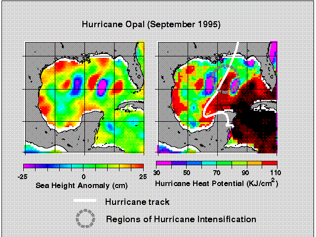
Altimetry and Hurricane Intensification: Upper Ocean Conditions in the Tropical Atlantic, Caribbean Sea and Gulf of MexicoBackground The intensification of hurricanes involves a combination of different favorable atmospheric conditions such as atmospheric trough interactions and vertical shear, which lead to good outflow conditions aloft. As a result of this, inflow conditions in the near-surface layer are enhanced. Clearly, as this process continues over the scale of the storm, the upper ocean provides the heat to the atmospheric boundary layer and the deepening process. In this scenario, the upper ocean thermal structure has been thought to be a parameter that only played a marginal role in hurricane intensification. However, after a series of events where the sudden intensification of hurricanes occurred when their path passed over oceanic warm features, it is now being speculated that it could be otherwise. While the investigation of the role of these rings and eddies is a topic of research in a very early stage, preliminary results have shown their importance in the intensification of hurricane Opal (Shay et al, 2000). Therefore, the monitoring of the upper ocean thermal structure has become a key element in the study of hurricane-ocean interaction with respect to the prediction of sudden hurricane intensification. These warm features, mainly anticyclonic rings and eddies shed by the Loop Current, are characterized by a deepening of several tens of meters of the isotherms towards their centers and with different temperature and salinity structure than the surrounding waters. The specific research objectives of this work include to determine the location and hurricane heat potential of warm core rings, Florida Current and the Gulf Stream, and to examine the forcing by warm ocean features on surface stresses. To achieve these objectives this research is developing both an active ocean monitoring program based on altimeter techniques to detect warm mesoscale ocean features, and in situ oceanic and atmospheric sampling component from the NOAA WP-3D in collaboration with NOAA/AOML HRD scientists. The research effort addresses specific objectives of the NSF/NOAA United States Weather Research Program. Hurricane Opal
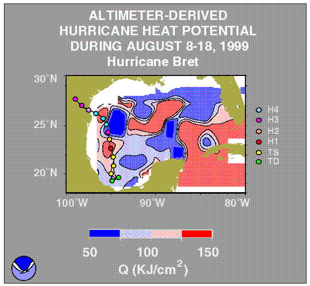
Hurricane Bret
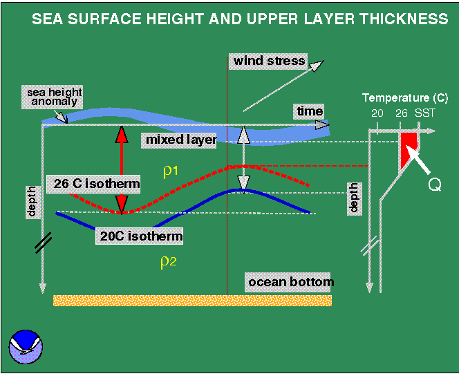 The close relationship that exists between
the dynamic height and the ocean mass field allows these two
parameters to be used within a two-layer reduced gravity ocean model
to monitor the upper layer thickness (Goni et al., 1996), which is
defined in this study to go from the sea surface to the depth of the
20C isotherm (Figure 2) This isotherm is chosen because it lies within
the center of the main thermocline and is often used as an indicator
of the upper layer flow in the western tropical Atlantic and Gulf of
Mexico waters. Although there are other factors controlling the sea
height anomaly, it is assumed here that most of its variability is due
to changes in the depth of the main thermocline and of barotropic
origin. The hurricane heat potential, Q, is defined here as a measure
of the integrated vertical temperature from the sea surface to the
depth of the 26C isotherm. This parameter is computed from the
altimeter-derived vertical temperature profiles estimates in the upper
ocean. The temperature profiles are estimated using four points: (a)
the sea surface temperature obtained from the Reynolds near real time
weekly fields, (b) the altimeter-estimates of the 20C isotherm within
a two-layer reduced gravity scheme (Goni et al, 1996), (c) the depth
of the 26C isotherm from a climatological relationship between the
depths of the 20C and 26C isotherm, (d) climatological estimates of
the mixed layer depth.
The close relationship that exists between
the dynamic height and the ocean mass field allows these two
parameters to be used within a two-layer reduced gravity ocean model
to monitor the upper layer thickness (Goni et al., 1996), which is
defined in this study to go from the sea surface to the depth of the
20C isotherm (Figure 2) This isotherm is chosen because it lies within
the center of the main thermocline and is often used as an indicator
of the upper layer flow in the western tropical Atlantic and Gulf of
Mexico waters. Although there are other factors controlling the sea
height anomaly, it is assumed here that most of its variability is due
to changes in the depth of the main thermocline and of barotropic
origin. The hurricane heat potential, Q, is defined here as a measure
of the integrated vertical temperature from the sea surface to the
depth of the 26C isotherm. This parameter is computed from the
altimeter-derived vertical temperature profiles estimates in the upper
ocean. The temperature profiles are estimated using four points: (a)
the sea surface temperature obtained from the Reynolds near real time
weekly fields, (b) the altimeter-estimates of the 20C isotherm within
a two-layer reduced gravity scheme (Goni et al, 1996), (c) the depth
of the 26C isotherm from a climatological relationship between the
depths of the 20C and 26C isotherm, (d) climatological estimates of
the mixed layer depth.
What do these maps mean ? The sea height anomaly represents the deviation of the sea height with respect to the 1993-1997 mean. For analysis and corrections of altimeter data, please refer to: Cheney et al, TOPEX/POSEIDON: The 2-cm Solution, J. Geophys. Res., 99, 24555-24564, 1994. The upper layer thickness is the altimeter estimate of the depth of the 20C isotherm (Goni et al., 1996). The hurricane heat potential, is a measure of the integrated vertical temperature between the sea surface and the estimate of the 26C isotherm (Shay et al., 2000). What can these maps be used for ? These maps can be used to identify warm anticyclonic features, usually characterized by sea height anomalies and upper layer thickness larger than their surrounding waters, and to monitor regions of very high (larger than 90 KJ/cm-2) hurricane heat potential. These regions have been associated with the sudden intensification of hurricanes. Acknowledgements The sea height anomaly fields are provided by Dr. Robert Cheney (NOAA/NESDIS). The Reynold's sea surface temperature weekly fields are provided by NOAA/NCEP. A Note on POSEIDON cycles POSEIDON shares the same antenna as TOPEX, thus only one altimeter operates at any given time. During 2000 POSEIDON will be on for cycles 278 (Mar 31 - Apr 10, 2000), 289 (Jul 18 - Jul 28, 2000) and 295 (Sep 16 - Sep 26, 2000) and near-real time data will not be available during these periods. The maps shown during these periods correspond to the latest TOPEX available data and the current SST fields. The Hurricane Heat potential fields are computed from these two data fields. References Goni, G. J., Kalmholz, S., S. Garzoli and D. Olson, 1996. Dynamics of the Brazil-Malvinas Confluence Based on Inverted Echo Sounders and Altimetry, J. Geophys. Res., 101, 16273-16289. Shay, L. K., G. J. Goni, and P. G. Black, 2000. Effect of a Warm Ocean Ring on Hurricane Opal. Mon. Weath. Rev., 128, 1366-1383. This research is funded by ONR (CBLAST Program) and NOAA. |
Please address your questions or comments about these maps to Gustavo Goni
W3 development by Joaquin A. Trinanes