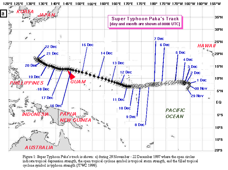
Paka's genesis occurred in the central Pacific Ocean
during late November 1997, which is near the end of the official
central Pacific hurricane season (NOAA 1998a). The tropical
cyclone's track across the Pacific Ocean is shown in
Fig. 1a. The strong El Nino
Southern Oscillation (ENSO) event, which began earlier in 1997,
was well underway at the time of Paka's formation. An equatorial
westerly wind burst southwest of Hawaii led to the formation of
twin tropical cyclones: Paka north of the equator and Pam to the
south (JTWC 1997). The tropical depression which later became
Paka formed on 28 November 1997 and was officially declared a
tropical storm by the Central Pacific Hurricane Center (CPHC) at
1200 UTC 2 December. Pam became a southern hemisphere tropical
cyclone on 6 December and moved toward the south and southeast
before weakening to a tropical depression over the south Pacific
Ocean on 10 December (personal communication, G. Padgett 1998). Paka
crossed the International Dateline on 6 December and eventually
strengthened to a tropical storm with 31 m s-1 (60 kt) sustained
winds, before weakening on 8 December. The tropical storm moved into
the Federated States of Micronesia on 11 December and strengthened
to a typhoon. Typhoon Paka's winds increased to 59 m s-1 (115 kt) on
12 December, but later weakened as its forward motion increased.
The typhoon raced westward at 8 m s-1 (16 kt) toward the southern
Marshall Islands.
A typhoon watch was issued by the NWSFO, Guam, at
2300 UTC 14 December for the Marshall Islands when Paka was over
1200 km (650 nm) east-southeast of Guam. The watch was upgraded to a
typhoon warning for Guam, Rota, Tinian, and Saipan at 1530 UTC 15
December [at the same time that Paka was upgraded to a super typhoon
with sustained winds of 72 m s-1 (140 kt)]. As Paka approached Guam
and Rota, its sustained winds decreased to 64 m s-1 (125 kt) and
its forward motion slowed to 5 m s-1 (9 kt). However, during its
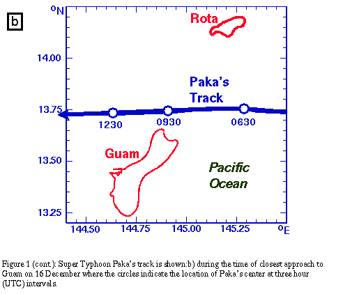
closest approach to Guam (Fig. 1b),
the typhoon intensified to 67 m s-1 (130 kt), while its forward
motion slowed to 3 m s-1 (6 kt). Paka continued to intensify
after leaving the Marshall Islands and its winds reached maximum
1-min sustained values of 82 m s-1 (160 kt) on 18 December. Later
the typhoon weakened rapidly and completely dissipated by 22
December.
Typhoon Paka's strong winds over the northern two-thirds of
Guam resulted in significant damage and also caused the loss of most
wind observation and recording equipment on the island [e.g., the
Apra Harbor Handar, the National Ocean Service (NOS) Next Generation
Tide gage (NGTG), etc.]. Other failures of wind instruments
occurred when power sources failed during the typhoon. For example,
wind-driven rain in Paka's outer eyewall caused the loss of power to
the generator supplying power to the Andersen Air Force Base (AAFB)
FMQ-13 "hot-film" wind measuring instrument and the Automated
Surface Observing System (ASOS) located at the Guam NWSFO. The
location of the equipment that recorded wind data on Guam during
Paka is shown in Fig. 2.
The NPDAT visited Guam during 22 - 26 December 1997 to collect
all available meteorological data (primarily wind data). In addition
to data collection, visits were made to all wind observing sites to
document anemometer height, local terrain, exposure, proximity to
buildings or vegetation, and other factors that might affect the
wind measurements as a function of azimuth. The sites visited and
the status of the wind observation records are listed in
Table 1.
Examples of some wind observation sites visited and documented
are provided in Appendix B. Time-series of all available wind and
pressure data are provided in Appendix C. The data from the various
wind measurement sites were examined closely, because each location
had unique characteristics and a variety of wind instruments. Some
wind observations were compared with those made by official
observing equipment that have known measurement standards, heights,
averaging times, exposures (i.e., marine or over land) and local
terrain effects. Two types of instruments, ASOS and NGTG, have
provided high wind measurements in tropical cyclones at other
locations in the past. For example, wind speed measurements in
excess of 50 m s-1 (97 kt) were made before the power failed to the
ASOS on St. Thomas, U.S. Virgin Islands in Hurricane Marilyn of 1995
(Powell and Houston 1998, hereafter referred to as PH98). Also
National Ocean Service (NOS) Next Generation Tide Gages (NGTG)
measured high winds in Hurricane Andrew's (1992) south Florida
landfall (Powell and Houston 1996, hereafter referred to as PH96)
and Hurricane Opal's (1995) landfall in north Florida described by
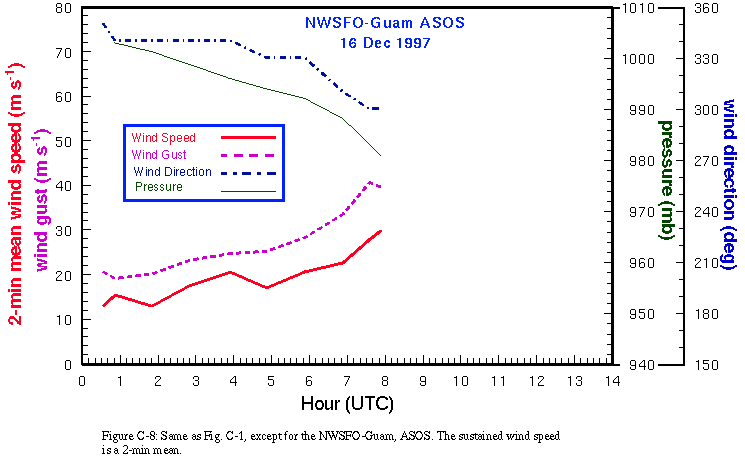
PH98. The Guam ASOS and NGTG wind observation records were of
relatively short duration and ended prior to the peak winds in Paka.
They were compared with nearby stations that had longer records to
determine how reliable the observations were until the time they
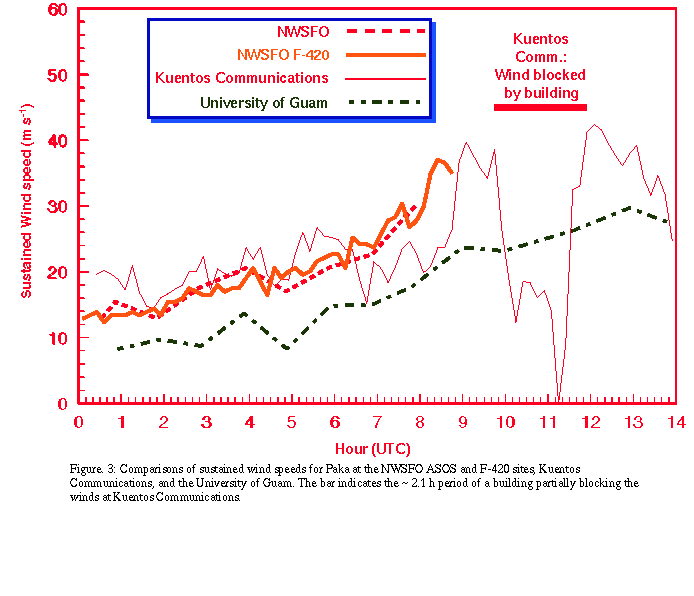
failed. Figure 3 shows comparisons
between the Guam ASOS and the NWSFO F-420 wind measuring
equipment at the Guam International Airport. Also, the ASOS winds
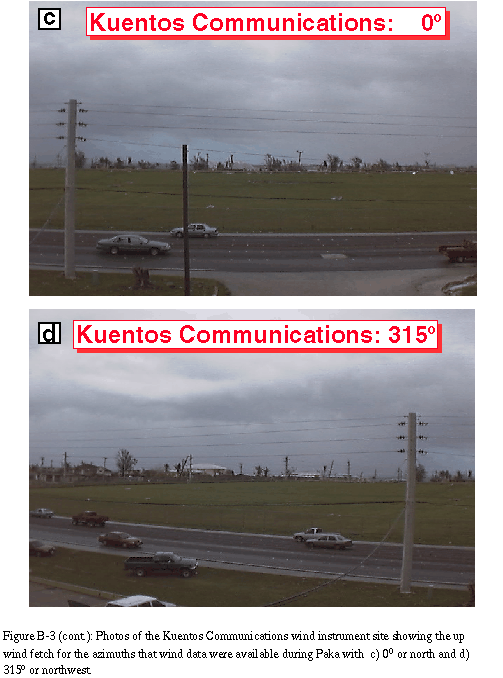
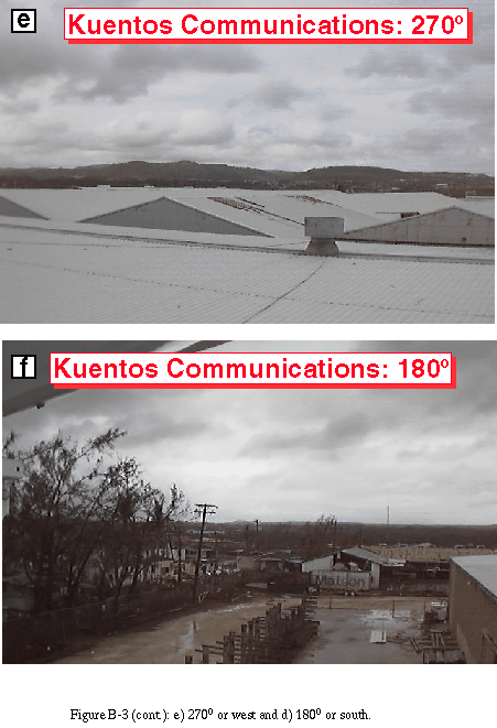
were compared with the wind record from an amateur station at
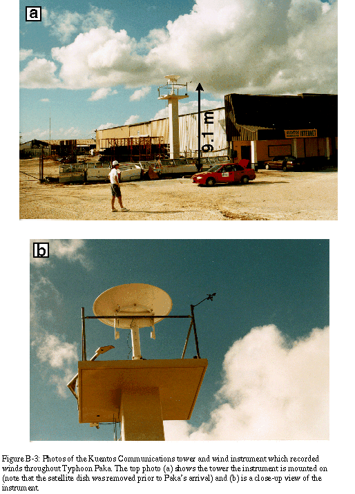
Kuentos Communications, Inc. (KCI) in
Fig. 3. A similar amateur wind
measurement system measured the highest surface wind gust during
Hurricane Andrew's south Florida landfall according to PHR. These
comparisons indicated that both of these instruments had reliable
wind observations while the ASOS was operating (the power failed
to ASOS after 0753 UTC and the F-420 was destroyed after 0845
UTC). The KCI system had a complete wind record throughout the
typhoon, although it suffered from approximately 2 h of
significant blockage of the wind by an adjacent building. This
limited the usefulness of the entire wind record at KCI, although
the portion of the wind record from the south after 1200 UTC was
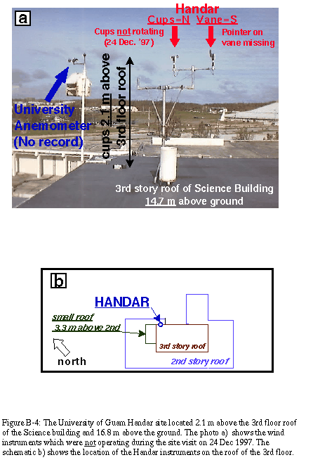
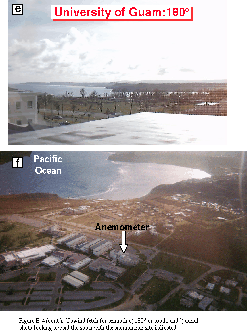
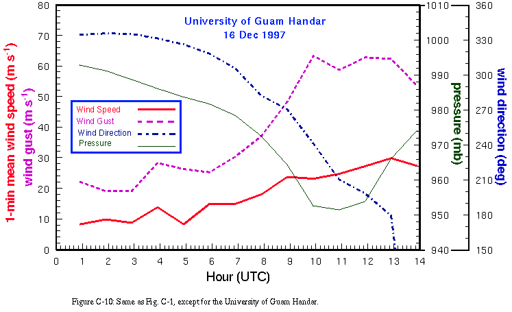
considered reliable. The Guam University Handar site was slightly
further away from the ASOS than the KCI site. The sustained wind
speeds at the Guam University site were always lower than the
ASOS winds. After the ASOS failed, the winds at this site were
still low, even when the southerly wind exposure would have had
an over water fetch after Paka's center passed northwest of the
island. When this site was visited on 23 December, the anemometer
cups were not rotating despite wind speeds estimated at 5-10 m s-1.
The anemometer may have been failing on 16 December. For example,
the gust factors at the Guam University were extremely large
(ranging from 1.7 to over 3.0). The cups were possibly responding to
brief strong wind gusts, but may have rotated so slow that the
1-min mean observations were underestimated. The gusts recorded at
the Guam University site were considered reasonable values when
compared with the other sites and an appropriate gust factor could
be applied to estimate the maximum 1-min sustained wind from these
wind gusts.
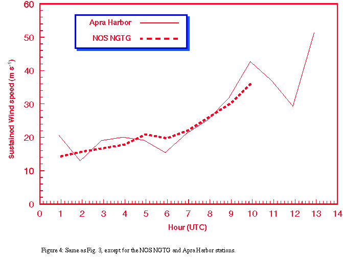
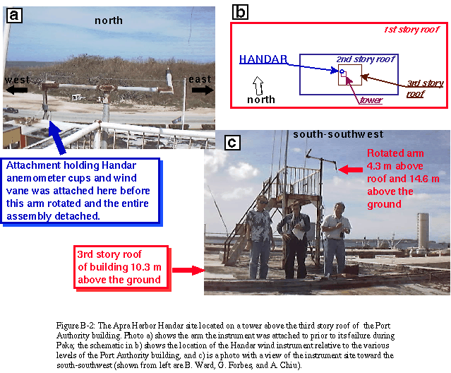
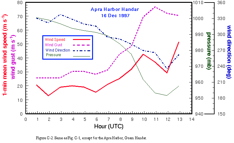
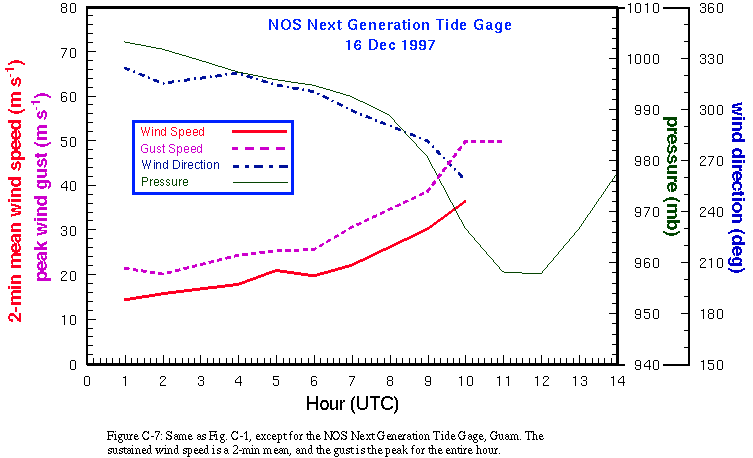
The close proximity and marine exposure of the NOS NGTG and
Handar sites located at Apra Harbor provided very useful comparisons
(Fig. 4) during the onset of Paka's
outer eyewall winds. The NOS NGTG failed after 1000 UTC and the
Apra Harbor Handar instrument failed after 1250 UTC. The NGTG
wind speeds were similar to those at the Handar site, even though
the Handar site was located on a building 14 m above the ground
with marine exposure from the north and northwest. The wind gusts
from the Handar site were greater than those at the NGTG site.
The Apra Harbor Handar site also had some spurious wind gusts
that were too high to be considered real wind speeds (Guard 1998)
prior to the destruction of the instrument after 1250 UTC (these
recorded wind gusts may have been the result of spurious signals
due to electronic noise as Paka's wind began to destroy the
Handar instruments).
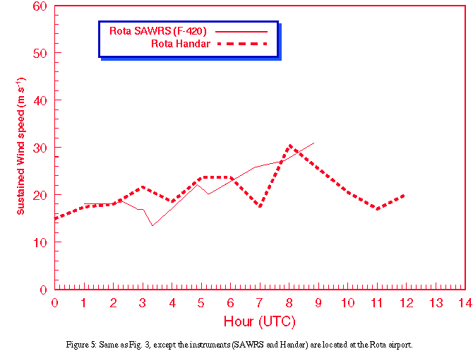
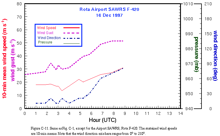
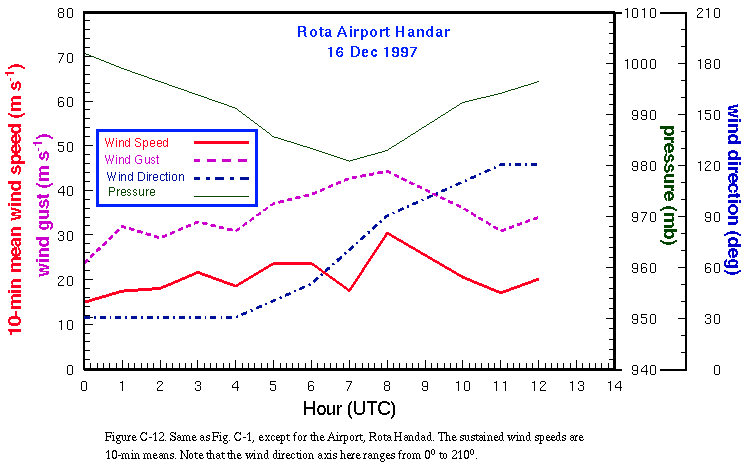
Observations were also available from Rota's airport at a
Handar instrument and a SAWRS site using an F-420 wind instrument.
The observations from these two instruments were compared for the
period that data were available (Fig.5).
The SAWRS station at the Rota airport closed after 0850 UTC, so
the primary surface data source during Paka's peak winds over
Rota was the Handar site (the last observation available from
this site was at 1200 UTC after the winds began to decrease).
Note that the sustained winds and gusts recorded here were much
weaker throughout the storm than those observed on the left side
of the hurricane over Guam. This was likely due to the distance
the island was from Paka's track
(Fig.1b).
The Guam WSR-88D was repaired and became operational on 15
December prior to the arrival of Paka's outer eyewall over extreme
northern Guam (NOAA 1998a). The WSR-88D has the ability to store
data as Level II or Level IV products (Crum et al. 1993). One of the
best tropical cyclone data sets ever captured in digital form would
likely have been available if the Level II data recorder had
functioned properly during Paka's passage over Guam. However, this
system failed completely and the power to the WSR-88D also failed
after 0721 UTC. Fortunately, the Level IV images and data were
available and recorded at 4 locations (AAFB, Guam NWSFO, JTWC, and
CPHC). The JTWC provided these Level IV data to the NWS Operational
Support Facility (OSF) and the NPDAT. The Tropical Prediction Center
(TPC) provided the resources necessary for the NPDAT to access
these data.
The WSR-88D reflectivity data defined the concentric eyewall
pattern that existed during Paka's approach to Guam and the outer
eyewall's crossing of the island's northern coastline (see Appendix
D). The track of the typhoon's center was also available from these
data. The most important quantity available from the Guam WSR-88D
Level IV data were the Doppler winds. Images of the high-resolution
radial wind velocities were available at approximately 6 min
intervals for the 1.5o tilt (high-resolution 0.5o tilt data are not
available on Guam due to beam blockage from a tall residential
building that was constructed after the WSR-88D became operational).
Doppler velocities (VD) from the WSR-88D were not easily used
in constructing two-dimensional surface wind fields. Two-dimensional
surface wind fields in tropical cyclones can not be easily
constructed using VD data from a single WSR-88D. Therefore, it was
necessary to use a technique for single ground-based radar wind
retrieval. Appendix D contains details about the Ground Based
Velocity Track Display (GBVTD) used for producing two-dimensional
surface wind fields based on the Guam WSR-88D VD.
All wind observations that were representative of Super Typhoon
Paka's winds over Guam and Rota, including data from anemometers
and the Guam WSR-88D derived GBVTD winds, were assimilated using
analysis techniques developed in the reconstruction of Hurricane
Andrew's wind field (PHR; PH96). The surface wind observations were
composited relative to the tropical cyclone's circulation center
over a 3-6 h period of the storm's movement after being processed to
conform to a common framework for height (10 m), exposure (marine
or open-terrain over land), and averaging period (maximum 1-min
sustained wind speed) using the methods of PHR. In recent years,
these types of analyses have been made available to the forecasters
at the National Hurricane Center (NHC) /Tropical Prediction Center
(TPC) on an experimental basis, including the extremely active 1995
Atlantic basin hurricane season (PH98).
All wind observation sites on Guam were visited and
documented (for some examples, see Appendix B). The characteristics
of each site were used to adjust the reliable wind observations to a
common framework of height and time. The adjustment of the
available surface wind observations to 10 m was difficult in some
cases, because of the rugged terrain and sharp rise of the land from
sea-level to an escarpment along many portions of Guam's coastline
(e.g., JTWC's wind record). These local conditions probably result
in unusual local wind effects, such as those that were experienced
in tropical cyclones effecting Caribbean islands having sharp
coastal relief and rugged topography (e.g., Hurricane Marilyn of
1995 in the U.S. Virgin Islands documented by PH98).
After all of the surface wind data were adjusted to a common
framework and quality controlled, they were processed in a nested,
scale-controlled objective analysis package (Ooyama 1987; Franklin
et al. 1993). The resulting product was a gridded wind field which
was displayed as surface wind observations used in the analyses
were considered to be epresentative of open-terrain over-land
exposures at 10 m.
Therefore, winds experienced at sea and along the immediate
coastline of Guam may have been much higher. Likewise, winds in
locations sheltered by topographic features would likely have been
overestimated, while areas with "speed up" effects due to flow over
topography or channelization of flow would likely have received
higher 1-min sustained wind speeds.
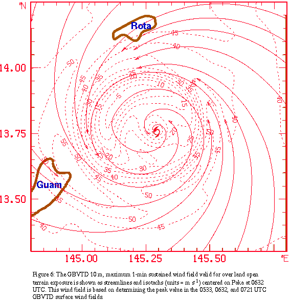
The analyses for Paka were centered at 0630 UTC, 0930 UTC, and
1230 UTC. The 0632 UTC GBVTD 10 m, maximum 1-min sustained wind
field (Fig. 6) created using the
methods described in Appendix D was used as a background field
for the surface wind analysis. These surface wind analyses are
shown as snapshots in Figs. 7 (0630 UTC),
8 (0930 UTC), and 9 (1230 UTC). These analyses were projected along
the track in Fig. 1b to construct
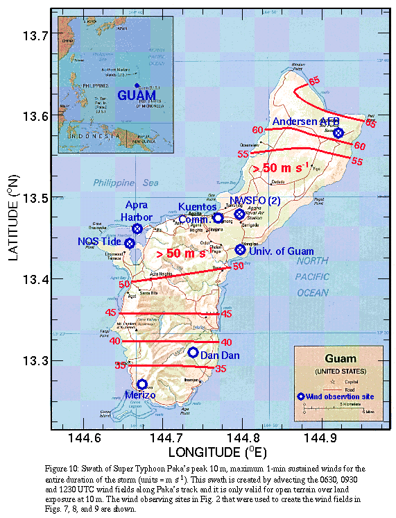
a swath of peak values of maximum 1-min sustained winds (Fig. 10). The winds were in excess of 50 m
s-1 over much of the northern two-thirds of Guam and and values of
up to 65 m s-1 occurred over the extreme northeastern tip of the
island near AAFB. Winds of at least typhoon force (maximum 1-min
sustained winds of at least 34 m s-1) occurred for over 8 h across
some of the northern portions of the island. This would have most
likely occurred in those areas which remained in the outer eyewall
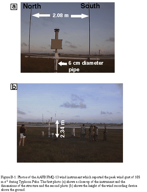
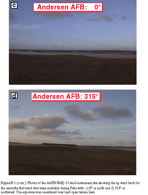
throughout Paka's closest approach to Guam. AAFB did experience some
of the weaker winds associated with the "outer eye" according to
Dominguez et al. (1998), so the duration of typhoon force winds here
was less than 8 h. Most of the southern portion of Guam north of
Merizo with open terrain over land exposure at 10 m had typhoon
force winds for at least one hour. In reality, the sheltering
effects of the varying topography here would like have limited the
duration of typhoon force winds observed.
Despite the loss of all official wind recording equipment
on the northern portion of Guam (one amateur wind record was
available throughout the event), wind fields were produced for Super
Typhoon Paka's passage over the island. This was made possible by
the use of GBVTD to produce wind fields based on the Guam WSR-88D
Level IV VD's prior to the loss of power at the radar. The wind
fields for open terrain over land exposure look reasonable (prior to
1200 UTC) when there was a wider distribution of reliable surface
wind observations. Although sustained winds over a small area of
extreme northern Guam may have been in excess of 65 m s-1, these
winds were not representative of the areas south of AAFB. The
duration of typhoon force winds was greater than 8 h across some
populated regions (> 7 h over most of the northern two-thirds of the
island). This long period of strong winds and the wind direction
shifts (> 180o) that occurred as the typhoon's eyewall moved over
the island likely contributed to much of the observed damage. In
addition, the extended period of strong winds and the report of the
extreme wind gust at AAFB, which was determined by the NPDAT to be
unreliable based on the evidence gathered (Appendix E), likely led
to the perception that Paka was much more severe than it was in
reality.
The loss of valuable data, such as the wind data from the
ASOS at the Guam WSFO and the loss of the Archive II data record
from the Guam WSR-88D, is considered to be unacceptable by the
NPDAT. This is a recurring problem in recent tropical cyclone
landfalls. As the United States, through efforts of agencies such as
the Federal Emergency Management Agency (FEMA), moves toward a more
aggressive policy of mitigating disasters, it is essential to have
accurate and reliable wind measuring systems which can provide
engineers with the data they need in their efforts to improve
structural resistance to wind forces. Whenever any official system
that measures data that are considered essential for quantifying the
destructive characteristics of a storm is installed, storm data
acquisition should be a primary concern. These observing systems
need to be ruggedized, have uninterrupted power sources, and
adequate data storage and retrieval systems for access by local
officials and those charged with post-storm service assessment and
data acquisition. If only a few official systems on Guam had
recorded data throughout Paka, many of the questions about the
nature of Paka's destructive wind field could have been answered by
the NPDAT immediately. Instead, the team was forced to rely on data
recorded by non-standard equipment (including a complete record from
an inexpensive amateur weather system with back up power),
low-resolution Level IV WSR-88D products, and visual inspection of
the damage.
AAFB wind instrument
AAFB site exposure
AAFB aerial view
Apra Harbor Handar site
KCI tower instrument
KCI tower N & NW exposure
KCI tower W & S exposure
University of Guam
instrument
University of Guam N & W
exposure
University of Guam S
exposure and aerial view
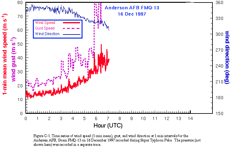
AAFB wind trace
Apra Harbor Handar wind trace
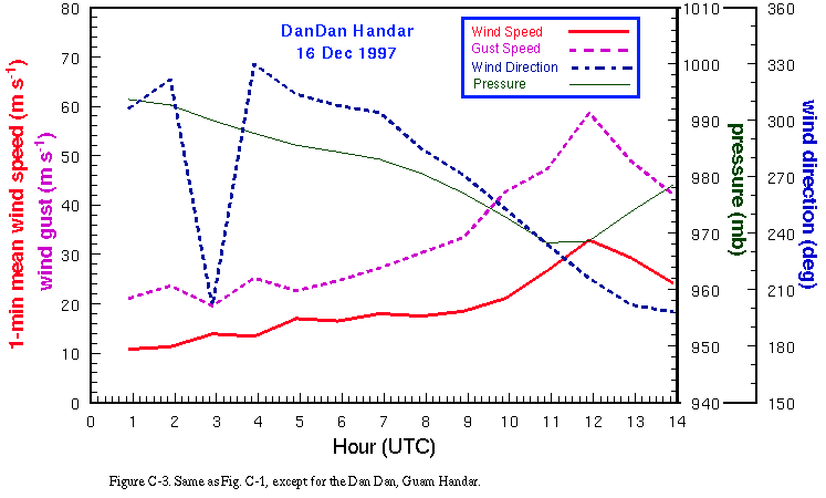
Dan Dan, Handar wind trace
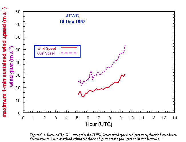
JTWC, Guam wind trace
KCI tower wind trace
Merizo, Guam wind trace
NOS Tide Guage wind trace
ASOS NWSFO, Guam wind trace
F-420 NWSFO, Guam wind trace
University of Guam, Handar wind trace
Airport SAWRS, Rota wind trace
Airport, Rota wind trace
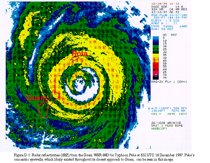
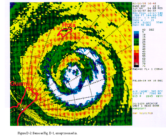
Figures D-1 and D-2 show the radar reflectivities from the Guam WSR-88D at 0632 UTC. Paka's concentric eyewalls are evident, even though the convection in the inner eyewall does not completely surround the eye. The outer eyewall moved over most of the northern portion of Guam and was associated with heavy rain and high winds (over 8 h in some locations).
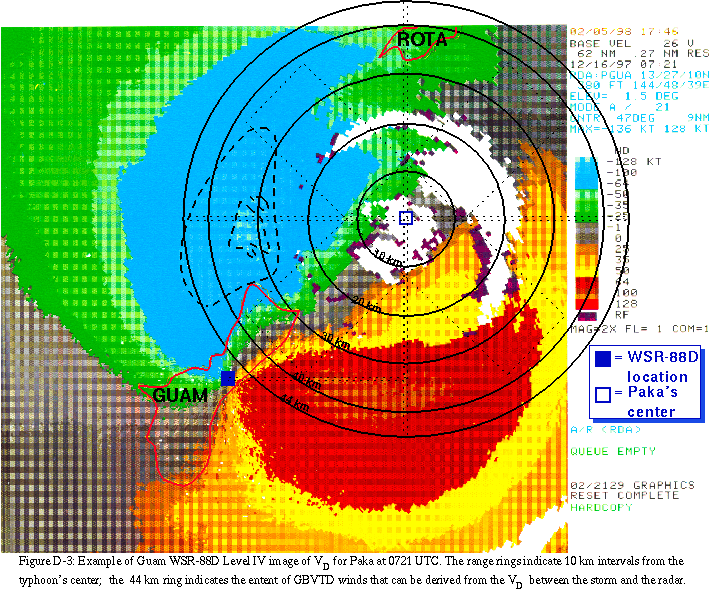
The GBVTD technique developed by Lee et al. (1998) was
used to retrieve wind observations from the Guam WSR-88D Archive IV
data. This method uses least squares methods to fit the primary
tropical cyclone circulation onto the Doppler velocities on series
of rings (Fig. D-3), each having
a constant radius from the tropical cyclone center. The mean
velocity (VM), which is the component of the mean wind along the
line joining the radar and the storm center, in addition to the
symmetric radial (VR) and tangential (VT) wind components are
retrieved for each radius. The asymmetric radial flows and the
cross-beam VM are not resolved, but are instead aliased into the
tangential winds. The GBVTD technique retrieves wind maxima that
are not directly observed (i.e., the velocities perpendicular to
the beam), because the GBVTD technique uses the Doppler velocity
gradient, not the observed maxima to retrieve wind maxima. In the
Lee et al. (1998) study, the GBVTD method retrieved good total
wind in nearly all cases tested.
In the case of the Guam WSR-88D data for Paka, Doppler
velocities were digitized manually from Level IV products for the
1.5o tilt at 0533, 0632, and 0721 UTC (
Fig. D-3) on 16 December. The GBVTD technique was applied to
the VD for each time. The GBVTD winds were assumed to be
representative of mean boundary layer winds even though they
ranged in height from 650 m to over 3000 m at radii ranging from
4 to 75 km, respectively. The GBVTD wind data for each time were
adjusted to 10 m and maximum 1-min sustained surface winds and
were used to create a background field for use in the surface
wind analyses. These winds were first adjusted to 10 m based
on the methods described by PHR. The gust factors used for the
adjusted GBVTD winds were based on the volume of atmosphere that
WSR-88D Doppler data were sampling. The major contribution to the
WSR-88D VD is the horizontal component of the wind. Therefore, the
horizontal area of each WSR-88D VD sample was used for estimation of
a gust factor for the VD (the horizontal area varies from 66 to
1243 m2 at 4 to 75 km, respectively, radius from the WSR-88D). The
sizes of these areas yielded averaging times that were > 1-min. The
gust factor described by PHR was applied to each GBVTD wind field to
adjust it to maximum 1-min sustained values at 10 m height. Once
this was done for each time, the peak value of the wind at each grid
point in the 10 m, maximum 1-min sustained GBVTD wind field
centered on Paka was chosen to produce the final GBVTD field
centered at 0632 UTC (Fig. 6). This
wind field was then used as the background for the surface wind
analyses.
In regards to the recorded wind gust of 205 knots (i.e., 236 miles
per hour) during Typhoon Paka at Andersen AFB on 16 December 1997,
based on the entire wind record at the site, Guam WSR-88D data, a
site survey, and ground and aerial damage assessments, we consider
the peak gust to be unreliable.
--- 23 February 1998
NOAA Typhoon Paka Data Acquisition Team:
The Super Typhoon Paka (1997) post storm data acquisition could not have been completed by the NPDAT without the assistance of the local officials, some of whom were only beginning to recover from the typhoon's effects on their own personal property and lives. In particular, the staff of the Guam National Weather Service Forecast Office and the Joint Typhoon Warning Center were extremely helpful during and after the NPDAT's visit. In addition, NOAA's Paka Service Assessment Team assembled on Guam aided the efforts of the NPDAT considerably. Coordination of the efforts between these two Teams, which have complementary missions, in future post-storm events should be considered a priority.
Crum, T. D., R. L. Alberty, and D. W. Burgess, 1993: Recording,
archiving, and using WSR-88Ddata.
Bull. Amer. Meteor. Soc., 74, 645-653.
Dominguez, R. and staff, 1998: Events log for Super Typhoon Paka, Weather Office, AAFB, 5 pp.
Franklin, J. L., S. J. Lord, S. E. Feuer, and F. D. Marks, 1993: The kinematic structure of Hurricane Gloria (1985) determined from nested analyses of dropwindsonde and Doppler data, Mon. Wea. Rev., 115, 2433-2451.
Guard, C. P., 1998: A preliminary assessment of the maximum wind speeds associated with Typhoon Paka over Guam. University of Guam, Mangilao, Guam, 5 pp.
JTWC, 1998: A synopsis of Super Typhoon Paka, Joint Typhoon Warning Center, 9 pp
Lee, W., B. Jou, P. Chang, and S. Deng, 1998: Tropical cyclone structure retrieved from single Doppler radar observations. Part I: Interpretation of Doppler velocity patterns and the GBVTD technique on analytic tropical cyclones, Mon. Wea. Rev., (Accepted for publication).
NOAA, 1998a: Super Typhoon Paka service assessment report. NOAA, 25 pp.
NOAA, 1998b: Super Typhoon Paka data acquisition team report. NOAA, (In preparation).
OFCM, 1997: The National Post-Storm Data Acquisition Plan (Draft). Office of the Federal Coordinator of Meteorological Services and Supporting Research, Silver Spring, MD, 51 pp.
Ooyama, K. V., 1987: Scale controlled objective analysis, Mon. Wea. Rev., 115, 2479-2506.
Powell, M. D., 1980: Evaluations of diagnostic marine boundary layer models applied to hurricanes, Mon. Wea. Rev., 108, 757-766.
Powell, M. D., 1993: Wind measurement and archival under the Automated Surface Observing System (ASOS): User concerns and opportunity for improvements. Bull. Amer. Meteor. Soc., 74, 615-623.
Powell, M. D., S. H. Houston, and T. Reinhold, 1996: Hurricane Andrew's landfall in south Florida, Part I: Standardizing measurements for documentation of surface wind fields, Wea. Forecasting, 11, 304-328.
Powell, M. D., and S. H. Houston, 1996: Hurricane Andrew's landfall in south Florida, Part II: Surface wind fields and potential real-time applications. Wea. Forecasting, 11, 329-349.
Powell, M. D., and S. H. Houston, 1998: Surface wind fields of 1995 Hurricanes Erin, Opal, Luis, Marilyn, and Roxanne at landfall. Mon. Wea. Rev., 126, 1259-1273.