TROPICAL CYCLONE WINDFIELDS AT LANDFALL FROM AIRBORNE AND LAND-BASED DOPPLER
RADAR DATA
Principal Investigator:
Peter Dodge
Sam Houston
Collaborating scientist(s):
Dr. Frank Marks, Jr.
Objective: Analyze the three-dimensional
wind structure of landfalling tropical cyclones by combining airborne Doppler
radar data collected by NOAA research aircraft with Doppler data archived
by National Weather Service WSR-88D coastal radars.
Rationale: NOAA has installed land-based Doppler
(WSR-88D) radars along the coast of the continental US. The WSR-88D's measure
only one component of the wind, towards or away from the radar. However,
if a NOAA P-3 flies an appropriate track relative to the hurricane and
WSR-88D, then data from the two platforms can be analyzed with dual-Doppler
algorithms to yield a time-series of three-dimensional wind fields. HRD
designed the Tropical Cyclone Windfields Near Landfall experiment, part
of the Hurricane Field Program, to gather flight-level wind data and make
surface wind estimates to improve real-time and post-storm surface wind
analyses in tropical storms and hurricanes (see REAL-TIME
HURRICANE DAMAGE MITIGATION). One of the objectives of this experiment
is to collect airborne Doppler radar data to combine with WSR-88D radar
data.
Method: If a tropical cyclone with sufficient
radar scatterers to define the vortex moves within 230 km (Doppler range)
of one or more WSR-88D radars, then a NOAA P-3 will fly on tracks defined
by the WSR-88D and the storm center. Because the airborne Doppler radar
scans in a vertical plane perpendicular to the aircraft track, the airborne
and land-based Doppler rays will be nearly orthogonal, optimal for dual-Doppler
analyses. During the storm, the WSR-88D will record base data. After the
storm HRD will obtain the WSR-88D data from the National Climatic Data
Center and process the Doppler data sets.
Accomplishment :
-
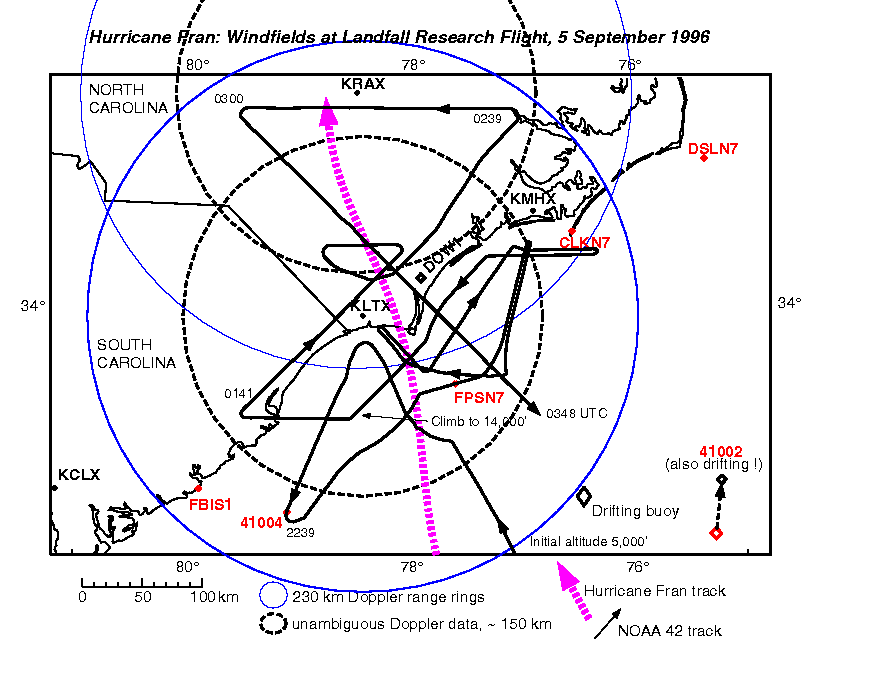
Hurricane Fran: Hurricane Fran (1996) was a category three hurricane
at landfall on 6 September 1996. The hurricane moved through a region covered
by several WSR-88D Doppler radars, with overlapping Doppler coverage (FIGURE
1). To supplement the marine surface stations, the US Air Force deployed
3 National Data Buoy Center drifting buoys ahead of the storm. The University
of Oklahoma sent a mobile Doppler radar (DOW1 ) to North Carolina to collect
data, and NOAA flew two research missions into the storm. The second P3
flight collected Doppler radar, scatterometer, and flight-level data for
the Tropical Cyclone Windfields at Landfall Experiment. A preliminary analysis
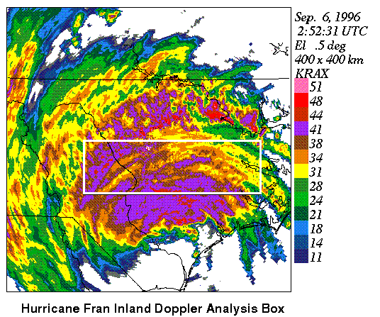
of the overland leg was constucted by combining Airborne Doppler radar
and WSR-88D data for a region 250 km long and 75 km wide. This comprised
a region of stratiform rain ~ 70 km north of Fran's center (FIGURE
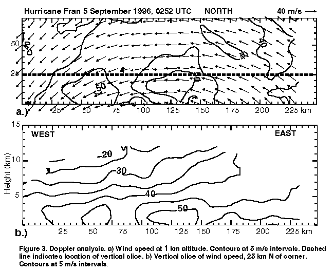
2). The winds at 1.0 km altitude were ~ 40 m/s in most of this region
(FIGURE 3a). An east-west vertical slice
through the horizontal wind maximum (FIGURE
3b) shows that the wind maximum appeared to be elevated at ~2 km in
the eastern part of the storm, but was nearer the surface in the western
half. Although some of this may be the result of the geometry of
the slice, it is also possible that this reflects boundary-layer processes
modifying the windfield as the air moves inland. A better understanding
will require further careful analysis of the Doppler data sets.
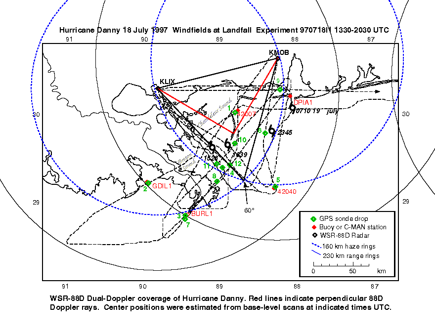
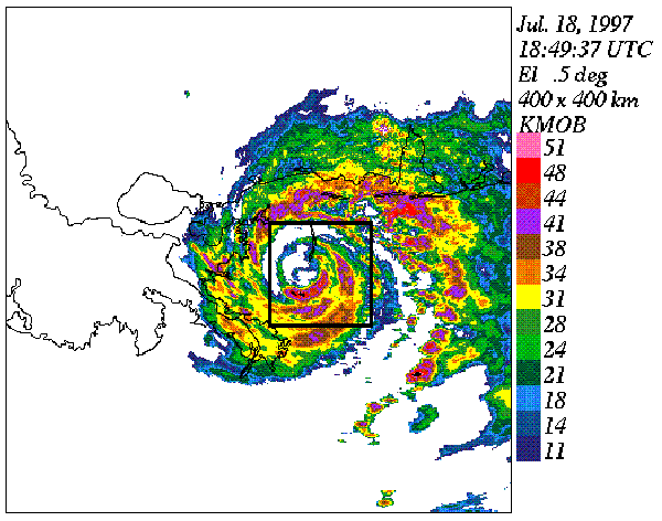
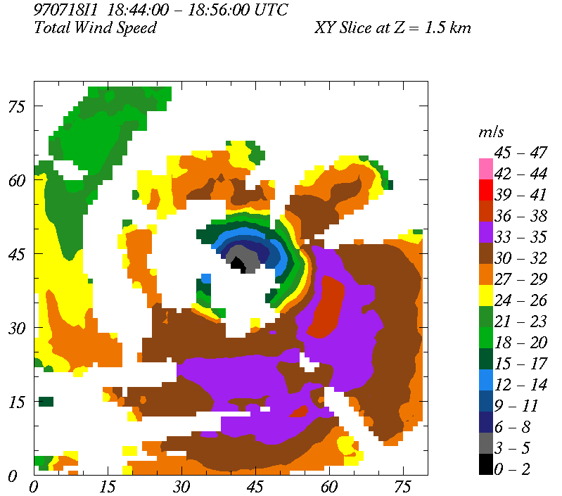
- Hurricane Danny: Hurricane Danny (1997), a category one hurricane,
also moved through a data-rich region (FIGURE
4). In addition to overlapping WSR-88D coverage, there are many surface
marine stations in the Gulf of Mexico. GPS sondes were dropped near several
of those to obtain boundary layer data in onshore and offshore flow. We
were especially interested in the onshore flow because of the possibile
storm surge in Lake Ponchatrain and Mobile Bay. The dBZ maximum in Danny
was on the south side (FIGURE
5). The winds were calculated on an 80x80 km domain centered on the
storm. This region was within the dual-88D coverage, although the 88D beams
were ~ 1.5 km high at these ranges. The additional airborne Doppler radar
data provide some additional details of the winds below that level. The
estimate of windspeed at 1.5 km (FIGURE
6) shows a large swath of winds > 30 m/s in the southern eyewall, with
embedded regions of winds > 35 m/s. The higher winds compare favorably
with the wind peak found in the last sonde drop. We plan to produce several
realizations of Danny's windfields with the multiple Doppler data.
Key reference:
Click here to return to the
AOML project overview page.
Last modified: 24 November 1997
Please report any problems to webmaster.