WIND FIELD AND REFLECTIVITY STRUCTURE AND EVOLUTION OF
HURRICANE OLIVIA ON 25 SEPTEMBER 1994
Principal Investigator:
John F. Gamache
Collaborating
scientist(s):
Hugh E. Willoughby
Christopher Samsury
DMichael Black
Frank D. Marks, Jr.
Peter G. Black
Objective:
To document the structure of Hurricane Olivia during the NOAA aircraft
research mission conducted on 25 September 1994. To document the evolution
of the wind field during the 3+ hours of airborne Doppler observations.
Rationale:
The two most important forecast parameters for tropical cyclones will be
the future positions of the hurricane (track) and how strong will the winds
be (intensity). To goal of the airborne mission was to document at 1/2 hour
resolution the changes in the tangential, radial and vertical winds, as well
as the precipitation structure and intensity, in the core of the storm.
During the on-station portion of the 25 September mission, Hurricane Olivia
underwent a dramatic reduction in the intensity of the upper half of the
storm, and the shear of the inner-core mean wind greatly increased. We
were very fortunate to arrive in the storm while it was highly symmetric and
to leave when it had become more asymmetric than most hurricanes. Although
the original intent of the eyewall evolution experiment did not have this
kind of storm in mind, it should help to illustrate the roles of shear and
changing sea-surface temperature.
Method:
Perform the analysis of wind speed and direction for each of the 7 "snapshots"
of the inner core wind field. Document the change with time in the wind
field. Note the relationship of wind and reflectivity to average shear of
wind within the storm core.
Accomplishment:
Very little new Doppler analysis was done on the 25 September case in FY1996,
but this page gives a flavor for the kind of data set we have built for this
day.
The analyses show that the overall reflectivity distribution changed
dramatically over the 3+ hour period
(Figure 1a and 1b).
The north-northeastward motion of the storm was carrying Hurricane Olivia
over a strong gradient in sea surface temperature, and toward the colder
water. The degree to which the increased shear in the storm results from
an approaching large scale shear zone, or it results from an internal
response to colder sea surface temperatures is unclear at this time.
The change in shear from the first of seven core wind analyses to the last
one can be seen in (Figure 2), .
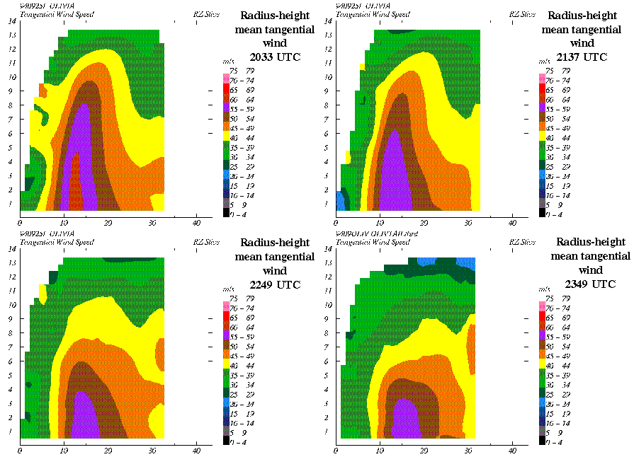
The intensity of the radius-height mean winds in the top half of the
storm decreased greatly, while the bottom half remained nearly unchanged,
as shown in Figure 3.
Last modified: 10/7/96