![]()


| Staff | Data Center | Contact Information |
|
Tropical cyclone wind radii estimation utilizing an empirical inland wind decay modelPrinciple Investigator:
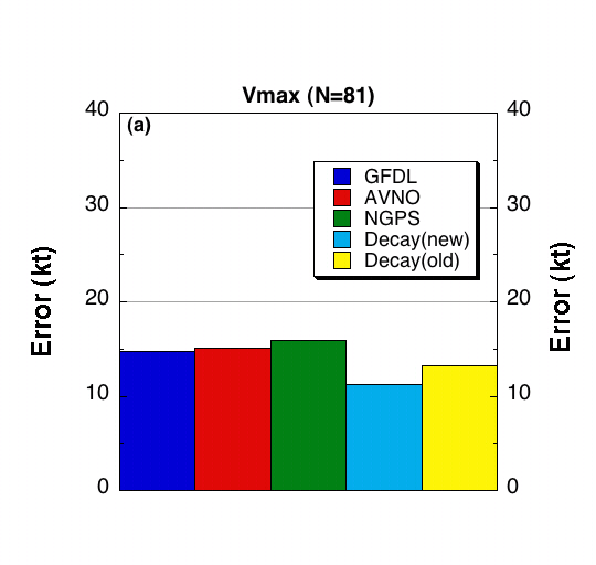
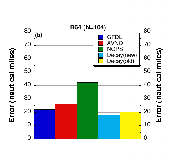
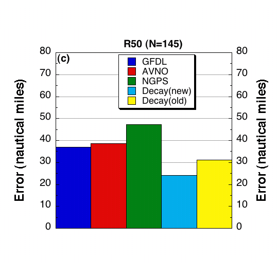
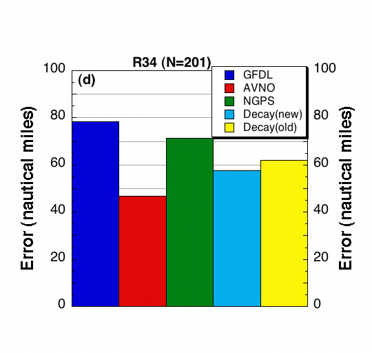
John Kaplan (HRD) Methodology The Tropical Prediction Center/National Hurricane Center (TPC/NHC) is required to issue forecasts of the radii of 34, 50, and 64 kt winds for tropical cyclones every 6 hours as part of their forecast/advisory package. However, little objective guidance exists for such forecasts, particularly for landfalling storms. Since several recent hurricanes have produced significant damage and loss of life inland due to high winds (e.g. Andrew (1992), Opal (1995), Isabel (2003), Charlie (2004), Frances (2004), Jeanne (2004), Katrina(2005)) the need for such guidance seems quite apparent. Consequently an empirical decay model (Kaplan and DeMaria 1995, 2001) will be employed to provide estimates of the overland wind radii in the TPC/NHC forecast/advisory for both the Atlantic and Eastern Pacific basins. With financial support from the Joint Hurricane Testbed (JHT), estimates of the 34,50, and 64 kt wind radii of landfalling tropical cyclones will be provided to TPC/NHC in real-time. A gridded field depicting the maximum sustained wind along the track of the cyclone will also be provided if desired by TPC/NHC. A revised version of the original Kaplan/DeMaria decay model (Kaplan and DeMaria 1995, 2001) that better handles tropical cyclones that traverse islands and peninsulas (DeMaria et al. 2006) was tested in real-time during the 2006 hurricane season as part of the NOAA Joint Hurricane Testbed (JHT). Implementation of the updated version of the model required significant modifications to the code that was employed to run the original version. Specifically, a wind field on a cylindrical grid with 5 km radial and 15 deg. azimuthal spacing was generated every hour along the NHC forecast track. The shape of the wind field was determined every hour by fitting the NHC official forecasted storm structure, intensity, and storm speed along the forecast track using a modified Rankine vortex. The wind field on the cylindrical grid was then decayed for time periods when the storm was over land using the updated version of the decay model. For time periods when the storm moved back over water, the trend in the official NHC intensity forecast was employed to adjust the decayed wind field. The resultant wind field was then sampled at desired time intervals to obtain estimates of the maximum wind and the radius of 34, 50, and 64 kt winds.
FY04-05 Achievements:
DeMaria, M., J. A. Knaff, and J. Kaplan, 2006: On the decay of tropical cyclone winds crossing narrow landmasses., J. Appl. Meteor. and Clim., 45, 491-499. Kaplan, J. , and M. DeMaria, 1995: A simple empirical model for predicting the decay of tropical cyclone winds after landfall. J. Appl. Meteor., 34, 2499-2512. Kaplan, J., and M. DeMaria, 2001: On the decay of tropical cyclone winds after landfall in the New England region. J. Appl. Meteor., 40, 280-286.
Last modified: 5/20/2005 |
|||||||
![[OAR/DOC/NOAA Logos]](../oar_noaa_doc_logos3.jpg)