The Hurricane Research Division (HRD) of the National Oceanic and Atmospheric Administration (NOAA) began dropping the newly developed NCAR Global Positioning System (GPS) dropwindsondes (hereafter referred to as sondes) in the vicinity of Atlantic tropical cyclones (TC) on an experimental basis in 1996 (Hock and Franklin 1999). These sondes were dropped operationally during 1997 by the NOAA G-IV jet in the environment (but far from the convection) of TC's for input to the operational track forecasting models used by the National Hurricane Center (NHC). In addition to these drops, HRD began to make drops in the eyewalls of TC's during NOAA-P3 research flights. High-resolution vertical profiles of wind speed and direction, temperature, dew point, and pressure were collected from flight-level to the surface. The boundary layer and near surface winds measured by sondes are considered particularly important, since few surface wind instruments operate in sustained wind speeds greater than 50 m/s (e.g., a sonde measured a wind speed of 109 m/s at 30.0 kPa during a NOAA G-IV jet mission over the North Pacific Ocean in January 1998). Low-level wind maxima (one or more in some profiles) in the lowest few 100 meters above the surface were some of the most interesting features found in the drops in hurricanes. There have been some uncertainties about whether the profiles of boundary layer (especially near the surface) winds and thermodynamic measurements made by sondes in TC convective eyewalls were representative of conditions observed at the surface. In addition, the averaging times of sonde winds relative to fixed earth measurements from standard anemometers have been uncertain.
Prior to the 1998 hurricane season, sondes were dropped in Tropical Storm Josephine (1996) and Hurricane Danny (1997) near National Data Buoy Center (NDBC) platforms to compare with in situ measurements of surface winds, temperatures, and pressures. Unfortunately, there were less than 10 comparisons and the surface wind speeds were mostly less than 20 m/s. Therefore, HRD made it a priority as part of its 1998 TC Winds Near Landfall Experiments to collect additional GPS sonde profiles near NDBC platforms during the Hurricane Field Program. Several of these research missions were flown in Hurricane's Bonnie, Earl, and Georges of 1998 at landfall (storm reports written by the NHC forecasters are available at this page). Preliminary comparisons have been made between the available mean boundary layer (MBL) and surface data (winds, temperature, and pressure) from profiles in the vicinity of NDBC platforms in these TC's. The data and the adjustments of wind speeds for the three 1998 TC's are described. Some preliminary statistics for the 1998 comparisons of winds, temperature, and pressure are also presented.
The in situ surface data were obtained from NDBC's web site. A common framework was used for the surface marine platform wind speed observations (10 m and maximum 1-min sustained speeds) based on Powell et al. (1996). In addition, surface measurements of temperature and pressure were available for comparison with the sondes (the sea surface temperature was also available at most sites). Only marine platforms were used to minimize the affect of flow across terrain, since the sondes were dropped over water. The 10 m wind speeds for the sondes were not adjusted for height or time. The MBL wind speeds were computed for the winds in the lowest 500 m of the atmosphere. The Powell et al. (1996) techniques were used to adjust the MBL speeds to 10 m values (the height of the MBL winds was assumed to be 250 m; the MBL winds adjusted to 10 m are referred to as M10 winds).
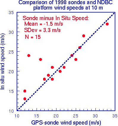
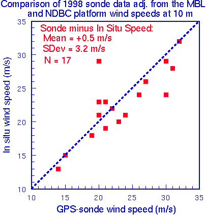
The surface and M10 wind speeds from the sondes appeared to be in fairly close agreement, especially at higher wind speeds. For example, at 0840 UTC in Georges, the sonde's surface wind speed was 33 m/s, the M10 value was 32 m/s, and the wind speed for DPIA1 was 32 m/s. The largest discrepancy in wind speeds was at 2050 UTC in Hurricane Earl, where 42040's wind was 24 m/s and the M10 wind was 26 m/s, but the surface sonde wind was only 13 m/s. The wind direction differences at the surface ranged from 0° to 18°. The surface pressures and temperatures had relatively small differences. Statistics for the differences in wind speeds indicated the mean for the sonde minus platform (10 m wind) was -1.5 m/s (standard deviation or sd = 3.3 m/s) and the scatter plot for these differences is shown in Figure 1. The mean for the M10 minus platform was +0.5 m/s (sd = 3.1 m/s), which is shown in Figure 2. The sonde minus platform surface pressures had a mean of near 0.0 kPa (sd = 0.2 KPa) and the sonde minus platform temperature had a mean of +0.1° C (sd = 0.4° C).
Based on the preliminary results from this study using real-time sonde data in relatively high winds from three hurricanes in 1998, the sondes appeared to be recording very accurate and representative wind speeds in the cases examined here. There appeared to be a slight negative bias in the sonde's reported surface wind speeds, while there was hardly any bias in the wind speeds adjusted to 10 m using the MBL winds. The pressure and temperature observations also showed good agreement between the sondes and surface platforms. Although these results are very preliminary, it appears that the sondes provide accurate measurements in the boundary layer and near surface observations which are extremely beneficial for operational and research purposes. Future work will require looking at statistics for all sondes and surface platform comparisons that are available during the 1996-1999 hurricane seasons.