 Central Equatorial Pacific Experiment (CEPEX)
- Principal Investigator:
- Paul Willis (CIMAS)
- Other Scientists:
- Chris Samsury
(The Weather Channel)
- Andy Heymsfield (NCAR)
Objective
The purpose of the
Central Equatorial Pacific Experiment (CEPEX) is to
investigate this mechanism. The overall scientific goal of
CEPEX is to establish the respective roles of cirrus radiative
effects and surface evaporation in limiting maximum surface
temperature in the equatorial Pacific. Of the so-called atmospheric
greenhouse gases, water vapor is the most effective in producing
surface-atmospheric warming. Water-vapor concentrations increase
rapidly over the tropical oceans when sea surface temperatures
(SSTs) begin to rise. This effect is greatest over the huge
"warm pools" of the Pacific Ocean. The water-vapor content of
the atmosphere above the ocean increases by about 15-20% for
each 1% of increase in SST. These increasing concentrations of
water vapor trap more and more heat, which causes the ocean's
surface temperature to rise even further, thus creating a
"super-greenhouse effect." Unchecked, this feedback mechanism
would result in runaway warming. This is not what is observed,
however; even in the "warm pool," SSTs never exceed 304°K
(31°C). This suggests that some kind of "thermostat" might
exist. Furthermore, deep intensive convection over the tropical
oceans (cloud tops reaching altitudes of 18-20 km) occurs only
when SSTs exceed about 300°K These observations raise two
central questions:
- Why do maximum SSTs in the tropical oceans remain within a
few degrees of the 300°K threshold SST for deep convection?
- What are the restoring forces that limit SST and deep
convection to observed tropical Pacific values?
It has been argued that cooling by evaporation from the ocean
surface provides such a mechanism. However, observations from
space and from the atmospheric boundary layer indicate that
this process is not sufficient. Rather, it may be the very high
and cold cirrus clouds, streaming from tropical thunderstorms,
stretching over large areas of the Pacific, and reflecting the
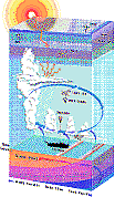
incoming solar radiation that, in fact, act as a thermostat.
Rationale
Direct in-situ measurement of radiation fluxes, cirrus
microphysics, evaporation rates, and water-vapor distributions
must be obtained over a range of SSTs, from regions where SST
is just below the convection threshold temperature to regions
where SST exceeds it. Accordingly, the CEPEX experiment domain
encompassed the transition (with respect to SST) region from
the central equatorial Pacific to the tropical south Pacific or
the tropical western Pacific "warm pool."
The primary experimental objectives of CEPEX are to:
- Measure, by direct atmospheric observations, the vertical structure of the water-vapor greenhouse effect.
- Measure the effect of cirrus on radiation fluxes over the equatorial Pacific.
- Measure the east-west gradients of SST and the evaporative and sensible heat-flux from the sea surface along the equatorial Pacific.
- Measure the east-west gradients of vertical distribution of water-vapor along the equatorial Pacific.
- Explore the microphysical factors contributing to the high albedo of widespread tropical cirrus layers.
Method
CEPEX was conducted in March 1993 with an operations base in
Fiji, immediately following the
TOGA-COARE study of the western tropical Pacific Ocean,
taking advantage of many of COARE's observing systems,
including several critical ones that remained in place during
the CEPEX field phase. Data from the TOGA-COARE field phase
provides information essential to CEPEX (i.e., understanding
the most important forcing mechanisms for maintenance of the
warm pool). CEPEX contributes to the interpretation of
TOGA-COARE results by providing coverage for an extended period
and over a larger area and by focusing on the thermodynamic
cloud forcing mechanism for the regulation of the ocean warm pool.
Observations from high-altitude aircraft above and below the
cirrus are used to estimate the albedo of cirrus and the
radiation energy converging into the cirrus, as well as the
water-vapor distribution above and below the cirrus, the
horizontal gradient of cirrus radiative heating, and the
microphysical causes for the brightness of the cirrus.
Observations from the NOAA WP-3D and
NCAR Electra aircraft, as well as a ship are used to
estimate evaporation from the sea surface and its relationship
to SST gradients and how the cirrus regulates solar energy flux
to the sea surface. In addition, upsondes launched from the
ship and islands, dropsondes launched from aircraft, surface
buoys, satellite cloud data, and island surface meteorological
and radiation sensors complete the CEPEX composite observing
system.
Accomplishments
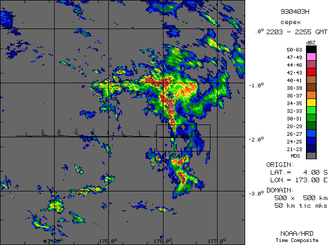
Radar data have been reduced and composites produced for the
CEPEX, a project. HRD produced of the
Lower Fuselage Radar time composites for the 13 WP-3D flights
during CEPEX.
| Example: Lower fuselage radar composite for
the flight on 3 March 1993. The map represents the horizontal
precipitation distribution over ~1h in time and 500 X 500 km in
area. |
 |
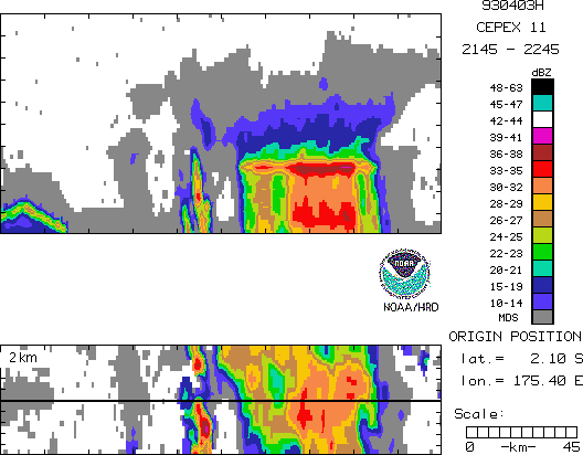
HRD also produced Tail Radar
time composites for selected flights to map the
three-dimensional precipitation structure for use in analysis
of the radiation data.
| Example: Tail radar time composite for the
flight on 3 March 1993. The map represents vertical and
horizontal cross sections through the domain is delineated by
the rectangle in the lower left of the lower fuselage
composite. The vertical cross section is along the line on the
horizontal cross section.
| 
|
| Example: Tail radar time composite for the flight
on 3 March 1993. The map represents 8 horizontal cross sections
at altitudes from 1-8 km. The domain is delineated by the
rectangle in the lower left of the lower fuselage composite.
| 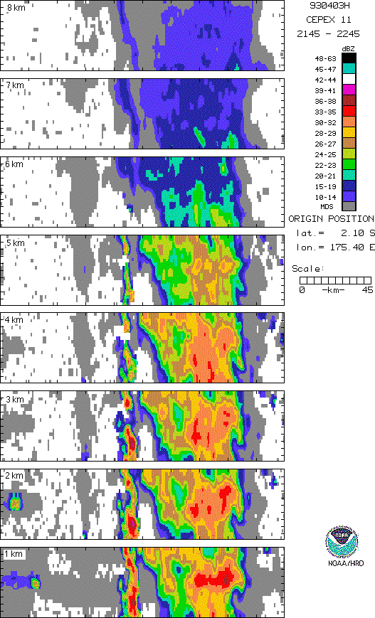
|
Future work will focus on analysis of the data from a
multi-aircraft portion of the CEPEX experiment on 2 March 1993,
a segment with a NOAA P-3 aircraft in the boundary layer taking
in situ and radar data, a Lear jet making cirrus microphysical
measurements, and the NASA ER-2 making remote sensing
measurements over the top of a mesoscale convective system.
 willis@aoml.noaa.gov
Updated May 5, 1998