WMO/CAS/WWW
FIFTH INTERNATIONAL WORKSHOP on TROPICAL CYCLONES
Topic 1.5: Numerical Model Guidance
Co-Rapporteurs: Shuyi S. Chen1 and Naomi Surgi2
1University of Miami/RSMAS, Miami, Florida, USA
2NOAA/NCEP/Enviroment Modeling Center, USA
1E-mails: schen@rsmas.miami.edu
FAX: 305-361-4696
2Email: Naomi.Surgi@noaa.gov
FAX: 301-763-8545
Working Group: S. Braun, C.-S. Liu, I. Ginis, K. Walsh, R. Morison, M. Ueno, Y. Wang.
Abstract
Tropical cyclone (TC) track forecasts have continued to improve over the last several years. However, the intensity forecasts are still lagging behind. This is clearly evident in the most recent numerical model predictions of Hurricane Lili (2002). None of the current numerical model guidance captured the rapid intensification or the rapid decay before the landfall of Hurricane Lili in the Gulf of Mexico. Both the research and operational communities are focusing on improving the model performance for TC structure and intensity changes. Here we will focus on progress made in both operational and research models over the last four years since the last IWTC-IV. Key issues related to model resolutions and physical representations are discussed. This working group addresses both the operational and research modeling perspectives for advancing TC intensity and outer wind structure forecasts.
1.5.1 Introduction
Numerical weather prediction (NWP) models have increasingly played a vital role in advancing the operational forecasting skill of tropical cyclones (TCs). Over the past three decades, the average official 72-h TC track forecast error has been reduced by over 50%, which can be largely attributed to major advances in operational NWP systems. In the last fifteen years, this skill has accelerated with the introduction of global models in the mid-1980s and with further upgrades and refinements of global modeling systems during the 1990s. Another important contribution from the research community has been the development of high-resolution regional dynamic models with advanced physics.
This advancement of dynamical modeling systems has not had the same positive impact for improving intensity forecasts, which still lag behind the statistical intensity forecast models. Although current statistical models make use of the skill of global models in forecasting important input features that influence intensity changes such as vertical shear, they only provide rudimentary information on storm size and intensity and lack a comprehensive detailed description of changes in storm structure that are crucial to provide more quantitative information to meet operational demands for TC watches and warnings.
Over the last 4-5 years, both idealized simple dynamic models and high-resolution, full physics numerical models have been used to improve our understanding of physical processes that control the structure and evolution of TCs. To resolve the TC inner core structure, which is crucial in intensity forecasting, some research models use horizontal grid resolutions of 1-2 km. At this resolution, we are not only able to simulate the inner-core dynamics, but also explicitly resolve the convective processes that have previously been represented by cumulus parameterizations at lower resolutions. Recent studies have also indicated that the quantitative precipitation forecasting (QPF) in TCs has been improved, especially for the concentrated high rainrate near the inner core. These progresses are important for development of the next generation of operational forecasting models. The plan has been made to adept the high-resolution Weather Research and Forecasting (WRF) Model for prediction. Some of the development work has been underway over the last year.
The ultimate goal of the NWP models should be consistent skillful forecasts of TC track and intensity change over all TC basins. Although statistical models will continue to be used at operational forecast centers for guidance on TC intensity forecasts, future work should be focused toward developing more advanced high-resolution NWP systems. These systems must include advanced initialization of the TC vortex, high-resolution physics, and coupling to the ocean and land surface that can address the details of the TC vortex structure and the interaction of the TC with the environment.
1.5.2 Operational Modeling Efforts
The operational TC forecast community has identified improving intensity forecasts and TC- related rainfall forecasts and associated inland flooding as high priority forecast issues. Although global and relatively higher resolution regional models have advanced track forecast skill, the above forecast challenges will require very high resolution NWP coupled systems with advanced high-resolution physics. However, continued improvements of the global model systems are required to provide a realistic TC environment that includes both the atmosphere and the ocean.
a) Model physics
The sensitivity of TC structure to model physics is now well known from the high-resolution TC studies by the research community over the past 4-5 years (see next section). Even with a coarse resolution global model, this sensitivity was documented in a study by Surgi et al. (1998) that compared upgraded physics in the NCEP global model verses more rudimentary treatment of the boundary layer and deep convection. These physics play a crucial role in maintaining the TC structure through the vertical distribution of heating and the important feedback between the boundary layer and the deep convection to support the vertical coupling in the TC vortex. It was also found that enhanced model vertical resolution is also important to provide a detailed description of the heating profile that is crucial to properly represent the vortex structure.
.
In anticipation of upgrading the Geophysical Fluid Dynamics Laboratory (GFDL) model physics for benchmarking the GFDL prior to its replacement by the next generation NOAA WRF, the GFDL model is currently being tested with various new physics for deep convection and boundary layer. Fig. 1.5.1 shows the 36-h forecast for Hurricane Isidore from the operational GFDL model with a moist convective adjustment scheme and Mellor-Yamada 2.5 boundary layer. Fig. 1.5.2 shows the 36-h forecast of the GFDL model with physics of the NCEP Global Forecast System (GFS).
Note that the GFS physics provide a much more realistic overall TC structure including the spreading out of the upper-level heating along the TC anvil. Also, the impact of the improved TC structure feeds back to improve the TC track forecast, whereas the operational model accelerates Isidore northwards in the Gulf of Mexico with landfall along the Gulf Coast states in 72 h. The upgraded GFDL model slows the forecast in the central Gulf, which is more consistent with reality. The feedback of improved TC structure in improving track is also consistent with the results of Surgi et al. (1998).
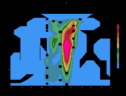
Fig. 1.5.1 Cross-section of Hurricane Isidore with the old GFDL physics (i.e., Kurihara cumulus parameterization, Mellor-Yamada 2.5 closure on PBL). The shading is the total heating, the contours are the wind speed.

Fig. 1.5.2 Cross-section of Hurricane Isidore with the upgraded GFDL physics from the NCEP global model (i.e., SAS+MRF PBL).
Work on developing an appropriate microphysics package is also progressing at NCEP and NRL (Naval Research Laboratory) in Monterey, California. The NRL has adapted a microphysics package (Rutledge and Hobbs, 1983) that includes two ice components (cloud ice and snow). This microphysics option produces less and delayed precipitation that generally results in less intense TCs. More recently, NRL has an upgraded version of the microphysics parameterization that includes grauple as the third ice component, which improves the conversion calculation with consideration of mass conservation. This version is currently being evaluated for impact on intensity forecasts.
Many uncertainties remain in developing microphysics, e.g., how to partition the liquid verse ice and how many species of ice need to be represented? Previous studies have shown that different ice species have different terminal velocities that can greatly affect the downdrafts, consequently, the TC’s intensity. Much testing needs to be carried out at different model resolutions to provide more insight into this problem.
Timeliness requirement and computing resource constraints will prevent some operational centers from running TC models at grid resolutions less than 6 km. How to represent unresolved moist convection at these scales is a very important and timely topic.
b) Air-sea and air-land coupling
The effect of tropical cyclone-ocean interactions on the intensity of observed hurricanes was investigated by Bender and Ginis (2000) by coupling the GFDL hurricane model (Kurihara et al. 1998) with a high-resolution version of the Princeton Ocean Model. Bender and Ginis (2000) tested the ocean coupling for two cases of Hurricane Opal (1995) and one case of Hurricane Gilbert (1988) in the Gulf of Mexico and two cases of Hurricanes Felix (1995) and Fran (1996) in the western North Atlantic. It was shown that the coupling produced a significant cooling of the sea surface resulted in a substantial decrease in the evaporation and boundary layer moist static energy over the cold wake. A substantial decrease in SST, when the storms were moving slowly, had a large impact on the storm intensity. In each of the seven forecasts, inclusion of the ocean coupling generally led to improvements in the prediction of storm intensity, as measured by the minimum sea-level pressure (SLP), relative to the operational (uncoupled) GFDL model.
During the 1998-2000 hurricane seasons, the coupled GFDL/University of Rhode Island hurricane-ocean model described in Bender and Ginis (2000) was run in near-real time for more than 350 cases in the Atlantic and Gulf of Mexico. Improved intensity forecasts were again achieved, with the mean absolute error in the forecast of minimum SLP reduced by about 26% compared to the operational (uncoupled) GFDL model. The largest improvements (30.5 %) were achieved for intense hurricanes (less than 980 hPa) (Ginis et al. 1999, 2000).
Fig. 1.5.3 Time series of minimum SLP for the uncoupled GFDL forecast (solid line) and the coupled GFDL/URI model (dot-dashed line) compared to observed values (circles with values every 6 h) for the forecasts of Hurricane Bonnie (from Ginis et al. 2000).
The predicted 72-h time series of the minimum SLP for Hurricanes Bonnie are shown in Fig. 1.5.3. This example represents one of the best cases and is obtained during important forecast periods. On August 23, 1998, Hurricane Bonnie was moving toward the U.S. east coast. The GFDL model track forecasts were generally fairly good as the model correctly predicted that the storm's forward speed would be reduced during that period. However, the intensity forecast indicated rapid intensification, which resulted in large intensity overprediction. This overprediction occurred because the operational model had responded to very warm water underneath the storm in the global SST analysis. In the coupled model, the slow hurricane movement generated a large SST decrease below the storm. As a result, the storm intensity forecasts were significantly improved. At initial time 1200 UTC August 23 shown in Fig. 1.5.3, the coupled model correctly predicted that the hurricane would weaken by 1200 UTC August 24.
The coupling of the GFDL model to a land surface model (LSM) is an important effort to improve TC related QPF forecasts for landfalling TCs to address the inland flooding problem. Early land surface models arbitrarily cut off evaporation at landfall and increased the surface roughness. The GFDL model currently uses a bulk representation of the land surface in which potential evaporation is reduced via a cooled land surface.
A comprehensive land surface model was collaboratively developed by NCEP, the University of Oregon, the U.S. Air Force, and the NOAA/National Weather Service Office of Hydrology. Various configurations of this model are currently under testing at NCEP to account for changes in the surface fluxes as storms make landfall over various underlying surfaces. The land model includes a multi-layer effect of the direct effect/interaction of vegetation, plant interaction with evaporation, prediction of soil moisture and temperature, and canopy water content. These processes are important for storms making landfall over regions that include standing water. Fig. 1.5.4 is a schematic of the land physical processes affecting TC structural changes upon landfall that are not captured by traditional boundary layer treatments. Figs. 1.5.5a and b from Tuleya et al. (????) show substantial changes from the surface fluxes, e.g., decrease in the evaporative and sensible heat fluxes in the underlying surface at landfall. In that study, sensitivity on the 48-h intensity forecast for the landfall of Hurricane Helene was shown by comparing the TC translating over a nearly dry surface verse a saturated surface.
Fig. 1.5.4 Schematic of physical processes for hurricanes at landfall.
Fig. 1.5.5 GFDL model-simulated surface latent (a) and sensible (b) heat fluxes.
c) Model initialization
One of the biggest scientific challenges for the next-generation, high-resolution hurricane prediction systems is addressing the hurricane vortex initialization problem. In anticipation of running the next-generation high resolution coupled air/sea/land model system that will replace the GFDL model, e.g. the community-based Weather and Research Forecasting model for hurricanes (HWRF), NCEP is developing a local mesoscale data assimilation capability for initializing the hurricane core circulation. This capability is being developed to make use of real time radial velocities from the NOAA Gulfstream-IV doppler winds to describe the 3-D wind structure of the hurricane core circulation from the outflow layer to the surface. This assimilation system is being developed in concert with the NCEP’s current 3-DVar to make use of future advanced mesoscale variational data assimilation techniques being developed at NCEP. We believe this capability is critical to address the intensity problem by resolving the outflow layer of the hurricane core plus having detailed vertical resolution to the surface to properly simulate the boundary layer fluxes and resolve the vortex asymmetries.
d) Environmental effects
An accurate simulation of the large-scale flow is critical to capture the interaction of the TC with the environment to improve TC structure and intensity change forecasts. In this regard, global model improvements have provided a much improved description of the tropical environment with the advancement of the global modeling systems over the past 4-5 years. These improvements have resulted from including more observations in the environment, advanced data assimilation techniques, and continuing numerical model development. The data assimilation upgrades over the past several years have contributed to better defining the TC environment via the direct assimilation of satellite radiance data, e.g. microwave data, and a physical initialization that makes use of the assimilation of the SSM/I and TRMM precipitation data. NCEP has also begun assimilating the QuikScat data, which to date has showed some improvement near the surface in the tropics. However, optimal use of the scatterometer data will require substantial development of data quality control and better algorithms for the boundary layer schemes. Some global models have also included the use of prognostic cloud water/ice with related radiative effects. All of these advancements have contributed to provide a better description of the large-scale tropical diabatic heat sources and thus have resulted in an improved tropical circulation.
e) Model configuration
A recent improvement to the Coupled Ocean Atmosphere Prediction System (COAMPSTM) for the high-resolution TC forecast is to apply the movable inner mesh capability to follow selected tropical cyclones. For an operational forecast, the application requires a method of dynamically tracking TCs in the model forecast. The TC tracking method used in the GFDL hurricane model is adopted to follow the storm center on the COAMPSTM inner meshes every few time steps. If a TC moves away from the mesh center more than one grid distance of its mother mesh, the mesh is moved to keep the TC always near the center of the inner mesh so that its circulation can be better resolved by the high-resolution mesh during the entire forecast period. Fig. 1.5.6 shows an example of such application in which the detailed interaction between the TC Bilis and the Taiwan terrain is better resolved by the 9-km inner mesh following the cyclone.
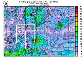
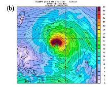
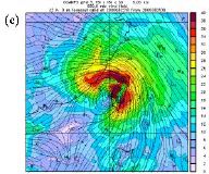
Fig. 1.5.6 Movable inner mesh application for tropical cyclone forecast in COAMPSTM: (a) 850 mb wind analysis of the 27-km resolution mesh, (b) the 850 mb wind analysis of 9-km inner mesh, and (c) 42 h forecast of the 850 mb wind of the moving 9-km inner mesh as indicated by the boxes in (a).
1.5.3 Research Modeling Efforts
A suite of research models, including idealized simple dynamic models and high-resolution, full physics numerical models, has been used to improve our understanding of the physical processes that control the structure and evolution of TCs. Here we will focus on progresses made in the full physics numerical models over the last four years since the last IWTC-IV. These progresses are helping us to pave the road for development of the next generation of operational forecasting models.
a) High-resolution atmospheric modeling
To resolve the TC inner-core structure, which is crucial for intensity forecasting, the model horizontal grid resolution needs to be at 1-2 km. At this resolution we are not only able to simulate the inner core dynamics, but also explicitly resolve the convective processes that have been limited by cumulus parameterizations at lower resolutions in the past. Recent studies have also indicated that the quantitative precipitation forecasting (QPF) in the tropical cyclones has been improved, especially at the concentrated high rainrate near the inner core (Fig. 1.5.7).
Recently a series of high-resolution model simulations of tropical cyclones has been conducted using fully nonlinear, nonhydrostatic, primitive equation mesoscale models, such as the PSU/NCAR MM5. These simulations have demonstrated the ability of the high-resolution models to re-produce the fine structures in the inner core and outer rainbands region of tropical cyclones (e.g., Liu et al., 1997; 1999; Karyampudi et al., 1998; Braun and Tao 2000, Braun 2002; Bao et al., 2000, Rogers et al., 2002, Chen et al., 2002, Tenerelli and Chen 2002, Zhang et al. 2002). Tenerelli and Chen (2000) developed a vortex-following nested-grid using the nonhydrostatic MM5 that allows long integration (5-7 days) with very high grid resolution (~1-2 km) in the inner core region of hurricanes. They use four-level nests with 45, 15, 5, and 1.67 km grid spacing, respectively. The three inner domains move automatically with the storm. The model has been used successfully to simulate Hurricane Bonnie 1998 (Rogers et al. 2002), Hurricane Georges 1998 (Orndorff et al. 2002), and Hurricane Floyd (Chen et al. 2002, Tenerelli and Chen 2001, 2002). Fig. 1.5.7 shows an example of model simulated precipitation fields at different grid resolutions. In comparison with the TRMM precipitation radar (PR) observed rainfall, the model captures the intense rainfall in the inner core very well with 1.67 km resolution, whereas the lower resolutions unable to resolve the inner core and rainband structures. For the first time a high-resolution model is able to capture the development of the concentric eyewalls and a complete eyewall replacement cycle that was observed in Hurricane Floyd. A 6-day long animation of MM5 simulation of Floyd precipitation field can be found at
http://orca.rsmas.miami.edu/floyd. Tenerelli and Chen (2002) show that the secondary rain maximum and associated a ring of potential vorticity cores lead the development of the secondary wind maximum. Braun (2002) has also conducted a very high-resolution (1.3 km) MM5 simulation of Hurricane Bob (1991) and showed clearly that the model captures the detailed dynamic and thermodynamic structure in the inner core region. These results demonstrate the capability of the high-resolution model in simulating tropical cyclone structure and intensity changes.
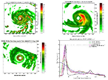
Fig. 1.5.7 Model-simulated rainfall in Hurricane Floyd with (a) 1.67 km grid spacing, (b) 15 km grid spacing, (c) observed rainfall from the radar onboard the TRMM satellite, and (d) comparison of observed (black) and model-simulated azimuthal-averaged rainfall with four different grid resolutions, 45, 15, 5, and 1.67 km, respectively.
b) Environmental effects on tropical cyclones
TCs interact with the large-scale atmospheric environment. Interactions with vertical wind shear are an important part of current statistically-based intensity forecast models and have been the subject of considerable research (e.g., DeMaria 1996; Galina and Velden 2002). Frank and Ritchie (2000) and Rogers et al. (2002) show the impacts of vertical shear on both inner-core structure and rainfall patterns of TCs are significant. Current operational models give reasonably good predictions of storm environmental vertical wind shear. In addition, real-time products are now available that give maps of vertical wind shear over many ocean basins using satellite observations such as scatterometer and cloud-drift winds (e.g.,
http://cimss.ssec.wisc.edu/tropic/tropic.html). The impact of these products on experimental forecasts using a dynamical tropical cyclone model has been assessed and found to be useful (Soden et al. 2001). Clearly, operational assimilation of such products in a dynamical TC forecast model will occur in the future.
A more challenging problem is the simulation of the interaction of TCs with tropospheric troughs. This interaction is currently not well simulated, despite recent progress in understanding this issue (e.g., Davis and Bosart 2001, 2002). Higher resolution and better representation of physics in the inner-core region are needed to give improvements, preferably using a moving, nested grid model. This issue is related to the question of the horizontal resolution needed for such a model (probably around 1-2 km ideally).
c) Moist convective processes
One of the most difficult tasks in the model simulation of tropical cyclones is representation of moist convective process. Cumulus parameterizations become obsolete when the model grid resolution increases to less than 10 km, where many assumptions that are made in the parameterizations break down. It has been identified by various studies lately that there is a “no-man’s land” in the treatment of moist convective process between 5-10 km. The high-resolution models running at grid resolution of 1-4 km use the explicit microphysics. A number of uncertainties remain in the existing microphysics formulations, partly because of lack of observations to calibrate the schemes. However, the NASA-sponsored CAMEX-4 field program during the fall of 2001 has provided a valuable dataset for both model validation and development. A number of modeling and observational studies are underway to understand the physical processes controlling the microphysical properties including the hydrometeor distributions in TCs and to evaluate/validate the high-resolution model simulations. Some preliminary results indicate that microphysical parameterizations are sensitive to whether or not the convective up- and down-drafts are correctly represented in the model, which is a very much a grid-resolution dependent problem.
d) Atmospheric boundary layer
Braun and Tao (2000) used the MM5 mesoscale model to simulate Hurricane Bob (1991) using nested grids to archive high resolution (4 km). Tests were conducted to determine the sensitivity of the simulations to various planetary boundary layer (PBL) parameterizations, including the bulk-aerodynamic, Blackadar, Medium-Range Forecast (MRF) model, and Burk-Thompson boundary-layer schemes. Significant sensitivity was documented, with minimum central pressures varying up to 16 mb and maximum winds by 15 m s-1. The Burk-Thompson and bulk-aerodynamic boundary-layer schemes produced the strongest storms, while the MRF scheme produced the weakest storm. Simulated horizontal precipitation structures varied substantially between the different PBL schemes, which suggest that accurate forecasts of precipitation in hurricanes can be just as sensitive to the formulation of the PBL as they are to the cloud microphysical parameterizations.
Each PBL scheme is different in its formulation of the vertical mixing within the PBL and the surface fluxes, except that of the MRF and Blackadar schemes share essentially the same surface flux parameterization. Detailed analyses of the PBL schemes by Braun and Tao document the key differences in the surface fluxes and how they impact storm intensity. To isolate the effects of vertical mixing and surfaces fluxes, simulations were conducted in which each of the surface flux schemes was used in conjunction with the same vertical mixing scheme, and vice versa. These experiments indicated that the simulated intensity is largely determined by the surface fluxes rather than by the vertical mixing, with the exception of the MRF PBL case in which excessively deep vertical mixing acted to dry the lower PBL and to reduce hurricane intensity. Simulations that varied only the surface fluxes suggested that the intensity of the simulated hurricane increases with increasing values of the ratio of the exchange coefficients for enthalpy and momentum, Ck/CD. However, even for identical values of Ck/CD, the simulated intensity varies depending on the wind speed dependence of the surface roughness parameter z0.
e) Air-sea interface
Establishing the behavior of air-sea fluxes and surface-exchange coefficients in high wind conditions associated with TCs is a long-standing problem. The extreme high winds, intense rainfall, large ocean waves, and copious sea spray push the surface-exchange parameters for temperature, water vapor, and momentum into untested new regimes.
There are presently few observations of transfer coefficients at high wind speeds. It has recently been realized that the production of spray in high wind speed regions can have an effect on the transfer of energy from the ocean surface to the cyclone. Recently proposed parameterizations of this effect give quite different impacts on the intensity change of tropical cyclones (Fairall et al. 1994, Andreas and Emanuel 1999, Bao et al. 2000, Wang et al. 2001, Chen et al. 2002). Nor is it clear what is the correct formulation of stability transfer coefficients for heat and momentum at high wind speeds. Inclusion of ocean wave processes in tropical cyclone dynamical forecast models is also important for this reason. New observations are needed to resolve these issues. The ONR-supported field program CBLAST (Coupled Boundary Layer Air-Sea Transfer) is on-going from 2002-2004. It will provide a unique data set for understanding the physical processes and developing new parameterizations for the air-sea fluxes.
In a recent study, Andreas and Emanuel (2001) suggest that sea spray can significantly enhance enthalpy transfer. Bao et al. (2000) have shown that the MM5 simulation of Hurricane Opal (1996) is sensitive to sea spray. However, their results also demonstrate the complex behavior as the effects of the sea spray on sensible and latent heat fluxes are acting in opposite senses as the amount of the spray increases in the model. Using the coupled MM5-WAVEWATCH III modeling system, Chen et al. (2002) show that simulation of Hurricane Floyd (1999) intensity varies by 10-20 mb is with various wind-wave coupling parameterizations. The sensitivity increases at high-resolutions (~1.67 km).
Several studies in the past few years have emphasized the importance of air-sea interaction in TC evolution (Shay et al. 2000, Bosart et al. 2000, Bender and Ginis 2000). Many current tropical cyclone dynamical forecast models continue to use specified, fixed SST as the lower boundary condition. Recent work has suggested that a more appropriate lower boundary condition is ocean heat content, or more specifically TC heat potential (e.g., White et al. 2002). As a first step, testing of operational dynamical tropical cyclone forecast models with hurricane heat potential rather than SST as a lower boundary condition may be considered. Currently, experimental hurricane heat potential products are available in near real time for most tropical cyclone formation basins (http://www7320.nrlssc.navy.mil/hhc/).
Progress has also been made on more sophisticated representations of the ocean such as coupled ocean-atmosphere models for TCs (Bender and Ginis 2000, Bao et al. 2000, Shen and Ginis 2001, Chen et al. 2002). Ultimately, dynamical TC models will work towards this more complete representation of ocean-atmosphere interaction.
1.5.4 Summary
A significant progress has been made in the numerical model guidance for TC track forecasting over the last 4-5 years, largely because of a number of improvements made in model physics and data assimilations in the global models. However, the progress in TC intensity forecasting has been lagging behind. It may be attributed by the inability to accurately resolve the TC inner-core structure and inaccurate representation of physical processes in the current NWP models. Recent studies have demonstrated that high-resolution, full physics models have the capability of resolving the TC inner-core structure and moist convective process explicitly at 1-2 km grid resolutions, which can improve the prediction of TC intensity changes and TC QPF. However, because of the computer resource constraints, whether the 1-2 km grid resolution models can be run operationally in the near future remain to be seen. Other advancements made in physical representations for high-resolution models including the coupling of the atmosphere-ocean and atmosphere-land have also shown the potential for improving TC prediction.
Bibliography
Andreas, E.L. and K. A. Emanuel, 1999: Effects of sea spray on tropical cyclone intensity. Proc. of the 23rd Conference on Hurricanes and Tropical Meteorology, Dallas, 10-15 January, 1999, Amer. Meteorol. Soc., pp. 22-25.
Bao, J.-W., J. M. Wilczak, J.-K. Choi, and L. H. Kantha, 2000: Numerical simulations of air-sea interaction under high-wind conditions using a coupled model: A study of hurricane development. Mon. Wea. Rev., 128, 2190-2210.
Bender, M. A. & Ginis, I. Real-case simulation of hurricane-ocean interaction using a high-resolution coupled model: effects on hurricane intensity. Mon. Wea. Rev., 128, pp. 917-946, 2000.
Braun, S. A., 2002: A Cloud-resolving simulation of Hurricane Bob (1991): Storm structure and eyewall buoyancy. Mon. Wea. Rev., 130, 1573-1592.
Braun, S. A., and W.-K. Tao, 2000: Sensitivity of high-resolution simulation of Hurricane Bob (1991) to planetary boundary layer parameterizations. Mon. Wea. Rev., 128, 3941-3961.
Bosart, L.F., Velden, C.S., Bracken, W.E., Molinari, J. & Black, P.G., Environmental influences on the rapid intensification of Hurricane Opal (1995) over the Gulf of Mexico. Mon. Wea. Rev., 128, pp. 322-352, 2000.
Chen, S. S., R. C. Foster, J. Tenerelli, T. W. Liu, 2002: Improving hurricane prediction using the QuikSCAT surface winds in model initialization. Geophys. Res. Lett., submitted.
Chen, S. S., Wei Zhao, J. E. Tenerelli, M. A. Donelan, 2002: Atmosphere-Wave-Ocean Coupling in Tropical Cyclones. Preprints, 25th Conference on Hurricanes and Tropical Meteorology, 28 April – 3 May 2002, San Diego, California, AMS, 599-600.
Davis C, Bosart LF, 2002: Numerical simulations of the genesis of Hurricane Diana (1984). Part II: Sensitivity of track and intensity prediction. Mon. Wea. Rev., 130 (5): 1100-1124.
Davis C, Bosart LF, 2001: Numerical simulations of the genesis of Hurricane Diana (1984). Part II: Control simulatoin. Mon. Wea. Rev., 129 (8): 1859-1881.
Fairall, C.W., Kepert, J.D. & Holland, G.J. The effect of sea spray on surface energy transports over the ocean. Global Atmos. Ocean Syst., 2, pp. 121-142, 1994.
Frank, W. M., and E. Ritchie, 2001: Effects of vertical wind shear on the intensity and structure of numerically simulated hurricanes. Mon. Wea. Rev., 129, 2249-2269.
Gallina GM, Velden CS (2002) Environmental wind shear and tropical cyclone intensity change using enhanced satellite derived wind information. Proceedings of the 25th Conference on Hurricanes and Tropical Meteorology, San Diego, 29th April-3rd May, 2002, American Meteorological Society, pp 172-173.
Liu, Y., D.-L. Zhang, and M. K. Yau, 1997: A multiscale numerical study of Hurricane Andrew (1992). Part I: Explicit simulation and verification. Mon. Wea. Rev., 125, 3073-3093.
Liu, Y., D.-L. Zhang, and M. K. Yau, 1999: A multiscale numerical study of Hurricane Andrew (1992). Part II: Kinematics and inner-core structures. Mon. Wea. Rev., 127, 2597-2616.
Orndorff, C. M., S. S. Chen, J. E. Tenerelli, 2002: Precipitation and landmass interaction during Hurricane Georges (1998) landfall at Puerto Rico. Preprints, 25th Conference on Hurricanes and Tropical Meteorology, 28 April – 3 May 2002, San Diego, California, AMS, 297-298.
Rogers, R., S. S. Chen, J. E. Tenerelli, and H. E. Willoughby, 2002: A numerical study of the impact of vertical shear on the distribution of rainfall in Hurricane Bonnie (1998), Mon. Wea. Rev., conditionally accepted.
Shay, L.K., Goni, G.J. & Black, P.G. Effects of a warm oceanic feature on Hurricane Opal. Mon. Wea. Rev., 128, pp. 1366-1383, 2000.
Shen, W. and I. Ginis, 2001: The impact of ocean coupling on hurricanes during landfall. Geophys. Res. Letters 28, 2839-2842.
Soden BJ, Velden CS, Tuleya RE. 2001, The impact of satellite winds on experimental GFDL hurricane model forecasts. MON WEATHER REV 129 (4): 835-852.
Surgi, N, Pan, HL & Lord, S.J.: Improvement of the NCEP Global Model over the Tropics: An evaluation of model performance during the 1995 hurricane season. Mon. Wea. Rev., 126, 1287-1305.
Tenerelli, J. E., S. S. Chen, 2001: High-resolution simulation of Hurricane Floyd (1999) using MM5 with a vortex-following mesh refinement. Preprints, 18th Conference on Weather Analysis and Forecasting/14th Conference on Numerical Weather Prediction, 30 July-2 August 2001, Ft. Lauderdale, Florida, AMS, J54-J56.
Tenerelli, J. E., and S. S. Chen, 2002: Intensity change and eyewall replacement in Hurricane Floyd (1999). Preprints, 25th Conference on Hurricanes and Tropical Meteorology, 28 April – 3 May 2002, San Diego, California, AMS, 168-169.
Wang, Y., Kepert, J.D., & Holland, G.J. The effect of sea spray evaporation on tropical cyclone boundary-layer structure and intensity. Mon. Wea. Rev., 129, 2481-2500, 2001.
White, S.R., M.M. Mainelli, S. D. Jacob and L.K. Shay, 2002. Hurricane heat potential estimates from monthly versus seasonal temperature and salinity data. Proceedings of the 25th Conference on Hurricanes and Tropical Meteorology, San Diego, April 29-May 3, 2002, American Meteorological Society, 128-129.
Session 1.5.
<
P>