WMO/CAS/WWW
FIFTH INTERNATIONAL WORKSHOP ON TROPICAL CYCLONES
TOPIC 2.1 Observing and forecasting rainfall
Rapporteur: Chen Lianshou
Chinese Academy of Meteorological Sciences
46 Zhongguancun South Street
Beijing, 100081, China
E-mail: cams@public.bta.net.cn
Fax: 86-10-62175931
Working Group
Abstract
Studies (Chen and Luo, 1995) showed that the typhoon structure may be greatly changed during its landfalling. The topographic forcing plays an important role for the structure change when tropical cyclone approaches the land. These structure changes often give rise to tropical cyclone intensity changes and sudden track turns. On the other hand, the enhancement of rainfall from a landfalling typhoon has been closely related to its structure and intensity change as well. The genesis of heavy rain producers such as a squall line in front of typhoon and thunderstorm tornadoes in right front quadrant (Shen Shuqin, 1990) of a landing typhoon were related to the mountain range convergence forcing.
Apart from the topographic effect, structure changes in a tropical cyclone may be influenced by the interaction with a peripheral meso scale vortices (MSV) or a tropical cloud cluster. Typhoon rainfall will be enhanced when the MSV merges into the core region of the tropical cyclone. The environmental systems such as an inverted V trough, easterly wave, shear line etc. as well as topographic forcing will contribute to an asymmetric distribution of heavy rainfall around the time of tropical cyclone landfall.
The interaction between a landfall typhoon and a mid-latitude system such as a westerly trough may play an important role in the typhoon-caused rainfall intensity and distribution. Very heavy rain areas often appear in front of a westerly trough with a typhoon well to the south. Very heavy rain would usually occur in the time period of its transition, proper cold air will increase the stratified instabilities to trigger vertical motion and very heavy typhoon rain.
Mesoscale numerical models have been employed on an operational basis to predict the typhoon-caused heavy rainfall. A little progress has been made to reduce the forecasting error. Radar observations and remote sensing data from various satellites still offer a great help for rainfall monitoring and estimation as well as the prediction of short range typhoon-caused rainfall. Automatic weather stations (AWS) and rain gauges spreaded over a wide area with intensive observations were useful and effective devices for rainfall data acquisition.
2.1.1 Introduction
Typhoon-caused rainfall is a major area for landfalling tropical cyclones. Calamities were often brought about by typhoon rainstorm. The extreme heavy rainfall of 1062mm/24h in Henan Province was produced by landing Typhoon Nina (1975). This is the highest rainfall record in mainland China. Two huge reservoirs and more than ten small reservoirs were collapsed at almost the same time. Tens of thousands people were killed. More strong rainfall of 1248mm/24h at Baxin of Taiwan province and 1672mm/24h at Xinliao, Taiwan province were produced by Typhoon Gloria (6312) and Carla (6718) respectively. Calamities arose from those typhoon-caused unbelievable amount of rainfall.
Such heavy rainstorm were produced by strong mesoscale convective system, while mesoscale and microscale systems were often actively produced in the time period of landfall with the topographic convergence forcing. This phenomenon draws a great attention from the research scientists and operational forecasters. Research results showed that the intensity and distribution of typhoon-caused rainfall are closely related to the structure/intensity of typhoons as well as the topographic forcing and the interaction with the peripheral mesoscale vortices (MSV) and environmental circulation systems. The interaction between landing typhoons and mid-latitude systems also plays an important role for the rainfall.
Forecasting techniques and observing devices have been surveyed for the past few years as well.
2.1.2 Interaction with the MSV
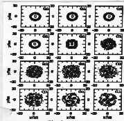
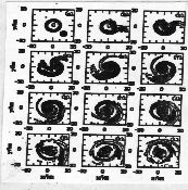
Tropical cyclone rainfall depends partially upon the cyclone intensity. The interaction between landing cyclone and meso-scale vortices, in certain condition, will increase the cyclone intensity and corresponding rainfall (Luo and Chen 2002). Two sets of numerical simulations with barotropic quasi-geostropic equation were implemented. Fig. 1 is without the MSV and only has the typhoon and Fig. 2 has both the typhoon and the MSV, which is in the southeast quadrant. The simulation vorticity (_) field is output every ten minutes.
|
|
|
| Fig. 1 Result of set one, vorticity field changes without MSV | Fig. 2 Result of set two, vorticity field changes with MSV |
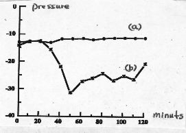
The result of set one shows that the vorticity field basically keeps the same pattern from 50 minutes to 110 minutes (Fig. 1) and the central pressure didn’t change much. The result of set two shows that the vorticity field strengthened obviously after the MSV merged into the core region of typhoon (Fig. 2) and the central pressure decreased continuously (Fig. 3). These values of central pressure have been calculated from the vorticity (_) with the nonlinear balance equation. In comparison with (a) and (b) in Fig. 3 exhibit that the interaction between typhoon and MSV plays an important role for the great decrease of central pressure and intensified the typhoon. It is inferred that the MSV transfer the vorticity to core region and to strengthen the typhoon intensity as well as to enhance the corresponding typhoon-caused rainfall.
Pressure (hpa)
minutes
|
Fig. 3 Central pressure variations with time in two numerical simulations a: without MSV in experiment 1 b: with MSV in experiment 2 |
Landfalling tropical cyclones usually produce an asymmetric distribution of rainfall. Case study (L. Chen, 1979) shows that the asymmetric distribution of rainfall may be related to the two following causes.
When a typhoon approaches a continent, a part of typhoon circulation toward the coastal area could form a convergence zone between the coastal topography and the flow toward the coast line. Since the flow field in the opposite semicircle of the typhoon is toward the ocean, no coastal convergence can be formed in this case. The coastal convergence zone bring about an asymmetric rain distribution with huge rainfall on the convergence side and less rainfall in the opposite side.
The similar process of an asymmetric rainfall distribution would happen at an inland mountain range in instead of the coast. The huge rain area and strong rainfall will go along with the topographic convergence zone.
Adjacent circulation systems can also produce the asymmetric typhoon-caused rainfall distribution. An inverted V trough often stretches northward from the typhoon center. The formation of the inverted typhoon trough is related to topographic effect and easterly wave propagation. The rainfall will then be extended northward behind the inverted trough. An asymmetric distribution could be formed with a huge rainfall area along with the inverted trough in the north semi-circle and a smaller rainfall area in the south semi-circle of the typhoon.
The interaction between typhoon and adjacent systems such as shear line, easterly wave and cloud cluster can also produce an asymmetric distribution in a landing typhoon.
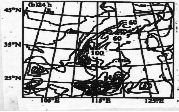
2.1.4 Interaction with mid-latitude trough
|
Fig. 4. Interaction between landing typhoon and mid-latitude trough
|
The intensity of the rainfall in front of the trough depends upon the trough vorticity and the intensity/strength/size of typhoon. A numerical experiment by H. Zhu et al. (2000) studied the rainfall in the remote area from the landing Typhoon Tim (9406). The PSU/NCAR mesoscale model MM5 was employed with an initial time of 12 GMT 11 July and with a 24h integration. The rainfall distribution in the control test (Fig. 5) was near coincident with the observations. Sensitivity tests showed rainfall associated with the mid-latitude trough was obviously weakened (Fig. 6) if the intensity of the landing typhoon was decreased. The results indicated that the rainfall intensity in front of the mid-latitude trough was closely related to the intensity of landing typhoon.
|
|
|
| Fig. 5 Control test of rainfall associated with Typhoon Tim and a mid latitude trough | Fig. 6 Sensitivity test of rainfall with the intensity of Tim decreased |
2.1.5 Forecast techniques
Techniques of rainfall forecasting associated with landfalling tropical cyclones can be divided into four categories dynamics, statistics, combined dynamics with statistics and empirical method. Many tropical cyclone forecasting centers employ a mesoscale model like MM5 or a limited area model for typhoon-caused rainfall forecast.
Y. Duan (2002) carried out a case study of the torrential rainfall caused by a tropical depression that was landing on the coast of Fujian province on 3 Aug. 2001 and the storm struck Shanghai on 5 Aug. A heavy rainfall of 275.2mm/24hours occurred from 00GMT 5 Aug. to 00GMT 6 Aug. Severe disaster arose from the rainstorm associated with the landing tropical depression. The PSU/NCAR nonhydrostatic MM5 model (Grell et al. 1994) was employed with primitive equations, Lambert projection and sigma coordinates.
|
|
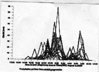
|
| Fig. 7 Rainfall intensity observed by several Auto rain gauges (mm) |
Fig. 8 Simulated rainfall intensity
|
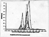
Compare Fig.8 with Fig.7. The simulated rainfall in Fig. 8 agreed with the observations except that the simulated peak rainfall was 120mm which was 30mm higher than the observation. The results from the limited-area model forecast were the same. The simulated maximum rainfall amount was 75mm more than the observation (Fig.9).
|
|
|
|
Fig. 9 Total rainfall from 08:00 Aug 5 to 08:00 Aug. 6 caused by a tropical depression
|
|
|
(a) Observation
|
(b) Numerical Simulation
|
Various meteorological satellites are powerful devices to monitor the behavior of the tropical cyclone. The black-body temperature (TBB) data from satellites can offer some information concerning the rainfall intensity and distribution as well as the structure and intensity change of the tropical cyclones. The TRMM is the first satellite borne Precipitation Radar (PR) that combined visible and infrared scanner (VIRS) and TRMM Microwave Imager (TMI) observations to observe the typhoon structure and its heavy rainfall. Chen Minghu et al (2002) has analyzed Typhoon SAM (1999) with TRMM data. Sam formed on 19 Aug. 1999 over the sea east to Philippines, and then moved northwestward across Luzon island and the South China Sea, and made landfall around the estuary of Pearl River. Total rainfall from Sam was 616.5mm/72hours, which exceeded the maximum rain record since 1926.
The digital reflectivity(z) can be derived from the TRMM products.Compared with the reflectivity from the Hong Kong radar (Table 1), it can be seen that the two set of data are matched quite well.
Table 1 Correlative coefficient of reflectivity from
TRMM/PR and HK radar (Typhoon “Sam”)
|
Range from Radar site
|
No. of data Pairs
|
Correlation Coefficient | |
| Averaging method | Matching method | ||
|
All range
|
2124
|
0.69
|
0.90
|
|
_ 100km
|
899
|
0.75
|
0.94
|
|
≥ 100km
|
1225
|
0.66
|
0.87
|
The reflectivity(z) can be converted into precipitation (R) with the relation Z=200R1.6. The scattergram of precipitation between the PR on the TRMM and the radar in Hong Kong (Fig. 10) shows that a relatively good correlation exists in for typhoon rainfall observation.
|
|
| Fig. 10 The scattergram between the PR and Hong Kong radar-derived reflectivity for the case of 23 August 1999. |
Doppler radar deployed along the coast will provide the detail structure of wind field and rainfall intensity/distribution associated with offshore or landfalling typhoons. The digital echoes from WSR-88D radar at very east tip of Shanghai were helpful to estimate the Typhoon Chebi’s rainfall.
|
|
|
| Fig. 11 Hourly heavy rain 15:00-16:00BST 23 June 2001 caused by a typhoon Chebi’s inverted trough combined with a front. (a) Observed by automatic weather stations (AWS); (b)Corresponding digital radar echo from WSR-88D radar |
Very heavy rain caused by the inverted trough in the typhoon circulation in combined with a front over the estuary of the Yangtze river on 23 June 2001. Fig. 11 shows hourly precipitation observed by AWS (a) and radar (b). Both data on rainfall intensity and distribution were quite agreeable (Shao 2002)
1. The digital radar echoes are valuable for typhoon rainfall nowcasting as well.
Heavy Rainfall Intensity and Distribution (HRID) is a major problem for tropical cyclone landfall. Observations from satellite remote sensing and radar echoes play an important role for very short range forecast of HRID. The Short-range Warning for Intense Rainstorms in Localized Systems (SWIRLS) has been employed in Hong Kong Observatory for rainstorm nowcasting. The method they used as follow:
|
|
| Fig. 12 TREC analysis and radar echoes of Typhoon Utor to the northwest of Hong Kong (at the center of the figure) at 0918 UTC on 6 July 2001 |
Heavy rainfall brought about by a landfalling typhoon may be strongly influenced by topographic forcing, typhoon structure/intensity change, mesoscale vortices, environmental circulation system interaction, moisture supply, etc.
Major forecasting techniques for typhoon rainfall would be the various mesoscale numerical models or limited-area models with fine mesh and 3D or 4-D data assimilation. Other techniques such as statistical schemes or dynamical techniques combined with statistical schemes, and empirical methods also can offer certain guidances for real-time rainfall forecasts.
Digital remote sensing data from satellite, Doppler radar, and the AWS data still play an important role for tropical cyclone rainfall monitoring and very short-range rainfall forecasting.
Bibliography
Chen Lianshou, Luo Zhexian, 1995: Some Relations Between Asymmetric Structure and Motion of Typhoon. ACTA METEOROLOGICAL SINIC, Vol. 9, No. 4, pp412-419.
Shen Shuqin, 1990: Tornadoes In Front Quadrant Of Typhoon, Proceedings of Tropical Cyclone Workshop, Meteorological Press, pp87-94.
Chen Lianshou, Luo Zhexian, 1998: Numerical Study on Functions Affecting Tropical Cyclone Structure and Motion. ACTA METEOROLOGICAL SINIC, Vol. 12, No. 4, pp504-512.
Chen Lianshou, Ding Yihui, 1979: The Introduction to Typhoons over Northwest Pacific. Science Press, Beijing. Pp1-491.
Zhu Hongyan, et al, 2000: A Numerical Study of the Interactions between Typhoon and Mid-latitude Circulation and Its Rainfall Characteristics. Chinese Journal of Atmospheric Sciences, Vol. 24, No.5, pp669-675.
Luo Zhexian, Chen Lianshou, 2002: The Mechanism Study on the Sustention and Intensification of Landfalling Typhoons (wait listed).
Dudhia, J. , 1989: Numerical Study of Convection Observed during Winter Monsoon Experiment Using a Mesoscale Two-dimensional Model. J. Atmos. Sci., 46, 3077-3107.
Grell, G. A., J. Dudhia and D. R. Stauffer, 1994: A description of the fifth-generation Penn State/NCAR Mesoscale Model (MM5). NCAR Technical Note, NCAR/TN-398+STR, 117pp.
Grell, G. A., 1993: Prognostic Evaluation of Assumption Used by Cumulus Parameterizations. Mon. Wea. Rev., 121, 764-787.
Cheng, M. et al, 2001: Study of 1998 Heavy Rainfall over the Yangtze River Basin Using TRMM Data, Adv. Atm. Sci., Vol, 18 387-396.
Cheng, M, H. He and B. Xiu, 2002: Retrieval of 3-D Structures of Cloud-precipitation System Using TRMM Data, Submitted to Chinese Sciences Bulletin.
Kummerow C., Barnes W., Kozu T., Shiue J. and Simpson J. 1998: The tropical Rainfall Measuring Mission (TRMM) Package. J. Atmos. And Ocean Tech., 15, 809-817.
Mao, D., M. Cheng, Z. Cui, and X. Zhou, 2002: Estimation of Instantaneous Precipitation over Chinese Sea Using TRMM TMI Data, Submitted to Adv. Atm. Sci.
1 Shao Ling 2002, Technical report, Shanhai Central Weather Office
Session 2.1