This document is divided into 3 sections:
The Hurricane Landfall Program has been modified for 1994 to improve the real-time and post-storm analyses of tropical cyclone wind fields near landfall. The program will continue to be a combined land-sea-air operation of opportunity geared to obtain ob servations in storms forecast to make landfall on the coast of the continental United States (Atlantic and Gulf of Mexico) within 24 to 36 h. When landfall is imminent, observations are made with the NOAA/AOC WP-3D aircraft. Land based chase teams observe and record the storm's approach and landfall from National Weather Service (NWS) radars. NWS and marine observation sites are alerted before landfall and after the storm's passage damage surveys will be conducted.
An accurate description of the tropical cyclone surface wind field near landfall in real-time is important for warning, preparedness, and recovery efforts. HRD is developing a real-time surface wind analysis system to aid the National Hurricane Center ( NHC) in the preparation of warnings and advisories in tropical cyclones. The surface wind analyses could reduce uncertainties in the size of hurricane warning areas and could be used for post-storm damage assessment by emergency management officials. Sur face marine wind observations are only available in real-time from National Data Buoy Center (NDBC) moored buoys and C-MAN platforms (Figs. C-2 and C-3), as well as a few ships when a tropical cyclone is nearing landfall along the United States coastline. Surface wind estimates must therefore be based primarily on aircraft measurements. Low-level (<1500 m) NOAA and Air Force Reserve (AFRES) aircraft flight-level winds can be adjusted to the surface. These adjusted winds, along with Stepped Frequency Mi crowave Radiometer (SFMR) wind estimates, can be combined with actual surface observations to produce surface wind analyses.
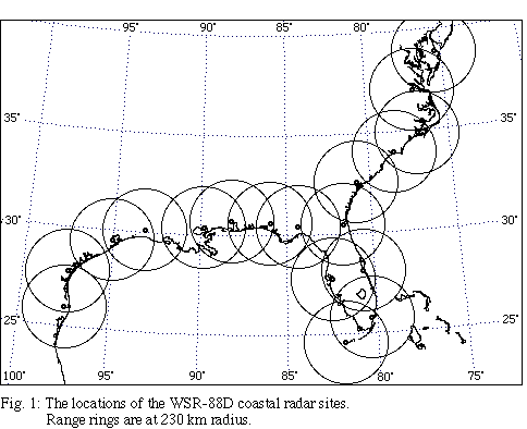
In addition to real-time surface wind analyses, a more complete description of the wind field in the inner core can be obtained with dual-Doppler techniques. The new network of Doppler radars being deployed by the National Weather Service (NWS), Depart ment of Defense, and Federal Aviation Administration (Fig. 1) may provide an opportunity in 1994 to obtain dual-Doppler data in a tropical cyclone.
The NWS plans to equip each radar with an Archive Level II recorder to store the base data used to create WSR-88D operational products. In precipitation or severe weather mode the radars will collect volume scans every 5 min.
Should a hurricane or strong tropical storm move within 230 km (Doppler range) of a coastal WSR-88D Doppler radar, a NOAA P-3 could obtain Doppler radar data that could be combined with data from the WSR-88D radar in dual-Doppler analyses (Fig. 2).
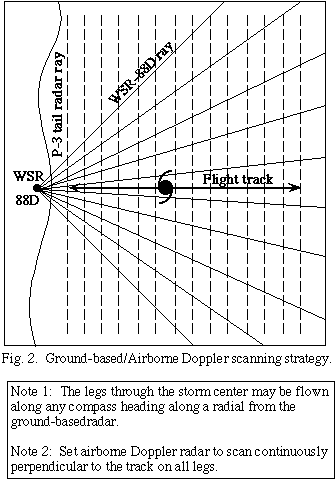
These analyses could resolve phenomena with time scales > 10 min (i.e. 2 samples), the minimum interval between WSR-88D volume scans. This time series of dual-Doppler analyses would be used to describe the storm's inner core wind field and its evolution.
The primary module of the experiment, the real-time module, will support real-time and post-storm surface wind analyses. Two dual-Doppler options can be flown if the storm is near a WSR-88D radar. The flight patterns will depend on the location of the storm relative to surface observing platforms and coastal radars.