Extended Cyclone Dynamics Experiment
(XCDX)
This document is divided into 4 sections:
Summary
This is a multi-option, multi-aircraft experiment which uses in-situ
and radar data from both WP-3Ds flying at 500 mb and the G-IV flying
at 200 mb to monitor the structure and evolution of a hurricane on
spatial scales ranging from the convective and mesoscale in the vortex
core (10-100 nmi [18-185 km] radius) to the synoptic-scale
(1,000 nmi [1,850 km] radius) in the surrounding large-scale environment
over a nominal period of 48 h. The WP-3D and G-IV data will be augmented
by flight-level data from Air Force WC-130s flying reconnaissance at 700 mb
within 110 nmi (200 km) of the center The goal of the experiment is a better
understanding of the ways in which lateral interactions between the vortex
and the synoptic-scale environment control hurricane intensity and motion.
[Return to table of contents above]
Program Significance
Starting in the early 1980s, the Vortex Dynamics Experiment was the focus of
observational studies of the evolution of the hurricane's inner core. It
accumulated an archive of more than 1000 radial passes in more than 20
different Atlantic and Eastern Pacific hurricanes. The main scientific result
was formulation of an observationally based model in which hurricane
intensity and structure changed through inward migration of convective
rings-annuli of convection that coincide with maxima of the swirling wind.
The observational convective ring model and the related theoretical model of
gradient-balance vortex response to imposed heating seem to describe most
aspects of the evolution of the hurricane's intense core. For example, when
two concentric convective rings occur, the outer may supplant the inner,
leading to cyclic intensity changes. Important unanswered research questions
are: What is the origin of convective rings and how do lateral interactions
with the surrounding atmosphere modulate their behavior.
Since 1991, HRD has received the flight-level observations from
routine reconnaissance flights by the IWRS-equipped WC-130Hs of the 54th
Weather Squadron. Although these observations have proven to be of excellent
quality, their value is compromised by a lack of vertical velocity,
microphysics, or radar reflectivity data. The USAF aircraft typically fix the
centers of TCs every 5-6 h. Each sortie makes two fixes and remains on
station for the time between them, flying figure-4 (ALFA) patterns at 850 or
700 mb (5,000 or 10,000 ft (1.5 or 3.0 km) altitude) with 150 nmi (278 km)
legs oriented along the cardinal directions. Between sorties, there is
usually a gap of 6-7 h during which no USAF aircraft is in the hurricane,
except near landfall when the National Hurricane Center requests fixes at 3 h
intervals. Experience with USAF observations from 1991-1995 has demonstrated
that they document the evolution of the hurricane core well, but that they
would be even more valuable with augmentation by occasional sorties of the
NOAA WP-3Ds.
The advent of the G-IV presents a long awaited opportunity to study
the dynamics of upper tropospheric waves that are hypothesized to control hurricane intensification through eddy influxes of angular momentum. Theoretically, the net result of this
import is not a spin up of the swirling wind but a strengthening of the semi-balanced near-tropopause outflow, which destabilizes the tropospheric column and invigorates the convection in the hurricane core. Rapid intensification, apparently triggered by
this mechanism, is a one of the most challenging problems that forecasters face. Recent theoretical insights into the eddies themselves indicates that they are Rossby waves that propagate on the radial gradient of axisymmetric relative vorticity in the
hurricane. We think that we know how the eddies work, and the G-IV provides the ideal vehicle to go looking for them.
[Return to table of contents above]
Objectives
This experiment is designed to investigate how eddy influxes of angular momentum affect hurricane intensity by examining the changes in three-dimensional kinematic and thermal structure within ~540 nmi (1,000 km) radius over approximately a 48-60 h period
.
The XCDX experiment can be coordinated with the Hurricane Surveillance Mission flown by the G-IV. Two options have been devised: (1) Vortex; and (2) Synoptic.
The Vortex Option is designed to sample the vortex core intensively with less emphasis on data collection in the surrounding large-scale environment. This option uses the flight-level data and dropsondes from the WP-3Ds and the G-IV, Doppler and
reflectivity radar from the WP-3Ds, and Air Force flight-level data to monitor the temporal changes of the axisymmetric vortex over a period of up to 60 h.
Conversely, the Synoptic Option emphasizes the sampling of the large-scale environment while placing less of a priority on obtaining data in the vortex core. This option uses the flight-level, radar reflectivity, and Doppler data, along with dropsondes
from the WP-3Ds to map the synoptic-scale environment surrounding the vortex. At the same time the flight-level data and dropsondes from the G-IV combined with Air Force flight-level data will be used to monitor the temporal changes of the axisymmetric
vortex over a period of up to 48 h to study the eddies that mediate the synoptic-scale forcing.
[Return to table of contents above]
Mission Description
There are two options included in this experiment: a Vortex option and a Synoptic option.
Vortex Option:
This option of the Extended Cyclone Dynamics Experiment (XCDX) uses the USAF C-130s to observe the evolution of the hurricane core while the WP-3Ds fly long radial legs above them to collect radar data and observe the interaction with the synoptic-scale
environment, and, if available, the G-IV circumnavigates the storm in the upper troposphere dispensing GPS-sondes. The ideal target is a northward moving hurricane that has a fairly small Central Dense Overcast (CDO) and is expected to interact with
vertical shear, an approaching mid-latitude trough, or a upper-level low.
The WP-3Ds will fly at the 500 mb isobaric level (18,000 ft [5 km]) in a pattern of three equilateral triangles with common vertices at the hurricane's center.
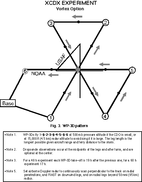
The nominal leg length will be 250-300 nmi (460-550 km), but the size of the pattern will be adjusted to make the legs as long as possible given the available aircraft range. The WP-3D will deploy GPS-sondes in a symmetrical pattern to map the vertical
structure of the secondary circulation below flight level and in the eye to study the thermodynamic transformation there. The XCDX will require three maximum-endurance sorties in 48 h or four in 60 h by alternating aircraft and crews. Crew-rest considera
tions
dictate that take-off times will shift as much as 3 h later on subsequent days. The aircraft will spend a third or a quarter of its time in icing conditions under the CDO, which may compromise range.
The G-IV, if available, will fly a hexagonal circumnavigation of the storm at 600 nmi (1110 km) radius, dispensing up to five dropsondes on each of the six sides of the pattern.
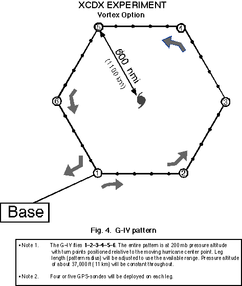
Since the purpose of the pattern will be to observe asymmetric structure and compute eddy correlations, the turn points will need to move with the hurricane, placing a premium on accurate navigation.
[Return to table of contents above]
Synoptic Option:
Data will be collected within ~540 nmi (1,000 km) radius of the vortex center over approximately a ~48 h period when an unsheared or well organized tropical storm or hurricane is interacting with an upper-level trough or cold low. Since in this option the
goal is to document the structural changes of an intensifying vortex, it is desirable that the system be moving along an upper-level trough, since this minimizes the chance that the system will experience extensive shearing. Successful completion of
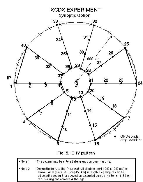
this option requires that the G-IV, if available, fly a cloverleaf type pattern with legs of ~240 nmi (450 km) at maximum altitude (41,000 ft [~200 mb]) dispensing GPS-sondes along the way (Fig. 5)
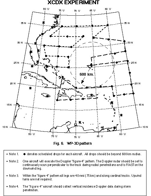
The two WP-3D aircraft would fly a synoptic-flow type pattern at 21,000 ft (~400 mb) dispensing GPS sondes between ~320-540 nmi (600-1,000 km) radius to document the large-scale structure outside the region sampled by the G-IV aircraft (Fig. 6). One of
the two WP-3D aircraft would fly through the center and collect Doppler and reflectivity data.
[Return to table of contents above]
Back to the Hurricane Field Program Experiment page.