This document is divided into 4 sections:
[Return to table of contents above]
Synoptic Flow experiments were conducted on 18 occasions from 1982-93. Recent research at HRD, NCEP, and GFDL with this sample of cases demonstrates conclusively that the ODW data produce significant improvements in the operational models that are the primary guidance for TPC/NHC's official track forecasts. For consensus (averaged) forecasts from the three primary operational dynamical models (HRD's barotropic VICBAR model, GFDL's nested grid model, and NCEP's global spectral model), the ODWs were responsible for statistically significant 12-60 hour track forecast improvements of 16%-30%. These improvements are at least as large as the accumulated improvement in operational forecasts achieved over the last 20-25 years.
The size of these improvements suggests that operational GPS-sonde missions will be a highly effective way to reduce the costs associated with overwarning. Hurricane warnings are usually issued 18-24 hours before landfall for a length of coastline averaging 300 nmi (555 km). The swath of damaging winds and tides caused by hurricanes that strike land, however, is generally <100 nmi (185 km). Thus, current forecasting skill results in an overwarning zone of ~200 nmi (370 km) that is a trade-off betwe en maximizing warning lead time and keeping the warning area as small as possible. In 1990, TPC/NHC estimated that the preparation costs alone incurred by the public placed under a hurricane warning exceed $90,000 per km of coastline. By comparison, the cost of a three-aircraft dropwindsonde mission using 70 GPS-sondes (at $400 apiece) and 27 hours of flight time (at $2,800 per hour) is about $104,000. If forecasters are able to reduce the over-warning area by only 5% (20 km (12 nmi)) by taking advantage of GPS-sonde-improved numerical guidance, the cost of obtaining the data will be well worth the expenditure.
In addition to direct operational benefits of the Synoptic Flow experiments, diagnostic case studies of the ODW observations have led to improvements in our basic understanding of hurricane motion. Analyses of the existing data sets have helped to docume nt the relationship between vortex motion and the environmental flow and have provided the first observational evidence of the beta-gyres commonly found in barotropic models. A multi-scale, nested analysis of the Gloria data set has also been completed. This analysis identified a "steering envelope" in the deep-layer-mean flow just outside Gloria's eyewall. The Gloria analyses have also been used to document, for the first time, the potential vorticity (PV) distribution in a hurricane's core and environment.
Current work involving the inversion of Gloria's PV distribution is expected to provide a powerful new tool for diagnosing the synoptic features responsible for a given hurricane's steering flow. Preliminary results indicate that upper level PV features may dominate, and may act from large distances from the hurricane's center. Synoptic Flow experiments using the G-IV and WP-3Ds simultaneously will offer an unprecedented opportunity to document these features.
[Return to table of contents above]
The ODW's have been shown to be capable of improving hurricane track forecasts; however, the optimal deployment strategy is unknown. The increased range and altitude capability of a three-aircraft coordinated pattern, coupled with the PV inversion tools currently being developed, will allow the determination of optimal deployment strategies. Other research, which is just under way, is the initialization of multi-level models with the dropwindsonde data. With their added complexity, the current sample of cases is probably not large enough to adequately study the behavior of these models. These data sets will also be used to study the influence of synoptic-scale fields on changes in vortex intensity and track and to assess satellite-derived products.
[Return to table of contents above]
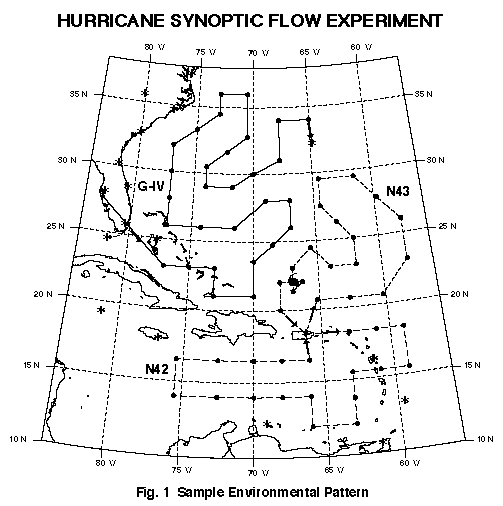
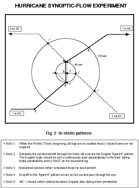
A sample mission is shown below.
The two WP-3D aircraft and the G-IV will begin their missions at the same time. Subject to safety and operational constraints, each WP-3D will climb to the 500-mb level (about FL 180) or above, then proceed, step-climbing, along the routes assigned durin g preflight. It is particularly important that both aircraft climb to and maintain the highest possible altitude as early into the mission as aircraft performance and circumstances allow, and attain additional altitude whenever possible during the mission . GPS-sondes are released in one of two modes. Beyond 40 nmi (75 km) from the storm center, drops are made at pre-assigned locations, generally every 25 min or 120 nmi (222 km). These drop locations are provided with the particular mission flight tracks 2 h before blockout. Within 40 nmi (75 km) of the hurricane's center, drop locations are specified relative to the center's position (e.g., 40 nmi (75 km) north of the eye). During in-storm portions of the mission, drops will be made with possible spacings < 8 min or 40 nmi (75 km). Efforts should be made to avoid making drops in heavy precipitation, unless necessary. Aircraft turns are not expected to affect the GPS-sonde wind accuracy, but we expect to continue the practice of making drops AFTER THE TURN IS COMPLETE.
Usually, one aircraft will fly through the hurricane center and execute a Doppler figure 4 pattern. This aircraft's Doppler radar should be set to scan perpendicular to the aircraft track. "Hard" center fixes are not desirable. On the downwind leg of the figure 4, the Doppler should be set to record forward and aft (F/AST) continuously. If both aircraft penetrate the storm, the figure 4 pattern will generally be executed by the second aircraft through the storm, and the first aircraft through will collect vertical incidence Doppler data. Coordination with potential USAF reconnaissance is necessary to ensure adequate aircraft separation. The in-storm portion of the missions is shown schematically in Fig. 2, although the actual orientation of these tracks may be rotated.
Of paramount importance is the transmission of the GPS-sonde data to NCEP and TPC/NHC for timely incorporation into operational analyses, models, forecasts, and warnings. Operational constraints dictate an 0600 or 1800 UTC blockout time, so that the GPS-sonde data will be included in the 1200 or 0000 UTC analysis cycle. Further, limiting the total block time to 9 h allows adequate preparation time for aircraft and crews to repeat the mission at 24-h intervals. These considerations will ensure a fixe d, daily real-time data collection sequence that is synchronized with NCEP and TPC/NHC's analysis and forecasting schedules. If the missions are not to be repeated, then requested block times may exceed 9 h. In addition to the GPS sonde data, three to four RECCO's per hour should be taken and transmitted during each mission.
[Return to table of contents above]