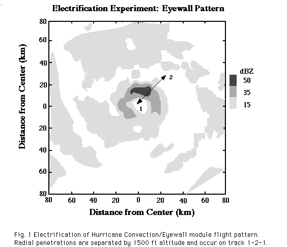
The out and back pattern (1-2-1 in See Fig. 1) should be repeated until the aircraft reaches its maximum attainable altitude. The Doppler radar should be operated in a 360 degree sc an mode during the radial passes. Upon completion of the radial legs, an equilateral triangle Doppler pattern will be executed, starting from inside the eye. The starting azimuth (See Fig. 1) will be 60 degree upstream from the upstream edge of the stron gest radar reflectivity feature in the eyewall or innermost convection. The legs should be ~80 km long, with the inbound leg connected to the outbound leg by a downwind leg. The inbound leg should penetrate the convection at the upstream edge of the str ong reflectivity area previously identified. Each triangle will require 10-20 min. to complete, depending upon the leg length.

Each downwind pass (Fig. 2, 1-2) should maintain a track along the axis of the band and be about 50 nmi long and 1500 ft higher (lower) than the previous one. During this portion of the pattern, the Doppler radar should make 360 degree scans normal to the aircraft track. After the downwind pass is completed, the aircraft should exit the band on the outer side, climb (descend), and return (Fig. 2, 3-4) upwind to the start of the band. The Doppler data will be obtained on the upwind pass using the F/AST met hod. This pattern will require about 20 minutes to execute. Pass length may be altered as circumstances dictate. Repeat this pattern until the maximum altitude is reached, or seek a new area as desired. As an alternate, a zig-zag path downwind through the convective band may be flown if necessary for flight safety.
(NOTE: If the feature of interest is not translating, radial legs should be flown on a constant track instead of a constant heading. The length of the radial legs depends upon the diameter of the eye and the width of the rainband, respectively. Turns shou ld be initiated into the wind.)

Together, these data sources and techniques should lead to a better understanding of the characteristics of the convective processes that lead to lightning in hurricanes and, poss ibly, to intensity changes of the storms.
For this option, the aircraft will initially fly a survey figure 4 pattern (See Fig. 3a) at ~5.5 km altitude.

The figure 4 pattern would be completed in 1.5-2.0 hours with radial legs 150 km in length. The second part of this option (See Fig. 3b) concentrates on rainbands that are located within the useful range of the NLDN.
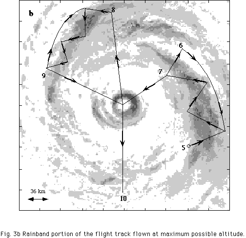
Upon exiting the eye at 4, the aircraft should climb as high as possible on the way to the rainband of interest (5). A sawtooth pattern is flown downwind (Doppler operating in standard mode) with repeated crossings of the rainband to 6. We prefer to fly directly down the band as noted in Fig. 2, but for reasons of safety, a sawtooth pattern may be flown. An upwind leg, flown outside of the band, is performed with the tail radar operating in the F/AST mode. The saw tooth pattern across the band is repeated with an exit toward the eye at 7. After entering the eye, the aircraft turns toward the second rainband at 8. The sawtooth crossings and the F/AST downwind leg are repeated as in the first rainband. A final center fix is made (time permitting) before returning to base from 10. About one hour should be spent in each of the rainbands. If only one rainband is present within the useful range of the NLDN, a second study of the same band can be performed after a circuit through the storm center.