Effects of Synoptic Surveillance on model forecasts for
Hurricane Frances.
Quicktime movie of DLM wind analyses
Quicktime movie of DLM wind data
initial
increments
| August 29, 2004 | 18 Z | ||||
| August 30, 2004 | 00 Z | 06 Z | 12 Z | 18 Z | |
| August 31, 2004 | 00 Z | 06 Z | 12 Z | 18 Z | |
| September 01, 2004 | 00 Z | 06 Z | 12 Z | 18 Z | |
| September 02, 2004 | 00 Z | 06 Z | 12 Z | 18 Z | |
| September 03, 2004 | 00 Z | 06 Z | 12 Z | 18 Z | |
| September 04, 2004 | 00 Z | 06 Z | 12 Z |
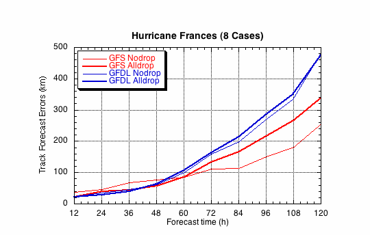
Figure 1a. Track forecast errors for the no dropwindsonde (NO or NN) and the all dropwindsonde (AL) runs for the GFS and GFDL models for the Hurricane Frances synoptic surveillance missions.
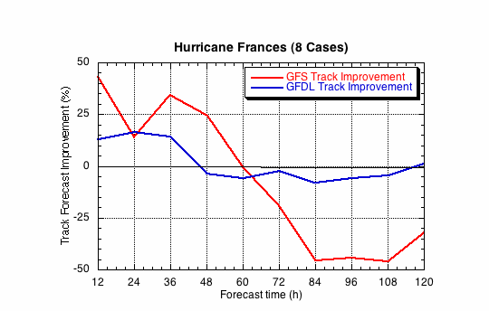
Figure 1b. Track forecast improvements for the GFS and GFDL models for the the Hurricane Frances synoptic surveillance mission.
(a)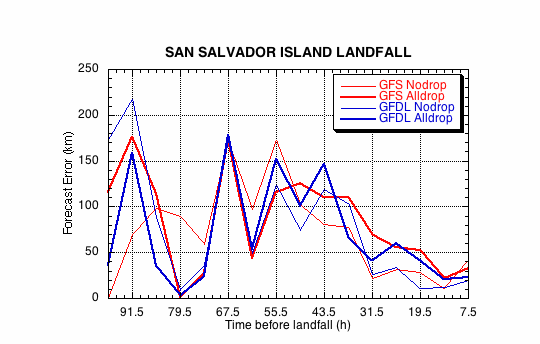
(b)
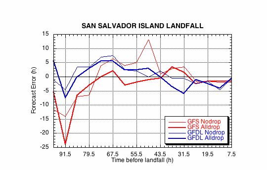
Figure 2. Forecast errors for the landfall of Hurricane Frances on San Salvador Island, Bahamas, in the (a) cross- and (b) along-track directions for the no dropwindsonde (NO or NN) and the all dropwindsonde (AL) runs for the GFS and GFDL models.
(a)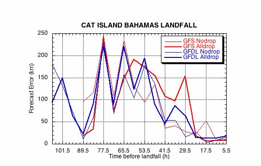
(b)
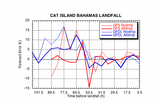
Figure 3. Forecast errors for the landfall of Hurricane Frances on the northern end of Cat Island, Bahamas, in the (a) cross- and (b) along-track directions for the no dropwindsonde (NO or NN) and the all dropwindsonde (AL) runs for the GFS and GFDL models.
(a)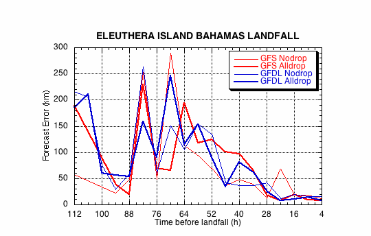
(b)
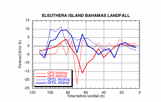
Figure 4. Forecast errors for the landfall of Hurricane Frances on Eleuthera Island, Bahamas, in the (a) cross- and (b) along-track directions for the no dropwindsonde (NO or NN) and the all dropwindsonde (AL) runs for the GFS and GFDL models.
(a)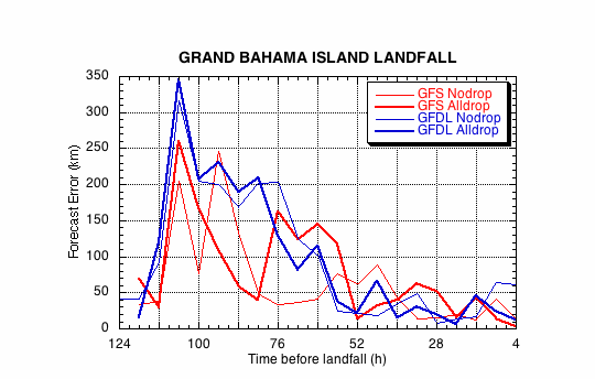
(b)
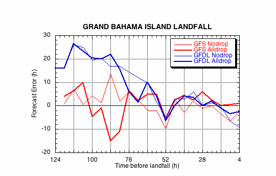
Figure 5. Forecast errors for the landfall of Hurricane Frances on Grand Bahamas Island, Bahamas, in the (a) cross- and (b) along-track directions for the no dropwindsonde (NO or NN) and the all dropwindsonde (AL) runs for the GFS and GFDL models.
(a)
(b)
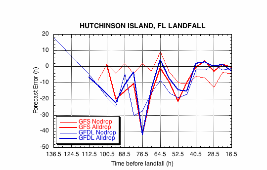
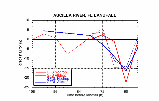
Figure 6. Forecast errors for the landfall of Hurricane Frances at the southern end of Hutchinson Island, FL, in the (a) cross- and (b) along-track directions for the no dropwindsonde (NO or NN) and the all dropwindsonde (AL) runs for the GFS and GFDL models.
(a)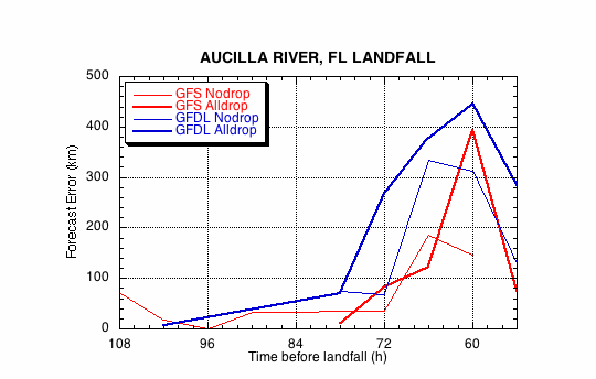
(b)