Effects of Synoptic Surveillance on model forecasts for
10 September 1999 1200 UTC
FLOYD.
QuickTime movie of DLM wind model
forecasts
QuickTime movie of DLM wind data
increments
| TRACK (km) | ||||||||||||||||||||||||||||||||||||||||||||||||||||||||||||||||||||||||||||||||||||||||||||||||||||||||||||||||||||||||||||||||||||||||||||||||||||||||||||||||||||||||||||||||||||||||||||||||||||||||||||||||||||||||||||||||||||||||||||
| MODEL | 12 h | 24 h | 36 h | 48 h | 60 h | 72 h | 84 h | 96 h | 108 h | 120 h
|
| AVNN | 147. | 236. | 257. | 214. | 247. | 278. | 304. | 269. | 326. | 392.
| AVAL | 159. | 216. | 265. | 310. | 312. | 331. | 365. | 382. | 331. | 371.
| %IMP | -8% | 8% | -3% | -45% | -26% | -19% | -20% | -42% | -2% | 5%
|
| GFNO | 132. | 207. | 259. | 241. | 176. | 136. | 143. | 134. | 104. | 117.
| GFAL | 118. | 156. | 164. | 130. | 75. | 33. | 32. | 81. | 170. | 266.
| %IMP | 11% | 25% | 37% | 46% | 57% | 76% | 78% | 40% | -63% | -117%
| INTENSITY (kt)
| MODEL | 12 h | 24 h | 36 h | 48 h | 60 h | 72 h | 84 h | 96 h | 108 h | 120 h
|
| AVNN | -44. | -57. | -44. | -64. | -88. | -93. | -70. | -57. | -66. | -44.
| AVAL | -34. | -42. | -32. | -55. | -66. | -77. | -51. | -31. | -34. | -21.
| %IMP | 23% | 26% | 27% | 14% | 25% | 17% | 27% | 46% | 48% | 52%
|
| GFNO | 34. | 22. | 31. | 2. | -5. | -20. | 0. | 8. | -6. | 13.
| GFAL | 32. | 20. | 31. | 12. | -10. | -20. | 0. | 11. | 4. | 1.
| %IMP | 6% | 9% | 0% | -500% | -100% | 0% | 0% | -38% | 33% | 92%
|
| SHNO | -5. | -16. | -2. | -17. | -35. | -42. | -21. | -9. | -17. | -1.
| SHAL | -6. | -19. | -6. | -24. | -43. | -50. | -31. | -20. | -29. | -13.
| %IMP | -20% | -19% | -200% | -41% | -23% | -19% | -48% | -122% | -71% | -1200%
|
| DSNO | -5. | -16. | -2. | -17. | -35. | -42. | -21. | -9. | -17. | -1.
| DSAL | -6. | -19. | -6. | -24. | -43. | -50. | -31. | -20. | -29. | -13.
| %IMP | -20% | -19% | -200% | -41% | -23% | -19% | -48% | -122% | -71% | -1200%
| | ||||||||||
| 14/1200 UTC 25.4N 76.3W Near Alice Town, Eleuthera 96 h into the forecast | |||||||||||||||||||||||||||||||||||||||||||||||||||||||||||||||||||||||||||||||||||||||||||||||||||||||||||||||||||||||||||||||||||||||||||||
| MODEL | LAT | LON | TIME | ERROR | LOCATION
|
| AVNN | 23.48 | 73.58 | 92.5 | 348.1 | Near Samana Cay, Bahamas
| AVAL | 23.28 | 73.61 | 97.0 | 360.0 | Near Samana Cay, Bahamas
| %IMP | 71% | -3%
|
| GFNO | 26.98 | 76.40 | 105.5 | 175.8 | Near Abaco Island, Bahamas
| GFAL | 24.42 | 74.42 | 84.5 | 218.5 | Near San Salvador, Bahamas
| %IMP | -21% | -24%
|
| MODEL | LAT | LON | TIME | ERROR | LOCATION
|
|
|
| AVNN | 25.17 | 77.95 | 116.5 | 151.6 | Andros Island, Bahamas
| AVAL | 25.85 | 77.49 | 117.5 | 63.4 | Eleuthera Island, Bahamas
| %IMP | -7% | 58%
| GFNO | 26.98 | 76.40 | 105.5 | 102.7 | Near Abaco Island, Bahamas
| GFAL | 26.45 | 78.86 | 105.0 | 176.0 | Grand Bahama Island, Bahamas
| %IMP | 20% | -71%
|
|
16/0630 UTC 33.8N 78.0W Near Cape Fear, NC 138.5 h into the forecast
| MODEL | LAT | LON | TIME | ERROR | LOCATION
|
|
| AVNN | No landfall forecast
| AVAL | No landfall forecast
| %IMP |
|
| GFNO | No landfall forecast
| GFAL | 27.87 | 80.47 | 114.0 | 699.7 | Micco, FL
| %IMP |
| | |||||||||||||||||||||||||||||||||||||
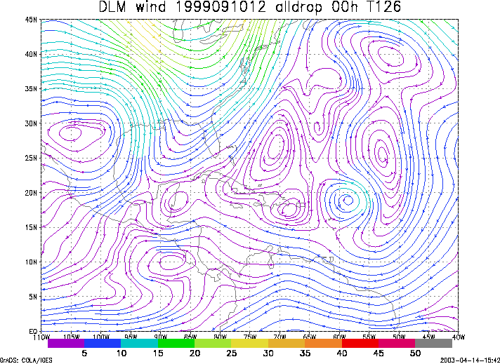
Figure 1. NCEP 850 - 200 hPa mean wind analysis for 10 September 1999 1200 UTC (Hurricane Floyd).
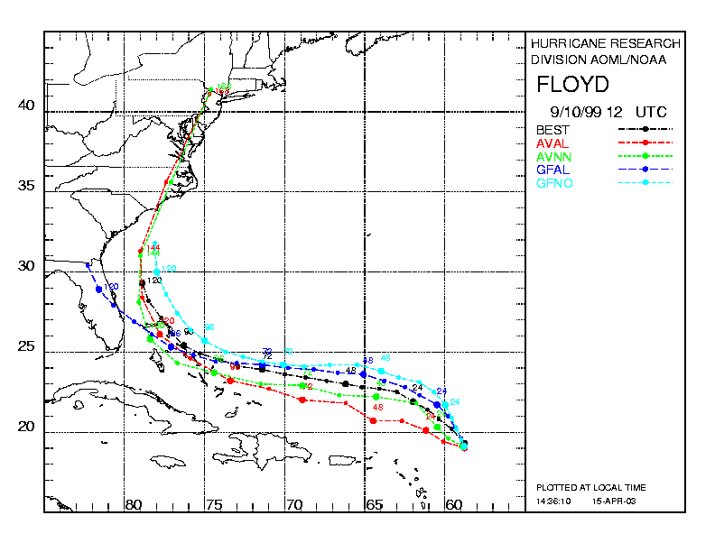
Figure 2. Track forecasts for the no dropwindsonde (NO or NN) and the all dropwindsonde (AL) runs for the AVN and GFDL models initialized on 10 September 1999 1200 UTC. The best track is shown in black.
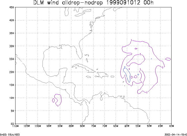
Figure 3. Initial condition differences in the 850 - 200 hPa mean wind between the no and all dropwindsonde cases for 10 September 1999 1200 UTC.
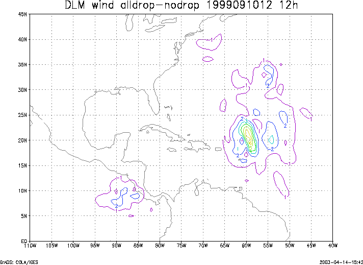
Figure 4. 12-h forecast differences in the 850 - 200 hPa mean wind between the no and all dropwindsonde cases for 10 September 1999 1200 UTC.