 Updraft Effects on Z-R RelationsUpdraft Effects on Z-R Relations
There were numerous significant updrafts, however, and their effect on the Z-R relations was to shift the data points so the resultant regression line is to the left of that for the whole population. To illustrate the effects of updrafts on the Z-R relations the sample was limited to the upper 5% (268 samples) of the 6-s mean <w> > 2.0 m/s.
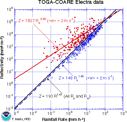
Because much of the rain is moving upward in updrafts, in convection we should consider the flux of precipitation, or rain water, and not rainfall rate per se. For example, for the 5% of points with <w>>2.0 m/s, the sum of the precipitation flux (sum R0, sum R w) changes from 4990.4 to 1240.1 mm/hr (i.e., only 25% of the rain is falling) upon the application of updraft velocity, and in a number of samples virtually all of the precipitation hydrometeors are rising. Moreover, the large mass of water which is rising will fall out later at places far removed from the measurement volume, the smaller the drops the further away. Of course, some of these small drops will not survive evaporation. The drop distributions will undergo significant evolution from their initial formation in convective updrafts and their complex trajectories to the surface.
Another way of looking at the effect updrafts have on the resultant rainfall rate is by plotting <w> versus the ratio Rw/R 0.

 References
 marks@aoml.noaa.gov