Mission Summary
20021014N1 Aircraft 49RF
Synoptic Surveillance flight
around Trop. Depr. #14 2002
| Sonde Scientist | Sim Aberson |
| Sonde Scientist | Sim Aberson |
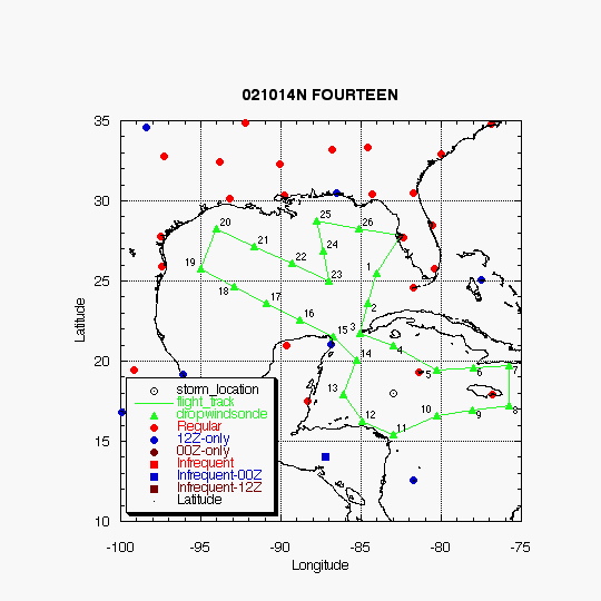
The G-IV jet, with scientific crew of Sim Aberson, conducted an NHC-tasked synoptic surveillance mission around TD #14 at the nominal time of 00 UTC/October 14. Take-off time was at 1:30 PM EDT from MacDill AFB and landed at 10 PM EDT in MacDill AFB, FL.
Mission Summary Log :
Important information relayed to specialist JARVINEN at 01:45 UTC
1. Drop 5 had 29 kt at the surface, near Cayman Islands.
2. Pressures near Cuba about the same as satellite estimate of central pressure. Surface pressures of 1007 lower than advisory pressures.
3. Cirrus above 45,000 ft over center of depression. Never seen cirrus so high.
4. There is a 200 mb anticyclone just east of the center. There does not seem to be as much shear as expected. No sign of anticyclone at 250mb. The shear seems to be between 400 and 250mb.
5. Storm circulation extends to 400mb, maybe 300mb.
6. Storm circulation is rather large at surface, extending north of Yucatan.
7. Quite moist all around storm.
8. Weak DLM ridge to northeast, strong trough to west should pull storm northeastward.
9. Weak closed circulation at 500mb north of western tip of Cuba.
10. Cold front from surface to 850mb from mouth of the Mississippi SSWward. Only dry air seen is behind this front.
11. SATCOM worked
| DROP LOCATIONS | |||
| Drop # | LAT (d m) |
LON (d m) |
TIME (h:mm) |
| 1 | 25 30 | 84 00 | 0:22 |
| 2 | 23 37 | 84 32 | 0:38 |
| 3 | 21 45 | 85 05 | 0:54 |
| 4 | 21 00 | 83 00 | 1:11 |
| 5 | 19 24 | 80 17 | 1:37 |
| 6 | 19 34 | 78 01 | 1:55 |
| 7 | 19 45 | 75 45 | 2:13 |
| 8 | 17 15 | 75 45 | 2:33 |
| 9 | 16 55 | 78 01 | 2:51 |
| 10 | 16 35 | 80 17 | 3:10 |
| 11 | 15 25 | 83 00 | 3:34 |
| 12 | 16 14 | 84 56 | 3:51 |
| 13 | 17 57 | 86 04 | 4:07 |
| 14 | 20 02 | 85 15 | 4:26 |
| 15 | 21 30 | 86 45 | 4:42 |
| 16 | 22 33 | 88 48 | 5:01 |
| 17 | 23 37 | 90 52 | 5:19 |
| 18 | 24 41 | 92 56 | 5:37 |
| 19 | 25 45 | 95 00 | 5:56 |
| 20 | 28 15 | 94 00 | 6:18 |
| 21 | 27 10 | 91 40 | 6:38 |
| 22 | 26 04 | 89 19 | 6:58 |
| 23 | 25 00 | 87 00 | 7:18 |
| 24 | 26 52 | 87 22 | 7:33 |
| 25 | 28 45 | 87 45 | 7:49 |
| 26 | 28 17 | 85 08 | 8:09 |
| TRACK DISTANCES | ||||||
| Drop # | LAT (d m) |
LON (d m) |
RAD/AZM (nm/dg) |
LEG (nm) |
TOTAL (nm) |
TIME (h:mm) |
| 0 | MACDILL | 0. | 0. | 0:00 | ||
| 1 | 25 30 | 84 00 | 164. | 164. | 0:22 | |
| 2 | 21 45 | 85 06 | 234. | 398. | 0:54 | |
| 3 | 21 00 | 83 00 | 180/ 0 | 130. | 527. | 1:11 |
| 4 | 19 25 | 80 17 | 180/60 | 184. | 712. | 1:37 |
| 5 | 19 45 | 75 45 | 265. | 977. | 2:13 | |
| 6 | 17 15 | 75 45 | 150. | 1127. | 2:33 | |
| 7 | 16 35 | 80 17 | 180/120 | 269. | 1396. | 3:10 |
| 8 | 15 25 | 83 00 | 155/180 | 174. | 1570. | 3:34 |
| 9 | 16 15 | 84 57 | 155/225 | 125. | 1695. | 3:51 |
| 10 | 17 57 | 86 05 | 180/269 | 122. | 1817. | 4:07 |
| 11 | 20 02 | 85 16 | 180/315 | 134. | 1951. | 4:26 |
| 12 | 21 30 | 86 45 | 123. | 2074. | 4:42 | |
| 13 | 25 45 | 95 00 | 538. | 2612. | 5:56 | |
| 14 | 28 15 | 94 00 | 160. | 2772. | 6:18 | |
| 15 | 25 00 | 87 00 | 442. | 3215. | 7:18 | |
| 16 | 28 45 | 87 45 | 229. | 3444. | 7:49 | |
| 17 | MACDILL | 299. | 3743. | 8:30 | ||
Return to Mission page.