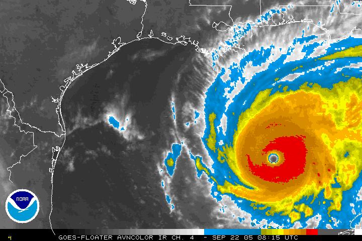
Figure 1. GOES-East infrared image valid 0815 UTC September 22.
| Rob Rogers | LPS |
| Eric Uhlhorn | AXBT |
| Shirley Murillo | Dropsonde |
| Ed Walsh (SRA) | Observer |
| Dave Jorgensen (NSSL) | Observer |
| Randy Tebeest, Mark Nelson | Pilots |
| Joe Kippel | Flight Engineer |
| Tim Gallagher | Navigator |
| Marty Mayeaux | Flight Director |
| Terry Lynch, Damon San Souci, Jim Barr | Engineers |
N43RF will fly a mission with multiple objectives. The NOAA P3 will leave MacDill AFB,FL at 9:00 AM EDT. The primary objective is to conduct an NHC-tasked fix/SFMR mission with fix responsibilities at 15, 18, and 21 UTC. Piggy-backed onto this tasked mission is a module to map out the sea surface temperature and subsurface temperature structure with 18 AXBT's dropped at locations meant to coincide with where the Air Force dropped drifting buoys the previous day. Eight of those AXBT's will be deployed in combination with HRD dropsondes.
RAINEX objectives will also be met by providing lower-fuselage radar coverage and by dropping RAINEX sondes at the flight-level wind maximum in the eyewall, and, if there is a secondary eyewall, in the secondary wind maximum and in the moat region between the two eyewalls. NHC sondes will also be dropped at the surface wind maximum in the eyewall and at the center of the storm.
The NOAA P3 will recover at MacDill AFB, FL at 6:00 PM EDT.
Mission Summary :
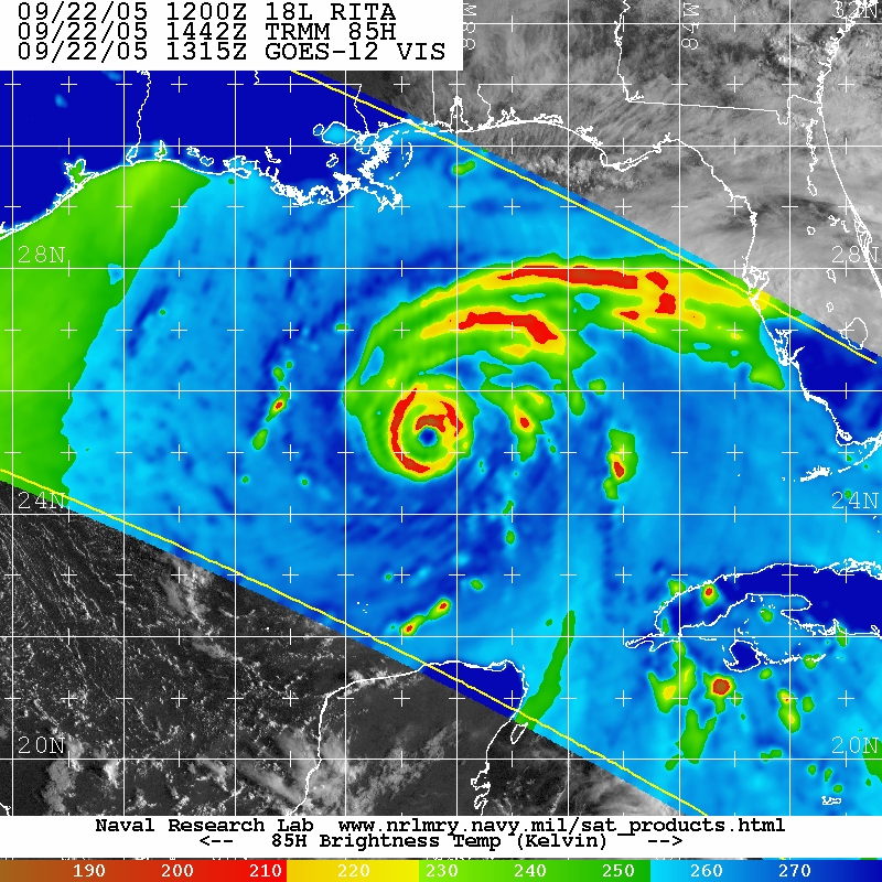
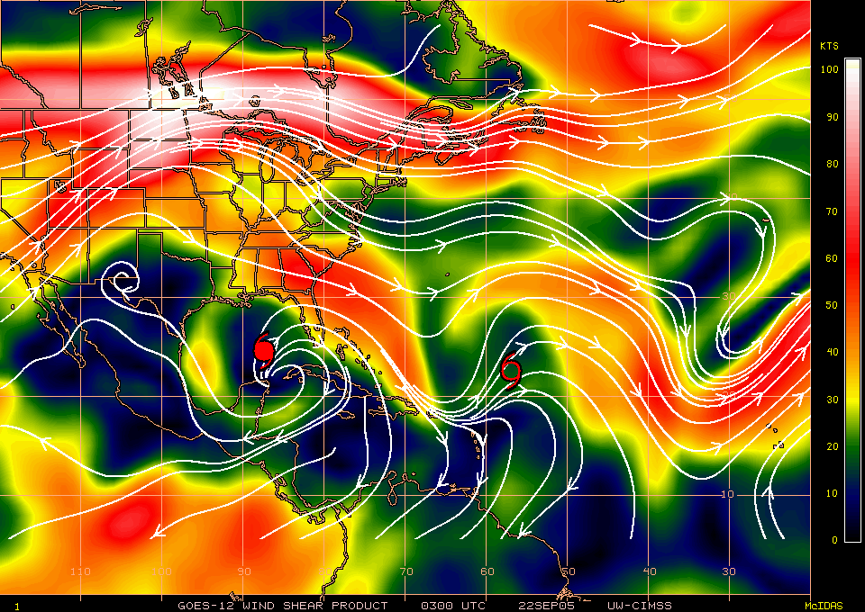
Hurricane Rita continues as a Category 5 today. Infrared satellite imagery (Fig. 1) shows a symmetric, intense storm. Outflow may be somewhat restricted on the south side. A TRMM overpass from the morning (Fig. 2) shows a concentric eyewall structure and two well-defined bands extending around the north and to the east side of the storm. There is some southerly vertical shear impacting the storm (Fig. 3), but it is light. The forecast call for Rita to maintain its intensity or weaken some before making landfall along the northern Texas coast sometime early Saturday morning.

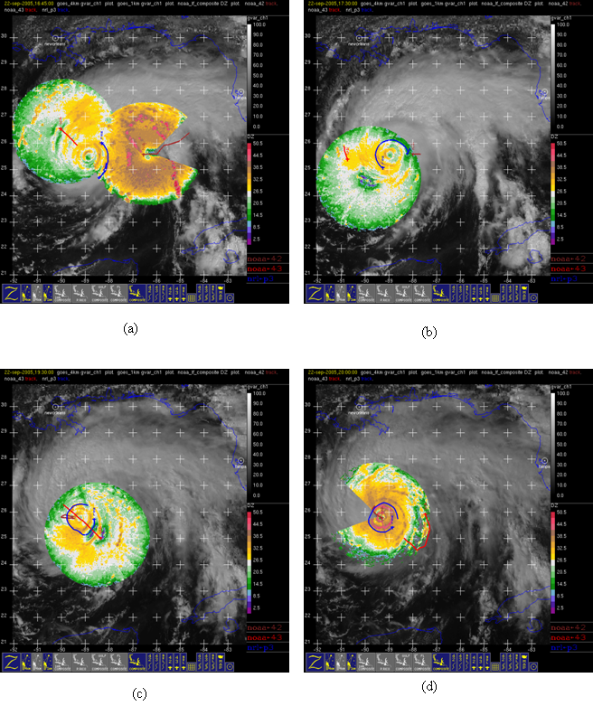
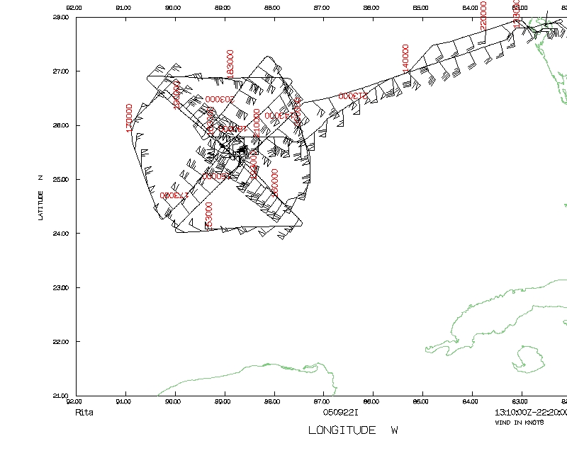
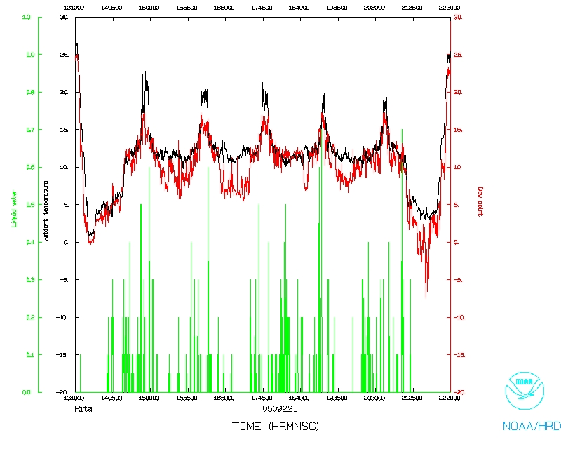
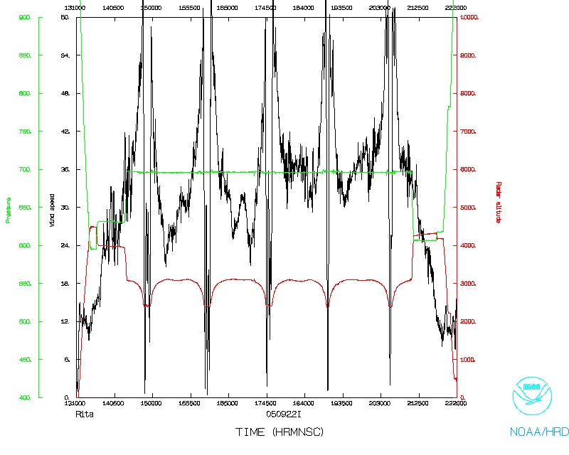
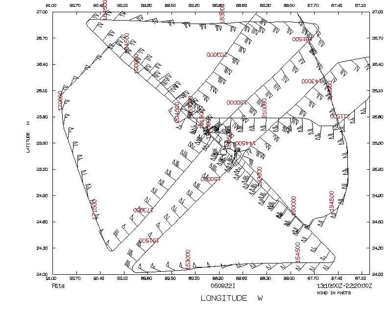
The mission for N43RF proceeded as intended. The NOAA P3 left MacDill AFB,FL at 9:10 AM EDT. Because the storm was moving a little more slowly than anticipated, the pattern was extended by about 50 nm on the northwest side (Fig. 4) to allow for dropsonde and BT drops coincident with the placement of the Air Force buoys. The figure-4 was repeated after that northwest leg, beginning on the southwest side instead of the northeast side. After finishing that figure-4 and ending up on the southeast side, N43RF came north on a downwind leg to a point northeast of the storm. It then flew its last pass inbound, then outbound to the east, and finally returning to base. There were a total of 8 HRD sonde/AXBT combination drops, plus ten more AXBT's were dropped. During the flight some slight weakening from the previous day was noted, though MSLP continued to hover between 910 and 915 hPa from GPS sonde drops. The eye did remain clear however, with a good stadium effect evident. Low-level clouds were more prevalent in the eye, though, and the inner eyewall was open on the southeast side. Peak flight-level winds were 135 kt in the northeast eyewall, while peak surface winds (measured by the SFMR) were 120 kt in the northwest eyewall. The storm developed a classic concentric eyewall pattern. With each successive pass the development of an outer wind maximum was sampled. An interesting pattern was noticed, however, in that the outer wind maximum was clearer on the south side than on the north side. By the end of the flight, the reflectivity gradients
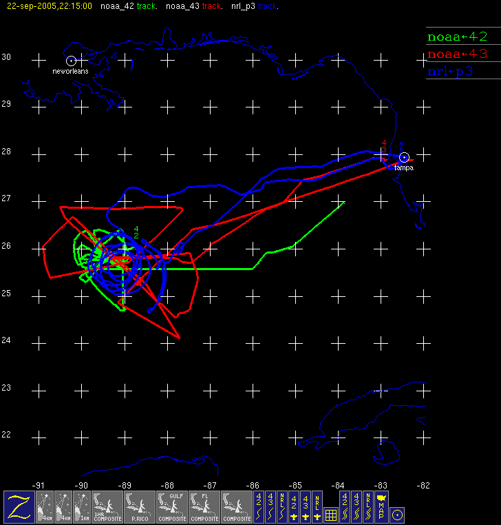
had sharpened up significantly and the flight-level winds in the inner and the outer eyewall were of comparable magnitude, both on the south and the north side of the storm. There was a marked asymmetry in the SFMR winds noted in the inner eyewall, with surface winds of 120 kt on the northwest side and only 85 kt on the southeast side. Sea-surface temperatures ahead of the storm were 29-29.5 C with a deep mixed layer. These dropsonde and BT measurements, in conjunction with the buoys deployed by the Air Force, should provide valuable data of the oceanic conditions underneath and in advance of a major hurricane in the Gulf. In addition to N43RF, N42RF and the NRL P-3 were also in the storm, providing detailed coverage of the inner core as well as the outer rainband regions (cf. Fig. 4). N42RF was flying an Ocean Winds experiment, so it spend much of its time sampling the eyewall (both inner and outer) in radial legs. There were some instances where it flew downwind legs over a small azimuthal range. The lower fuselage radars from both N42RF and N43RF were used to guide the NRL P-3 in its RAINEX mission. The NRL P-3 flew a pattern that should yield rich datasets for future research. It flew in the moat region in between the inner and outer eyewall (Fig. 5), completing several circumnavigations of the inner eyewall. While this was occurring, N42RF was sampling the eyewall and moat region at high temporal resolution, while N43RF was providing the broader context of the hurricane with its tasked figure-4 patterns. The proximity of the NRL P-3 to the inner eyewall during its circumnavigations was generally less than 10-15 km, which would provide excellent tail Doppler coverage of this feature. During these patterns, N43RF was dropping sondes within the inner eyewall, along the inner edge of the outer eyewall, and within the moat region between the inner and outer eyewall, the NRL P-3 was dropping sondes all along the moat region during its circumnavigation, and N42RF was dropping sondes within the eyewall and along the inner and outer eyewall when it was making downwind legs. From these patterns it is clear that excellent coverage of all four quadrants of this hurricane was achieved by the three aircraft. A total of 36 GPS sondes were dropped (14 for NHC, 14 for RAINEX, and 8 for HRD), and 18 AXBT's were dropped. The aircraft recovered at MacDill AFB, FL at 6:20 PM EDT.
Problems :
There were no significant problems on this mission. Only 2 RAINEX sondes failed. There was persistent Globalstar dropouts, but that seemed to be attributable to a weak spot in the signal south of 25 N and west of 90 W. Switching to Inmarsat should alleviate this problem, though that would result in lower bandwidth.
Robert Rogers
10/3/05
Mission Data :
Flight Data | ||
 Flight track |
 Temperature and Moisture |
 Wind and Atlitude |
 Flight track detail |
||