Mission Summary
20050920I1 Aircraft 43RF
Rita flight 2005
Scientific Crew (43RF)
| Rob Rogers | LPS |
| Mike Black | Radar |
| Shirley Murillo | Dropsonde |
| Greg Tripoli (UWisc) | Observer |
Aircraft Crew (43RF)
| Randy Tebeest, Mike Silah, Barry Choy
| Pilots |
| Joe Kippel
| Flight Engineer |
| Tim Gallagher
| Navigator |
| Martin Mayeaux
| Flight Director |
| Terry Lynch, Damon San Souci, Ray Tong
| Engineers |
Mission Plan :
The NOAA P3 will leave MacDill AFB,FL at 11:00 AM EDT and fly a single
figure-4 pattern, beginning on the northwest side, with 105 nm leg lengths.
An HRD sonde would be dropped at Key West and in each eyewall quadrant.
NHC has requested a drop in the northwest eyewall. The aircraft would
also do an overflight of Key West, for comparison of the tail radar
Doppler velocities with Key West velocity/azimuth displays (VADs). The
aircraft would fly at 8000 ft. and will recover at MacDill AFB, FL at 3:00
PM EDT.
Mission Summary :
Rita was upgraded to a hurricane this morning. It has gotten
better-organized on satellite imagery (Fig. 1), with deep convection
surrounding the core and the suggestion of an eye forming. The eye shows
up clearly on coastal radar (Fig. 2). Rita is moving through the Florida
Straits, crossing the Florida Keys as a Category 1 hurricane. The deep-layer
steering flow (Fig. 3) indicates that Rita will continue this general
westward motion and emerge into the southeastern Gulf of Mexico.
Environmental conditions remain favorable, with light-to-moderate shear
(Fig. 4) combining with high SSTŐs and low-level moisture to provide a
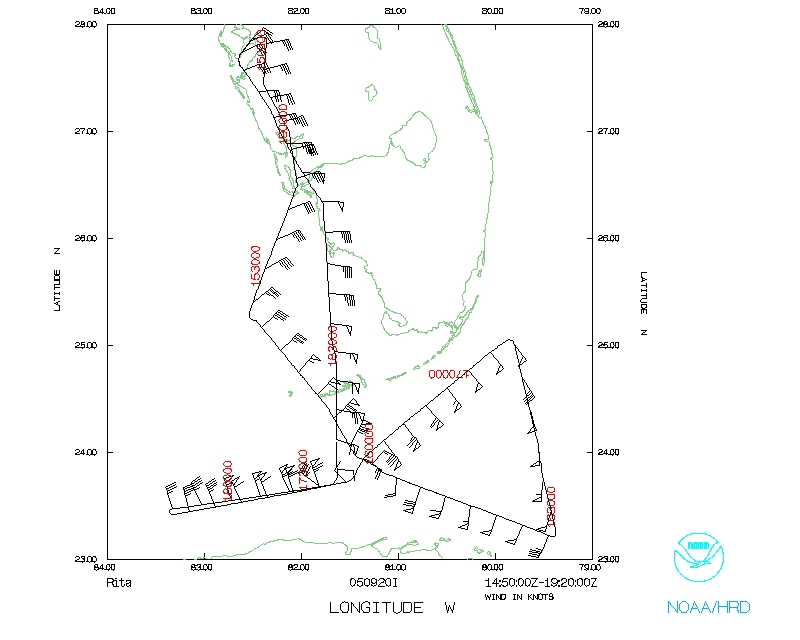
favorable environment for continued intensification.The NOAA P3 left
MacDill AFB,FL at 11:00 AM EDT. The pattern was flown as planned, with a
modification to account for the proximity of the storm to Cuba (Fig. 5).
During the flight the storm was getting better organized. The surface
wind maximum was 90 kt on the southeast side of the storm. There was a
marked asymmetry in SFMR-derived winds between the northwest and the
southeast side, as peak SFMR-derived winds on the northwest side were 65
kt and peak SFMR-derived winds on the southeast side were 90 kt. The
eyewall was open on the
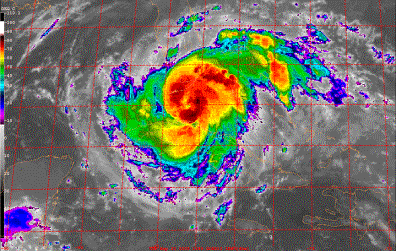
Figure 1. GOES-East infrared image valid 1245 UTC September 20.
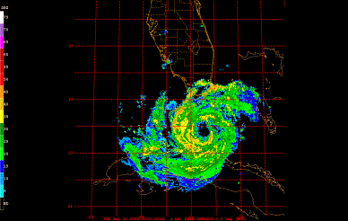
Figure 2. WSR-88D radar for Key West valid 1300 UTC September 20..
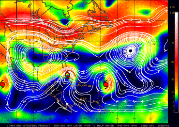
Figure 3. CIMSS-derived 250-850 hPa layer-averaged wind (shaded, kt) valid 09 UTC
September 20.
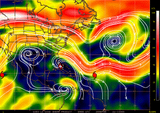
Figure 4. CIMSS-derived 850-200 hPa vertical shear (shaded, kt) valid 09 UTC
September 20.
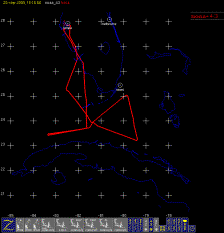
Figure 5. Plot of flight track for N43RF on September 20.
north side, as indicated by both lower fuselage and Key West 88D radar
(Fig. 6). The slope of the eyewall on the southeast side was nearly
vertical, while on the northwest side it was more horizontally-sloped.
The combination of the surface wind asymmetry, lower fuselage radar
pattern, and differences in the slopes of the southeast and northwest
eyewall all suggest the possibility that the storm is experiencing some
easterly or southeasterly shear. Also evident on the Key West radar is a
principal rainband spiraling in from the southeast, around to the north
side of the storm. The rain in the band is predominantly stratiform on
the north side of the storm but is mostly convective on the upwind side
of the band (i.e., east side of the storm). Multiple bands were also evident
on the southwest side of the storm. The initial pass through the storm
showed a double eyewall structure, with the outer eyewall open on the
north side and the inner eyewall open on the east and southeast side. On
subsequent passes the outer eye became more elliptical, rotating cyclonically
as the flight progressed. The MSLP dropped to 976 hPa, and the peak
surface winds (as observed by the SFMR) was 90 kt on the southeast side
of the storm. N43RF recovered at MacDill AFB, FL at 3:22 PM EDT.
A total of 6 HRD sondes was dropped, included one in each eyewall pass
and one at Key West. This was a successful mission, as it accomplished
the objectives of the tasking and sampled a storm that was complex and
highly-evolving. The presence of the principal rainband on the northeast
side and the multiple bands in the south are both possible targets for a
joint IFEX/RAINEX research mission planned for the following day.
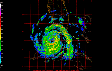
Figure 6. WSR-88D radar for Key West valid 2114 UTC September 20
Problems :
There were no significant problems on this mission. All 9 GPS sondes
worked well. SFMR compared favorably with drops and visually. There may
have been an initial 10-kt high bias, but the sonde on the southeast side
compared quite well with the SFMR. The cloud physics probes worked well.
Robert Rogers
9/30/05
Mission Data :
Ten second listing
Page last updated January 24, 2006
Return to Mission page.