Mission Summary
20101023I1 Aircraft 43RF
Air-Sea Mission Summary
Tropical Storm Richard
Aircraft Crew (43RF)
| Aircraft Commander | Al Girimonte |
| Co-pilot |
| Co-pilot | Mark Nelson |
| Flight Engineer | Greg Bast |
| Flight Engineer |
| Navigator |
| Flight Director | Barry Damiano |
| System Engineer |
| Data Technician | Bill Olney |
| Dropsonde Operator | Mike Mascaro |
Scientific Crew (43RF)
| Lead Scientist | Mike Black |
| Radar Scientist | Sim Aberson |
| Dropsonde Scientist | Tomislava Vukicevic |
Proposed track
|
Mission Plan :
This mission was planned to be one of several back-to-back missions into
Richard to study air-sea interaction and, possibly, rapid intensification.
The G-IV had flown a pattern around Richard and in the western Caribbean and
Se Gulf of Mexico earlier in the day. A 6-radial leg butterfly pattern with
100 nmi leg lengths was planned. Also, an extended leg, coming on from the
west was planned to drop AXBTS and sondes along the forecast track of Richard.
(Fig. 1). We would fly at 12,00 feet for most of the pattern. N43 would descend
to 5,00-0 ft for our last SE-NW pass through the center, deploying a sequence
of 12 AXBT/Dropsondes combos as a boundary layer flux module.
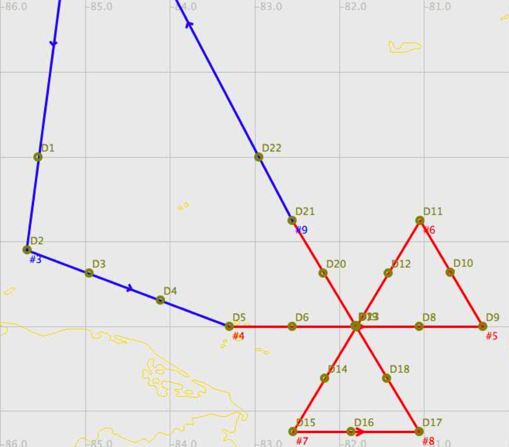
Fig. 1: Planned flight track into Richard. Combination AXBT/Dropsonde locations are indicated by circles.

Fig. 2: IR satellite imagery of TS Richard at 0215 UTC, 23 October 2010.
Richard was a minimum (35 kt) tropical storm (TS) prior to takeoff. It was
located about 150 miles from the SW tip of Honduras. Prior to takeoff, the IR
imagery look impressive, with active deep convection and not much apparent
shear (Fig. 2). Microwave imagery (Fig. 3) suggested that the center of Richard
was far enough off the Central America coast for N43 to operate in. Richard
was forecast to slowly intensify and to track to the WNW just north of Honduras
before making landfall in Belize or the Yucatan in a few days.
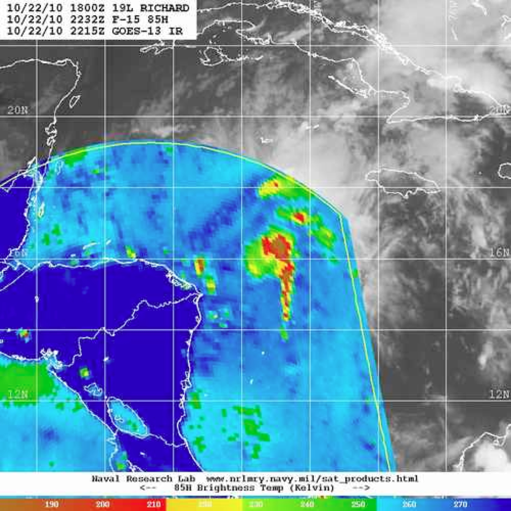
Fig. 3: SSMI microwave satellite imagery of TS Richard at 2215 UTC 22 October.
AIR-SEA MISSION PLAN: Richard
Prepared by: Hurricane Research Division
Aircraft: N43RF
Proposed takeoff: 23/2000Z
| DROP
| LAT
| LON
| UTC Time
| Local Time
|
| #
| (d m)
| (d m)
| (h m)
| (h m)
|
| 1 | 17°59' | -85°33' | 04:14 | 00:14
|
| 2 | 16°54' | -85°41' | 04:28 | 00:28
|
| 3 | 16°37' | -84°57' | 04:39 | 00:39
|
| 4 | 16°18' | -84°06' | 04:52 | 00:52
|
| 5 | 16°00' | -83°18' | 05:05 | 01:05
|
| 6 | 16°00' | -82°33' | 05:15 | 01:15
|
| 7 | 16°00' | -81°48' | 05:26 | 01:26
|
| 8 | 16°00' | -81°03' | 05:37 | 01:37
|
| 9 | 16°00' | -80°18' | 05:47 | 01:47
|
| 10 | 16°38' | -80°41' | 05:58 | 01:58
|
| 11 | 17°15' | -81°03' | 06:08 | 02:08
|
| 12 | 16°37' | -81°25' | 06:18 | 02:18
|
| 13 | 16°00' | -81°48' | 06:29 | 02:29
|
| 14 | 15°23' | -82°10' | 06:39 | 02:39
|
| 15 | 14°45' | -82°33' | 06:49 | 02:49
|
| 16 | 14°45' | -81°52' | 06:59 | 02:59
|
| 17 | 14°45' | -81°03' | 07:10 | 03:10
|
| 18 | 15°23' | -81°26' | 07:20 | 03:20
|
| 19 | 16°00' | -81°48' | 07:30 | 03:30
|
| 20 | 16°37' | -82°11' | 07:41 | 03:41
|
| 21 | 17°15' | -82°33' | 07:51 | 03:51
|
| 22 | 18°00' | -82°57' | 08:03 | 04:03
|
Mission Summary :
| Take off
| Landing
| MacDill AFB, FL
| 23/02:04 UTC
| MacDill AFB, FL
| 23/10:15 UTC
| |
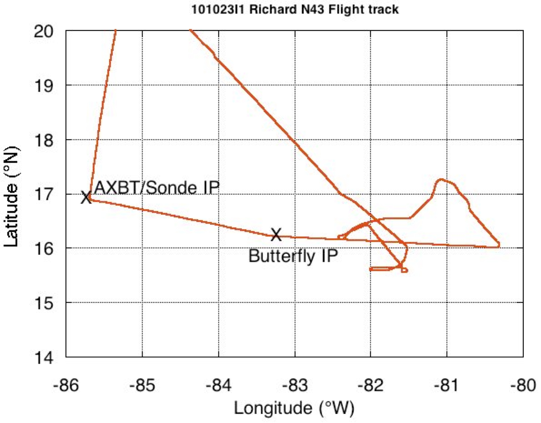
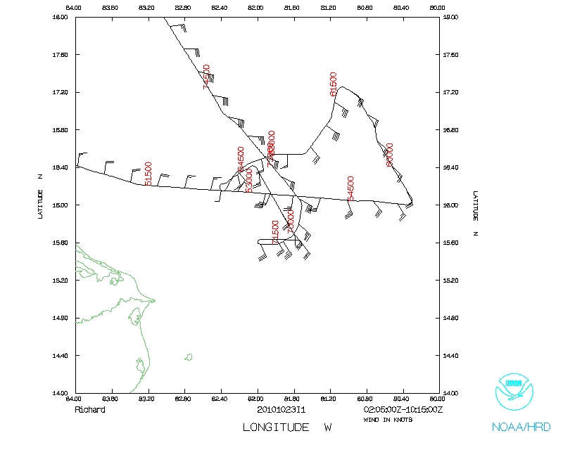
Fig. 4: Actual flight track into Richard.
Takeoff from San Jose was at 0205 UTC from MacDill and NOAA43 headed sooth for
the Initial Point (IP) . about 240 nmi WNW of the projected center of Richard.
N43 then headed east toward the center, releasing 4 AXBTs and dropsondes before
reaching the IP of the butterfly patter, 100 nmi west of Richard's center at
0513 UTC. Tracking to the east, the winds suggested that the center was further
west than anticipated but flight-level winds never indicated a well-defined
center. After passing to the east side of Richard, we encountered vigorous
convection with active lightning and the aircraft experienced large amounts of
graupel. At 0550 UTC, we decided to descend to 11,000 feet to reduce the
chances of flying through graupel again. We reached our East and NE points at
0554 and 0613 UTC, respectively and headed to the SW to try and find the
flight-level center. As we approached the anticipated center, the winds were
indicating that a possible center was to our south, very near the NE tip of
Honduras, in an area where we did not have clearance to fly. At that point, we
knew we had to abandon our planned butterfly pattern an we turned around to
the NW, then SE to try again to find a wind center. We did not. Finally, we
descended to 5,000 ft in the hope that a low-level center might be more well
defined there and, if we could locate a center, to try the AXBT/Sonde sequence
from near the RMW to the center. From a point about 60 miles east of the
center, we attempted to track toward the center but realized that it was to
close to the coast to fly and a very vigorous MCS was just outside of our
no-fly zone and we could not maneuver safely around it. We turned around to
the east, away form the MCs and made a final run from the SE to the NW,
releasing our final AXBT/Sonde combos along the way. Figure 4 shows the actual
flight track the N43 completed.
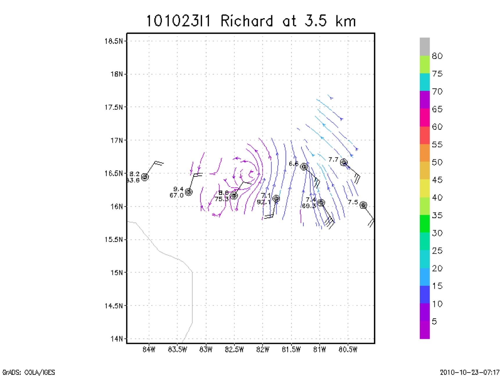
Fig. 5: Doppler wind analysis with dropsonde observation at 3.5 km for the west
to East .
A real-time Doppler wind-analyses showed that Richard had a well-defined
mid-upper level center (Fig. 5). This was in good agreement with the IR
satellite image of Richard (Fig 6) that showed the main areas of convection
still offshore. We headed back around the western tip of Cuba and landed back
at Macdill at 1010 UTC.
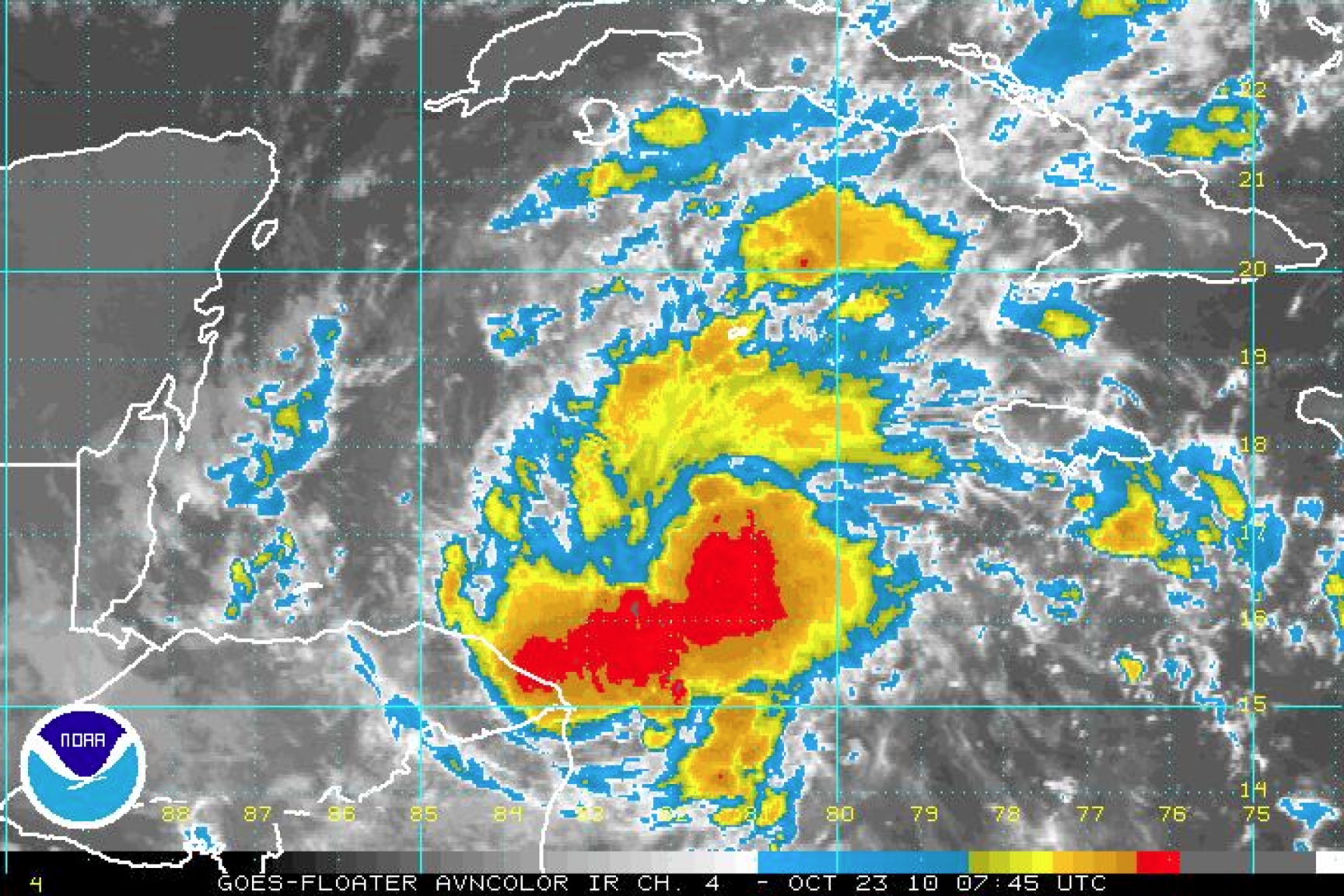
Fig. 6: IR satellite imagery of TS Richard at 0745 UTC, 23 October 2010.
Problems :
Equipment and Expendables: A total of 18 AXBTs were deployed and all worked
well. Of the 19 GPS sondes that were released, one failed. Three Doppler wind
analyses were performed. The radar and flight-level systems performed well
with only the radar system freezing up for very brief periods 3 times.
Michael Black
10/27/10
Mission Data :
LPS forms |
Radar forms |
Dropsonde forms
Serial data |
1 Second data |
NetCDF data
Page last updated June 21, 2011
Return to Mission page.