Mission Summary
20081108N1 Aircraft 49RF
Paloma Rapid Intensity flight 2008
| Aircraft Commander | Odell |
| Flight Director | Jackie Almieda |
| LPS/Dropsonde Scientist | John Kaplan |
| Aircraft Commander | Odell |
| Flight Director | Jackie Almieda |
| LPS/Dropsonde Scientist | John Kaplan |
Mission Plan :
This G-IV research mission was a follow-up to the one conducted 24 h earlier with the flight plan designed to obtain symmetric data coverage within 2-4° radius of Paloma's center.
Mission Summary :
The G-IV jet left MacDill AFB, FL at 02:00 UTC. The flight plan was executed as designed although the end points of the legs were shortened somewhat since the planes autopilot did not allow the turns to be as sharp as those that were planned. Consequently, the drop locations (see below) were about 10 miles or so closer to the storm center than originally planned.
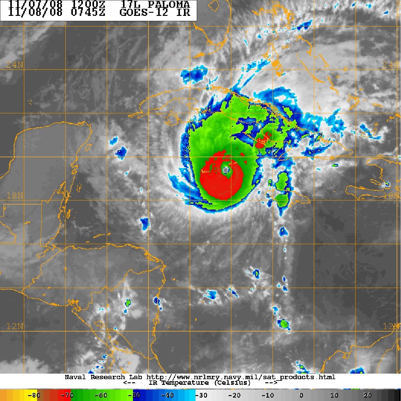
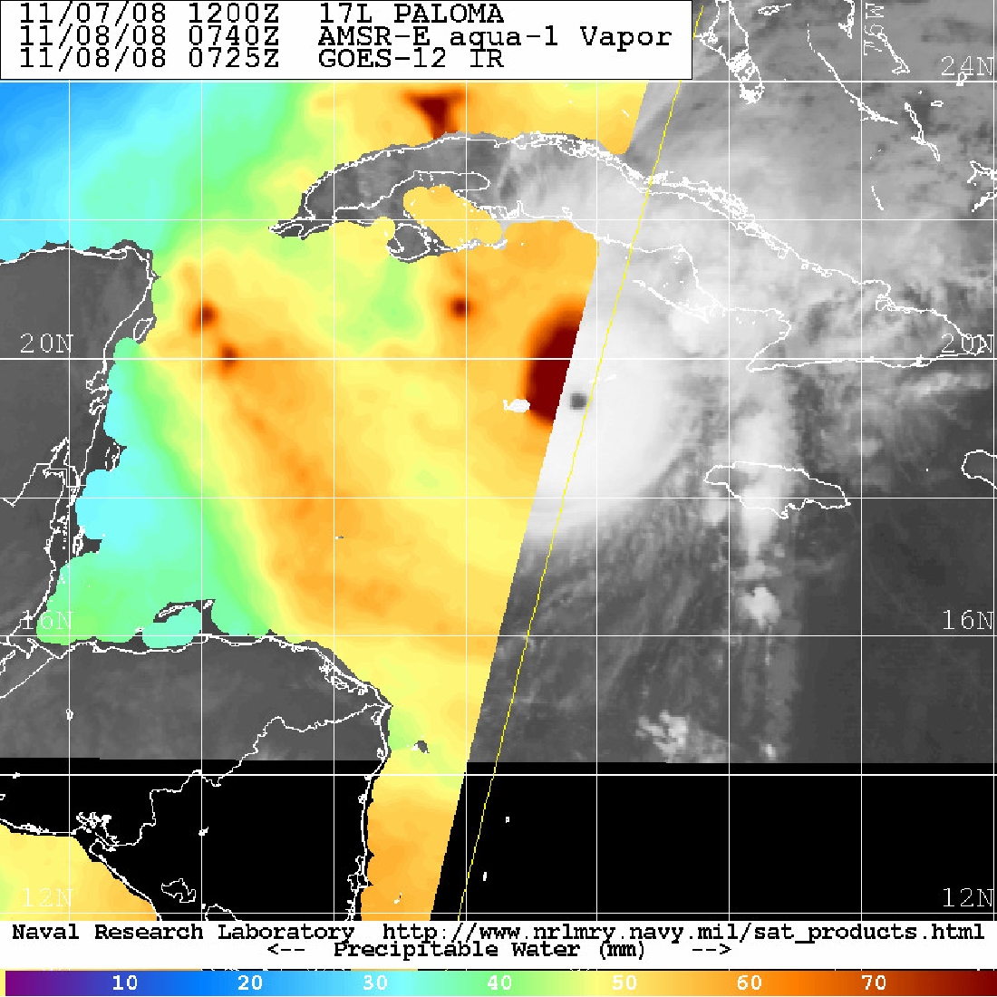
Paloma had intensified rapidly to become a Category 3 Hurricane with 105 kt sustained winds and a central pressure of about 958 mb by the nominal time (0600 UTC 8 November) of the G-IV mission. The GOES satellite imagery at around this time (Fig 1) shows that Paloma had now developed a well defined eye and had become more symmetric since the G-IV flight 24-h ago. The mid-level dry air observed during the proceeding flight does not appear to have been getting quite as close to the center of Paloma particularly at 700 mb. However the water-vapor imagery for this time period (Fig. 2) indicates that there is some dry air located well to the northwest of the center. It is possible that this dry air may have contributed to the weakening that was observed just prior to Paloma's landfall over Cuba late in the afternoon on the 8th.
The 200 mb G-IV data indicate that there was pretty good outflow to the north and east of Paloma but not necessarily to the west. The SHIPS analyzed divergence at this time was about 71 X10-7s-1 which is nearly the same as the previous day. Although the SHIPS 200-850 mb shear of 17 kt was nearly twice as high as it was during the previous flight it is not clear if shear of this magnitude was actually affecting the inner-core region since the SHIPS shear is evaluated within 500 km radius of the center. In any event, Paloma continued to intensify rapidly throughout the early afternoon becoming a category 4 Hurricane with maximum winds of 125 kt and a minimum central pressure of about 950 mb. This made Paloma the second strongest Atlantic basin November Hurricane on record. The G-IV jet recovered at MacDill AFB, FL by 11:00 UTC.
b>Problems :
The sondes worked fairly well although there were 3 fast fall sondes that had to be backed up bringing the total number of sondes dropped to 27 with 24 being transmitted. Another sonde had late winds but this was worked up and transmitted.
John Kaplan
Dec. 12, 2008
|
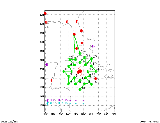
Aircraft: N49RF Altitude: FL410-450 Takeoff: 08/0200Z | ||||
| DROP # | LAT (d m) | LON (d m) | PROPOSED TIME (h mm) | COMMENTS |
| 1 | 22 06 | 82 04 | 0:48 | Fast fall/ Not sent |
| 1a | 22 06 | 82 18 | 0:50 | |
| 2 | 22 00 | 83 36 | 1:01 | |
| 3 | 20 55 | 82 24 | 1:16 | |
| 4 | 20 38 | 83 51 | 1:28 | |
| 5 | 20 00 | 83 24 | 1:40 | |
| 6 | 19 30 | 85 08 | 1:57 | Fast fall/Not sent |
| 6a | 19 12 | 84 48 | 1:59 | |
| 7 | 18 18 | 83 48 | 2:12 | |
| 8 | 16 41 | 83 53 | 2:27 | Fast fall/Not sent |
| 8a | 16 54 | 83 36 | 2:29 | |
| 9 | 18 00 | 82 24 | 2:44 | |
| 10 | 16 48 | 82 00 | 2:56 | |
| 11 | 17 24 | 81 00 | 3:09 | |
| 12 | 15 42 | 80 48 | 3:26 | |
| 13 | 16 42 | 79 36 | 3:41 | |
| 14 | 16 48 | 78 06 | 3:56 | |
| 15 | 18 05 | 79 18 | 4:13 | |
| 16 | 18 36 | 78 24 | 4:23 | |
| 17 | 19 30 | 78 36 | 4:33 | |
| 18 | 19 36 | 76 48 | 4:50 | |
| 19 | 20 30 | 77 48 | 5:05 | |
| 20 | 22 24 | 77 54 | 5:20 | |
| 21 | 21 00 | 79 24 | 5:37 | |
| 22 | 21 36 | 80 48 | 5:52 | drop location slightly shifted |
| 23 | 22 30 | 79 54 | 6:06 | drop location slightly shifted |
| 24 | 23 30 | 80 54 | 6:24 | |