Mission Summary
20081107I1 Aircraft 43RF
Paloma Rapid Intensity flight 2008
Scientific Crew (43RF)
| Lead Project Scientist | Eric Uhlhorn |
| Radar Scientist | Shirley Murillo |
| Doppler Scientist | Neal Dorst |
Flight Crew (43RF)
| Pilots | Barry Choy
Amelia Ebhardt
Sweeny
|
| Flight Director | Paul Flaherty |
| Navigator | Tim Gallagher |
| Flt. Eng. | P. Floyd |
| Data Tech | Terry Lynch
Joe Green |
| Elec. Tech | Daemon San Souci |
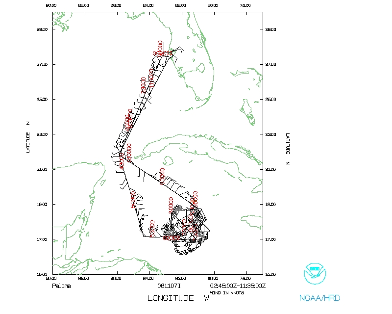
Figure 1. 20081107I1 Flight track.
Mission Plan :
N43RF will fly a rapid-intensification experiment in TS Paloma. It will leave
MacDill AFB, FL at 02:00 UTC, and recover at MacDill AFB, FL by 11:00 UTC.
Flight altitude will be 12000'.
Drop Plan
Paloma
Prepared by the Hurricane Research Division
Aircraft: N43RF
Altitude: FL180-250
Proposed takeoff: 07/0200Z
|
DROP
#
| LAT
(d m)
| LON
(d m)
| RAD/AZM
(nm/dg)
| LEG
(nm)
| TOTAL
(nm)
| TIME
(h mm)
|
| MACDILL | | 0. | 0. | 0:00
|
| 1 | 22 00 | 85 06 | | 379. | 379. | 1:25
|
| 2S | 16 36 | 84 12 | 75/270 | 329. | 707. | 2:48
|
| 3S | 16 36 | 81 36 | 75/090 | 150. | 857. | 3:26
|
| 4S | 17 51 | 82 54 | 75/000 | 106. | 963. | 3:53
|
| 5S | 15 21 | 82 54 | 75/180 | 150. | 1113. | 4:31
|
| 6S | 15 43 | 81 59 | 75/135 | 57. | 1170. | 4:46
|
| 7S | 17 29 | 83 49 | 75/315 | 150. | 1320. | 5:25
|
| 8S | 15 43 | 83 49 | 75/225 | 106. | 1427. | 5:52
|
| 9S | 17 29 | 81 59 | 75/045 | 150. | 1577. | 6:30
|
| 10 | 22 00 | 85 06 | | 324. | 1900. | 7:43
|
| MACDILL | | 379. | 2279. | 9:01
|
Mission Summary :
| Take off
| Landing
| MacDill AFB, FL | 02:45 UTC
| MacDill AFB, FL | 11:50 UTC
| |
The flight plan consisted of a rotated figure-4 to obtain 4 Doppler wind
analyses. N43RF departed KMCF at 0245 UTC after a small delay due to an AVAPS
hardware glitch. Cuban airspace clearance was not obtained, somewhat increasing
the ferry time to the IP, which was reached at 0522 UTC 105 nmi to W of storm.
The MSLP for Leg #1 was found to be 993 mb (although likely displaced from the
center), and a peak surface wind of 68 kts from GPS was found in the E eyewall,
indicating Paloma was very near hurricane intensity. Leg #1 was completed at
0613 UTC, and N43RF turned to NW heading to a point N of center. Leg #2 began
at 0637 UTC heading S, passing through the center (MSLP 984 mb), and ending at
0714 UTC next turning to NE. Leg #3 started to SE of storm heading NW at 0726
UTC. Leg #3 ended at 0803 UTC, with the center GPS drop failing to measure the
MSLP. Leg #4 was begun at 0821 UTC SW of the storm heading NE for a final pass
through the storm (MSLP 982 mb) and terminated at 0901 UTC to the NE of the
center. N43RF returned to KMCF at 1150 UTC.
Four Doppler wind analyses were produced and transmitted off the plane.

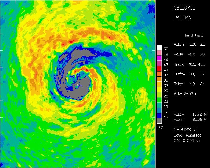
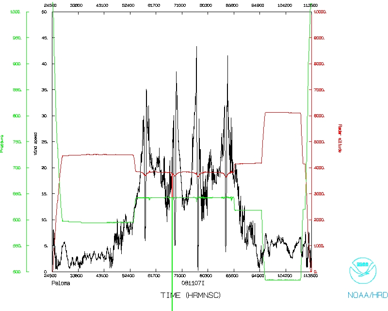
Figure 2. LF radar reflectivity at beginning (0554 UTC) and end (0839
UTC) of flight.
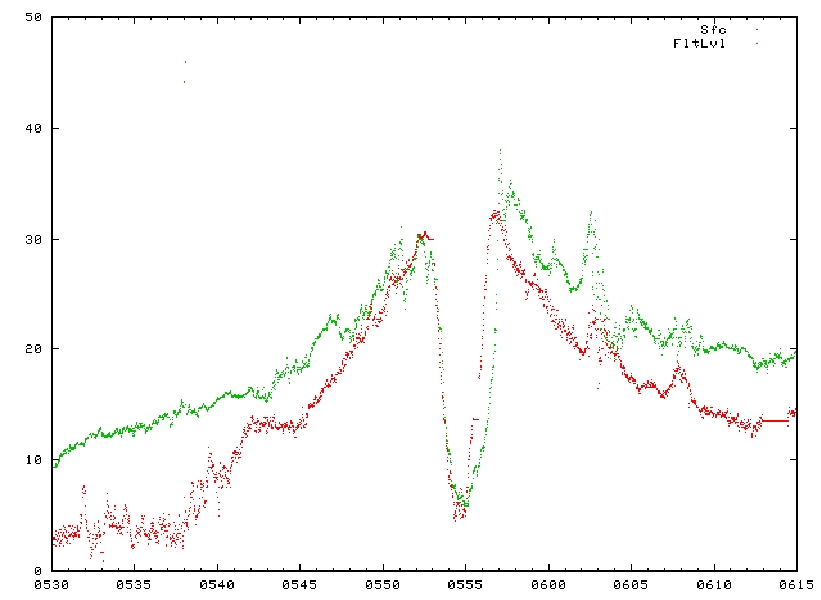
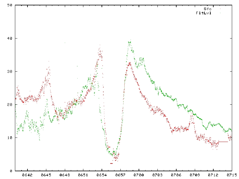
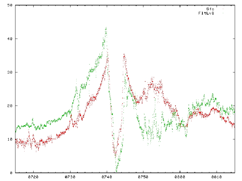
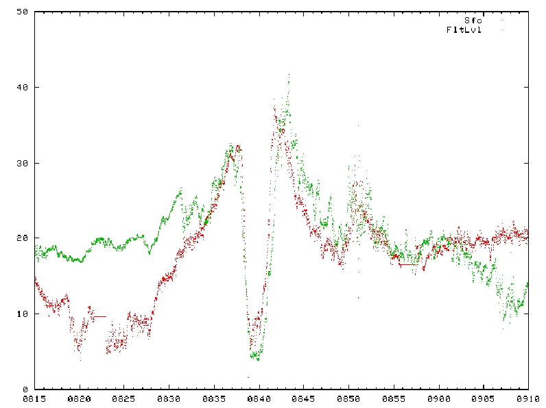
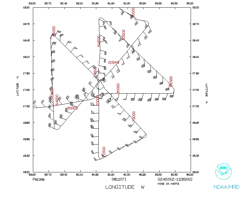
Figure 3. SFMR surface and flight level wind speeds for the four passes.
Summary of Expendables
| GPS dropwindsondes
| 23
|
| AXBTs
| 14/16
|
Problems :
The original plan called for 32 GPS sondes to be released, with somewhat high
density during each eyewall pentration. The AVAPS hardware problem limited
this capability, and as a result, only 23 were ultimately deployed.
EWU
24 April 2009
Mission Data :
Dropsonde plots
700 mb
850 mb
925 mb
1000 mb
surface
One second listing
NetCDF listing
Page last updated April 27, 2009
Return to Mission page.