 Proposed flight track |
 Final flight track |
| Aircraft Commander | Scott Price |
| Co-pilot | Pat Didier |
| Co-pilot | Danny Rees |
| Navigator | Pete Seigel |
| Flight Engineer | Paul Darby |
| Flight Engineer | Ken Heystek |
| Flight Director | Ian Sears |
| Data Technician | Terry Lynch |
| Data Technician | Dale Carpenter |
| Dropsonde Operator | Mike Mascaro |
| Dropsonde Operator | Todd Richards |
| LPS | Frank Marks | HRD |
| Radar | Hui Christophersen | HRD |
| Dropsondes | Ghassan Alaka | HRD |
| Observer | Joe Sapp | UMass |
| Observer | Jim Brewer | UMass |
| Observer | Mike Perez | UMass |
| Guest | Alex Desrosier | AOC intern |
| Media | Bucky McMahon | freelance |
| Radar | John Gamache | HRD |
Mission Plan :
|
Proposed flight track |
Final flight track |
Mission priority was to provide tail Doppler radar (TDR) observations for initializing the operational HWRF (see Proposed flight track). If possible we also wished to accomplish:
|
Prepared by Hurricane Research Division Prepared by the Hurricane Research Division File: current1.ftk October 08, 2016 10:00:00 AM Aircraft: N43RF Proposed takeoff: 7/0600Z | |||||||
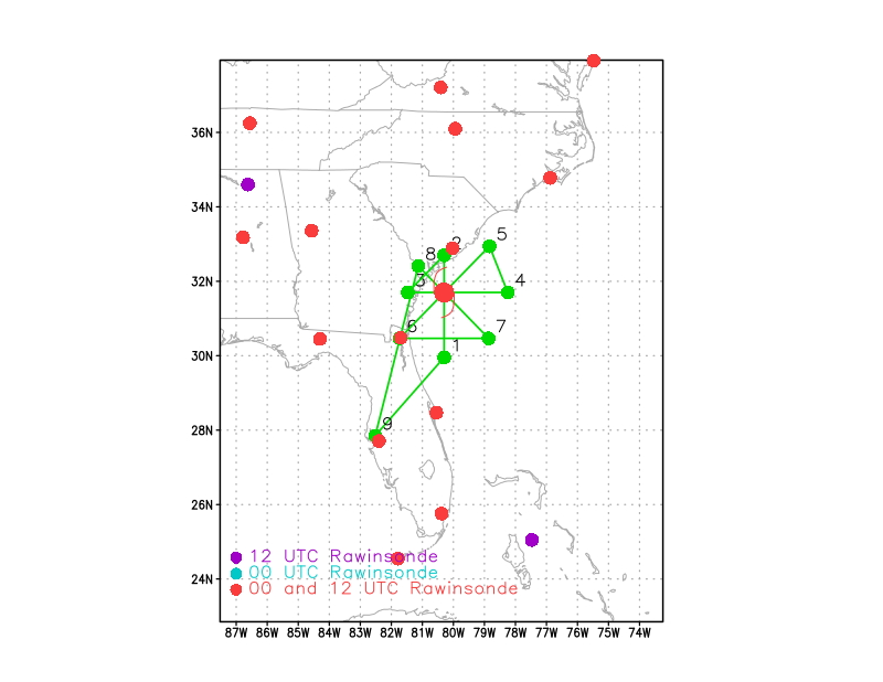
| DROP LOCATION TABLE | |||||||
| # | LAT | LON | RAD/AZM | Time | |||
| deg min | deg min | n mi/deg | hr:min | ||||
| 1S | 29 57 | 80 18 | 105/180 | 1:32 | |||
| 2S | 32 42 | 80 18 | 60/000 | 2:16 | |||
| 3S | 31 42 | 81 28 | 60/270 | 2:40 | |||
| 4S | 31 42 | 78 15 | 105/090 | 3:24 | |||
| 5S | 32 57 | 78 50 | 105/045 | 3:46 | |||
| 6S | 30 28 | 81 44 | 105/225 | 4:43 | |||
| 7S | 30 28 | 78 52 | 105/135 | 5:23 | |||
| 8S | 32 25 | 81 08 | 60/315 | 6:07 | |||
| Take off | Landing
| MacDill AFB, FL
| 05:55 UTC
| MacDill AFB, FL
| 13:15 UTC
| | ||
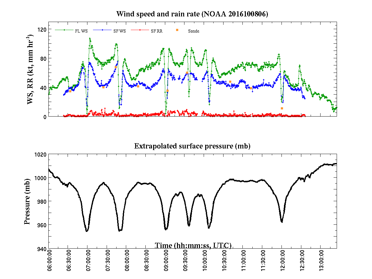
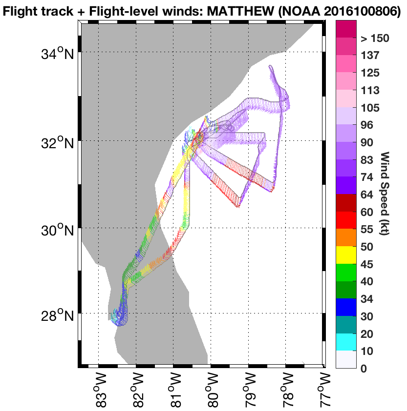
Hurricane Matthew's north eyewall was onshore near Hilton Head, SC when we arrived necessitating a change in planned flight track. We abandoned attempting to pass to the north and northwest of the center removing points 2, 3, and 8 from the pattern. We flew from the IP to the center and then to point 5 measuring flight level winds exceeding 100 kts just northeast of the center. We then attempted a coastal survey from point 5 to just west of the center turning very close to Savannah passing through 95+ kt flight level winds in the NE portion of the eyewall, just offshore. We then proceeded to point 7, downwind to point 4 and back into the center to complete the first TDR survey for HWRF initialization. Then we performed to IWRAP legs back and forth to the northeast of the center through the radius of maximum winds. Unfortunately, by this time the peak winds had decreased below 90 kts once the north eyewall moved over the shoreline, likely as a result of increased friction overland. During the two legs we observed a large convective blow up in the north eyewall as it passed over Charleston, SC, effectively accomplishing a very interesting convective burst module over the 45 minutes it took to finish the IWRAP legs.
Having noticed that hurricane force winds extended well to the east of the center we flew a 120 nm leg east southeast of the center and then proceeded to go downwind attempting to intercept intense convective rainbands seen on the WSR-88D network radar hitting the coast between Myrtle Beach, SC and Wilmington , NC. We were able to sample two very intense convective bands with large low-level helicity just east of Myrtle Beach with the TDR and we deployed a dropsonde to acquire thermodynamic information of this convective environment (CAPE). Following that we proceeded back to the center and outbound to the south southwest to complete the last TDR mapping for HWRF initialization (see Final flight track below)
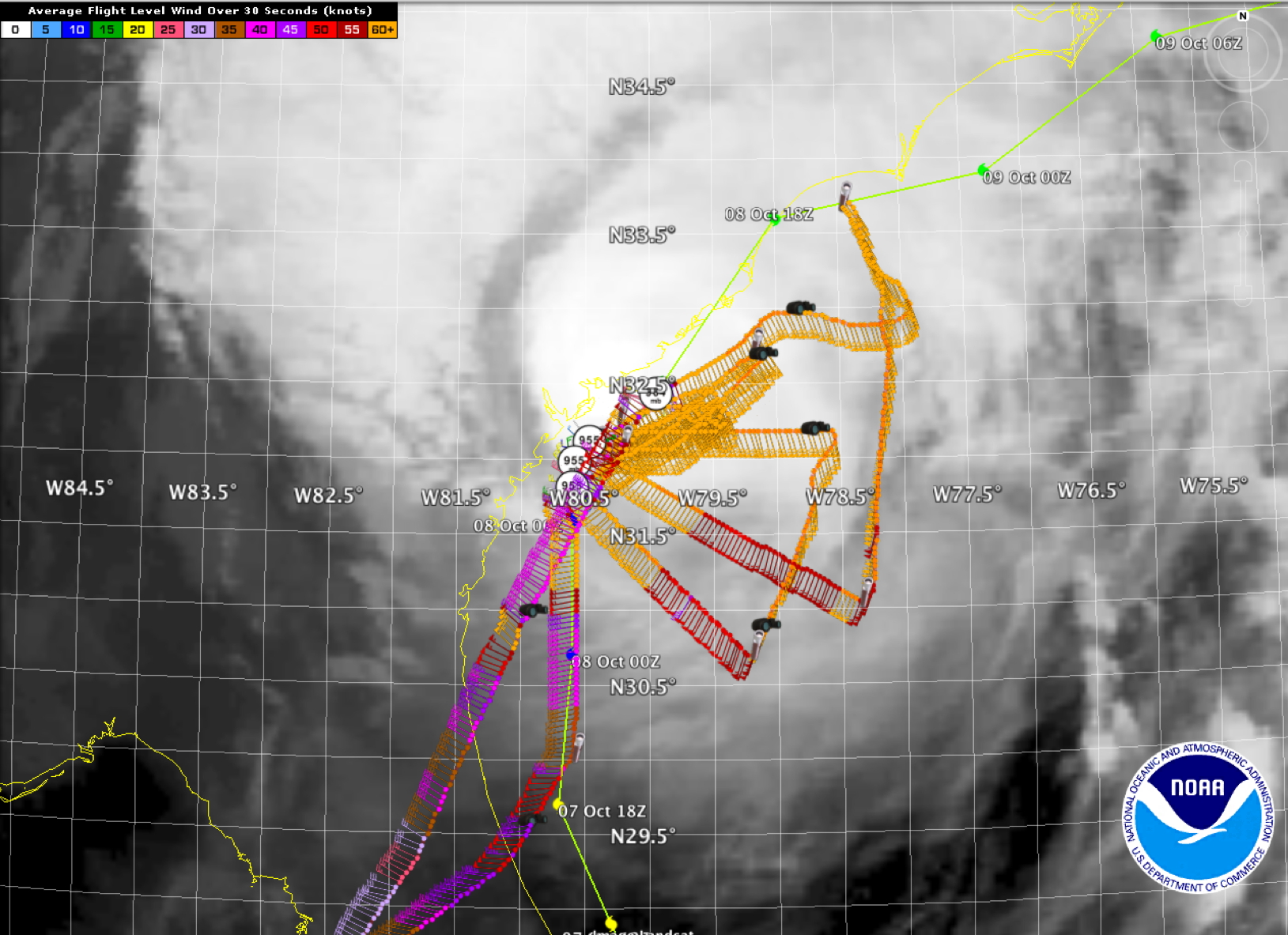 Final flight track |
Evaluation:
The mission was extremely successful given the proximity of the storm to the coast. We were able to accomplish all the objectives we set out to do, and managed to serendipitously get a convective burst module in a convective even as the north eyewall moved ashore near Charleston, SC.
Problems :
AOC repaired the TDR motor which burned out during the previous mission and we had zero problems with it. Fantastic work by Dana Naeher and Bobbie Peak staying after their mission to insure we were ready to go with the primary objective.
Only problem was an early launch detect on one dropsonde.
| GPS sondes | 10 |
| AXBTs | 0 |
| Sonobuoys | 0 |
| Doppler analyses completed | 4 |
|
Final flight track |
||
Plot of raw High Density Obs |
Plot of raw Flight Level winds |
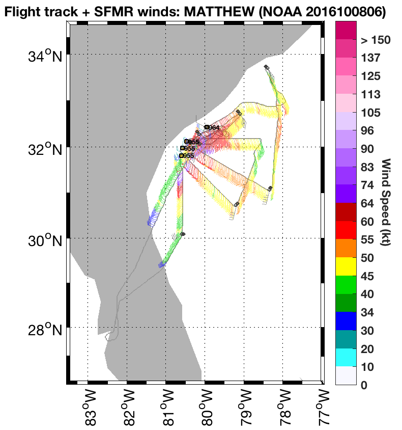
Plot of raw SFMR winds |
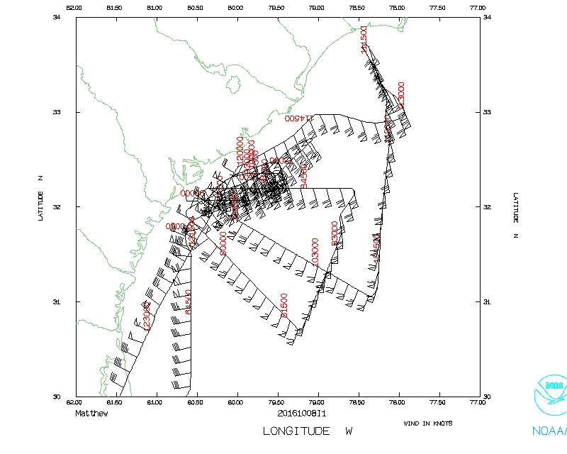 Flight track |
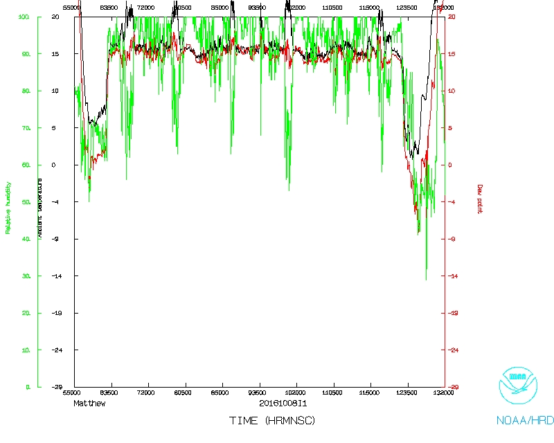 Temperature and Moisture |
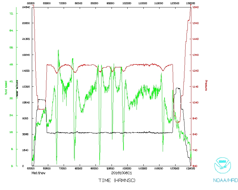 Wind and Atlitude |
LPS's log | Radar Scientist's log | Dropsonde Scientist's log
Flight Director's log |
Flight Director's manifest |
NetCDF data |
1 second data |
SFMR data