Proposed flight track for 20170922H1 |

Detail of proposed flight track for 20170922H1 |
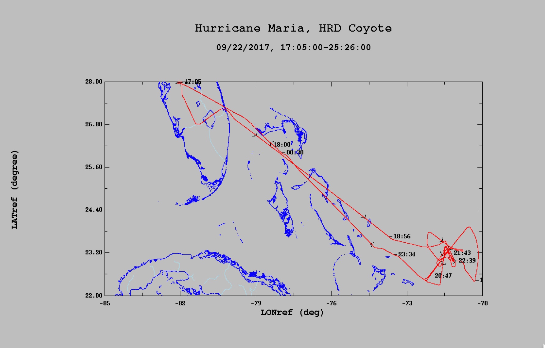
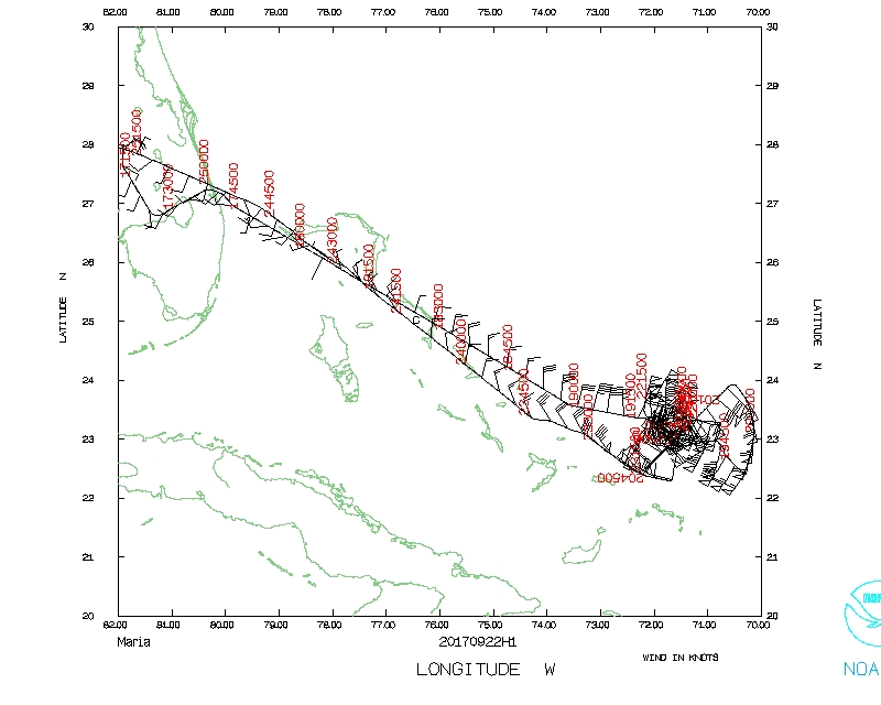
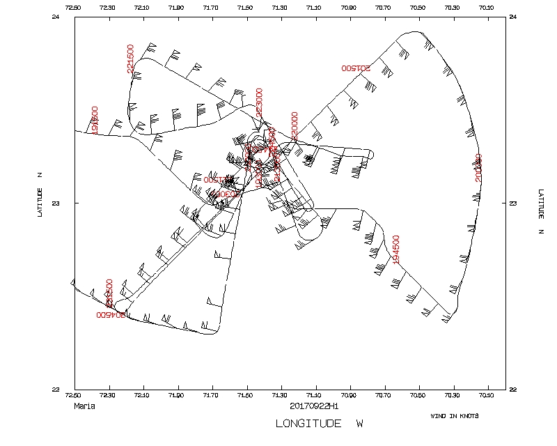
Final flight track for 20170922H1 |
| Aircraft Commander | Justin Kibbey |
| Co-pilot | Kahn |
| Co-pilot | Dider |
| Co-pilot | Mitchell |
| Flight Engineer | Ken Heystek |
| Flight Engineer | Mike Sanchez |
| Navigator | Freeman |
| Flight Director | Jess Williams |
| System Engineer | Paul |
| Data Technician | Marc Marasco |
| Dropsonde Operator | McAllister |
| Lead Project Scientist | Joe Cione | HRD |
| Radar Scientist | Jun Zhang | HRD |
| DWL Scientist | Kelly Ryan | HRD |
| COYOTE | Brad Kent | Raytheon |
| Guest | Steve Kennan | U.S. Senate aide |
| Guest | Chris Oliver | NMFS |
| Radar Scientist | John Gamache | HRD |
Mission Plan :
NOAA 42RF (N42) will perform an HRD-tasked Doppler Winds LIDAR and COYOTE mission into Hurricane Maria. Takeoff from Lakeland is at 1700Z. Following the Figure-4 vortex survey, aircraft will turn inbound and release the Coyote UAS in the eye. Aircraft will then circumnavigate with repeated penetrations into and out of the eyewall, maintaining close communications with the Coyote UAS as the Coyote spirals outward into the eyewall. N42 flight altitude 10,000ft. Pattern may be updated for center position at time of mission. To the extent possible, keep straight legs heading to center during the initial Figure-4, as TDR data will be transmitted to EMC in real time.
Plan is for a 9-h duration mission.
Expendables: 12 IR sondes, 5 regular sondes, and 12 AXBTs.
|
Proposed flight track for 20170922H1 |
Detail of proposed flight track for 20170922H1 |
Final flight track for 20170922H1 |
|
Prepared by the Hurricane Research Division September 21, 2017 Aircraft: N42RF Proposed takeoff: 22/1800Z
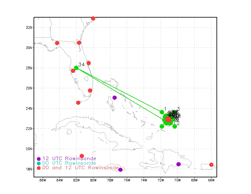
DROP LOCATION TABLE
| #
| LAT
| LON
| RAD/AZM
| Time
|
| deg min
| deg min
| n mi/deg
| hr:min
| 1S | 23 37 | 71 52 | 60/315 | 1:53
| 2S | 22 12 | 70 20 | 60/135 | 2:23
| 3S | 23 37 | 70 20 | 60/045 | 2:46
| 4S | 22 12 | 71 52 | 60/225 | 3:16
| 5S | 22 47 | 71 14 | 10/225 | 3:30
| 6S | 22 40 | 71 21 | 20/225 | 3:33
| 7S | 22 38 | 71 24 | 23/225 | 3:35
| 8S | 22 36 | 71 26 | 25/225 | 3:37
| 9S | 22 30 | 71 18 | 25/205 | 3:40
| 10S | 22 41 | 71 12 | 14/205 | 3:44
| 11S | 22 41 | 71 01 | 14/160 | 3:48
| 12S | 22 35 | 70 59 | 20/160 | 3:50
| 13S | 22 30 | 70 56 | 25/160 | 3:53
| 14S | 22 34 | 70 48 | 25/140 | 3:56
| 15S | 22 43 | 70 56 | 14/140 | 4:00
| 16S | 22 53 | 70 51 | 14/095 | 4:03
| 17S | 22 52 | 70 44 | 20/095 | 4:06
| 18S | 22 52 | 70 38 | 25/095 | 4:08
| 19S | 23 01 | 70 39 | 25/075 | 4:12
| 20S | 22 58 | 70 51 | 14/075 | 4:16
| 21S | 23 06 | 70 58 | 14/030 | 4:19
| 22S | 23 11 | 70 55 | 20/030 | 4:22
| 23S | 23 17 | 70 52 | 25/030 | 4:24
| 24S | 23 20 | 71 01 | 25/010 | 4:27
| 25S | 23 08 | 71 03 | 14/010 | 4:31
| 26S | 23 05 | 71 15 | 14/325 | 4:35
| 27S | 23 10 | 71 18 | 20/325 | 4:38
| 28S | 23 15 | 71 22 | 25/325 | 4:40
| 29S | 23 09 | 71 29 | 25/305 | 4:43
| 30S | 23 02 | 71 18 | 14/305 | 4:47
| 31S | 22 52 | 71 21 | 14/260 | 4:51
| 32S | 22 51 | 71 27 | 20/260 | 4:53
| 33S | 22 49 | 71 34 | 25/260 | 4:56
| | ||||||||||||||
Mission Summary :
| Take off | Landing
| Linder-Lakeland, FL
| 17:05 UTC
| Linder-Lakeland, FL
| 01:24 UTC
| Penetrations
| 8
| | ||||
Expendables:10 dropsondes (9 IR), all good, 8 AXBTs, 7 good, 1 COYOTE, good.
Mission Evaluation:
Problems :
| NetCDF SFMR data | |
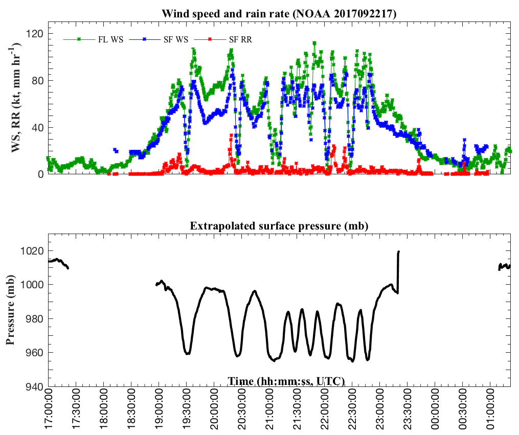
Timeseries wind, rain rate, and pressure plots |
|
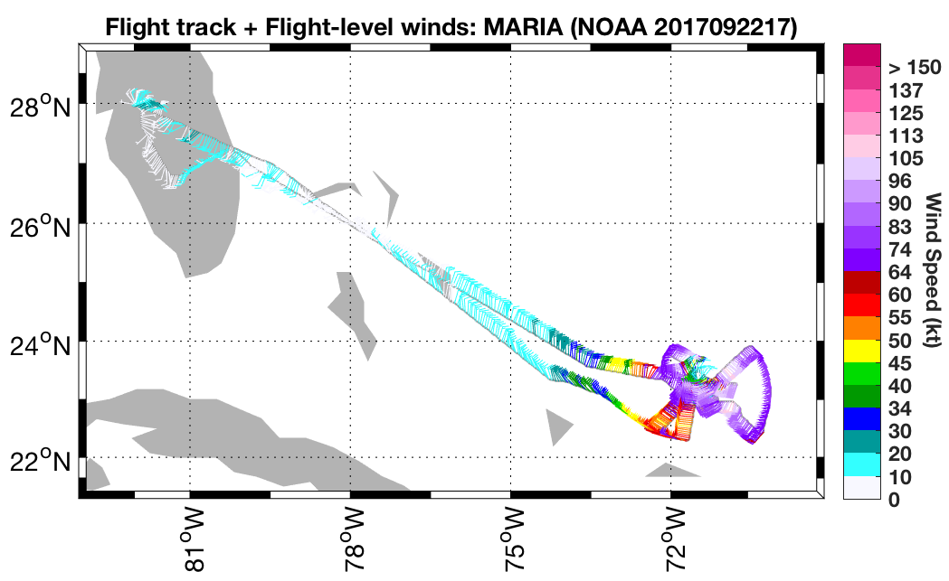
Flight level wind plots full flight |
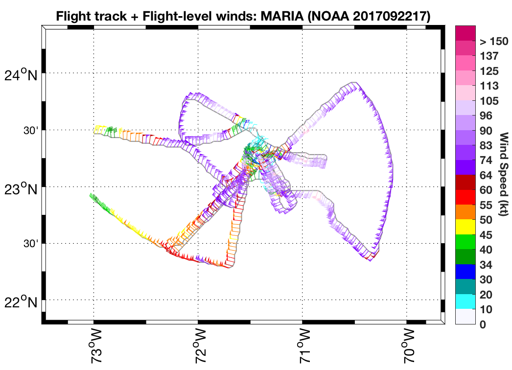
Flight level wind plots in storm |
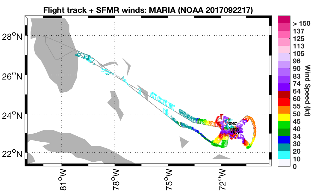
SFMR wind plots full flight |
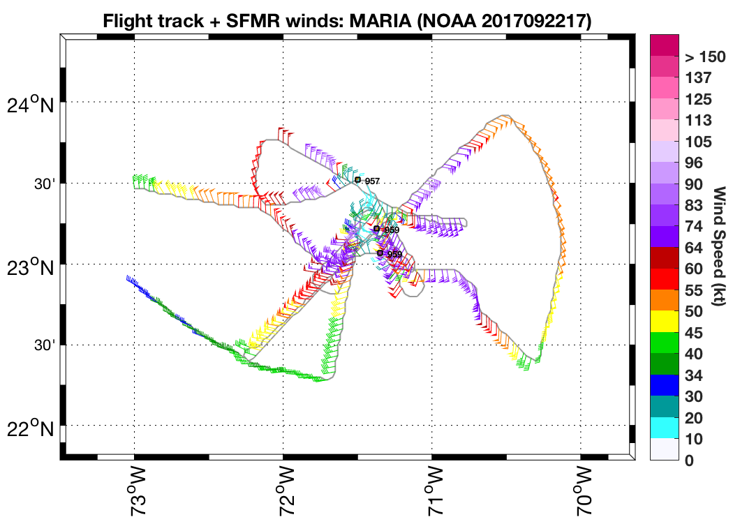
SFMR wind plots in storm |
 Flight track |
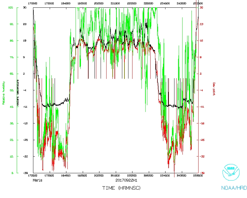 Temperature and Moisture |
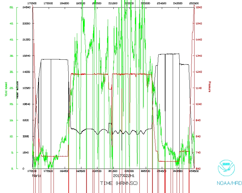 Wind and Atlitude |
 Flight track detail |
LPS log |
Radar log |
DWL log |
Drop log
Flight Director's log |
Flight Director's manifest |
SFMR data |
NetCDF data |
serial data |
1 second data