Mission Summary
20021003I Aircraft 43RF
Landfall/CBLAST in-storm mission into of Hurricane Lili
Click here for PDF version
Scientific Crew
| Lead scientist | Pete Black |
| Workstation scientist | Mike Black |
| Radar scientist | John Gamache |
| Sonde scientists | Sim Aberson |
| SRA scientist | Ed Walsh (NASA) |
| Laser Altimeter scientist | Joel Hazard (Scripps) |
| Guest scientist | Chris Cappella |
|
Aircraft Crew (43RF)
| Pilots | CAPT Dave Tennesen
CDR Phil Kenul
LCDR Harris Halverson |
| Navigator | LCDR John Adler |
| Flight Director | Barry Damiano |
| Engineer | Jeff Smith |
| Data Technican | Ray Tong |
| Electronics Technican | Damon San Souci |
|
Mission Briefing :
After HAIRSIN and Ocean Winds flights into Hurricane Lili, HRD
planned for a flight during Lili's landfall on the Louisiana
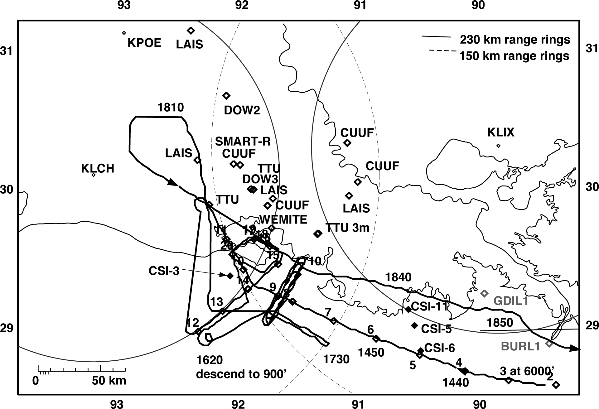
coast. Mobile observing teams from Texas Tech University (TTU),
Clemson, and the University of Florida were heading for the
Lousiana coast to deploy the SMART-R radar and several wind
towers. They were joined late in the evening of 2 October by two
portable Doppler radars from Univ. of Oklahoma, DOW-2 and DOW-3.
The HIRT team from North Carolina alwo drove an instrumented
vehicle to the region south of New Iberia, Louisiana.
Mission Synopsis :
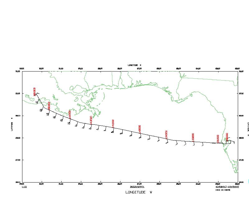
 NOAA 43 left MacDill Air Force Base at 1302 UTC, and descended to
6,000' at the IP ~200 km SSE of New Orleans at 1420. For the next
two hours the plane sampled the storm environment just along the
coast, dropping 20 GPS sondes along the coast and near the wind
towers, especially the WEMITE tower on West Cote Blanche Island.
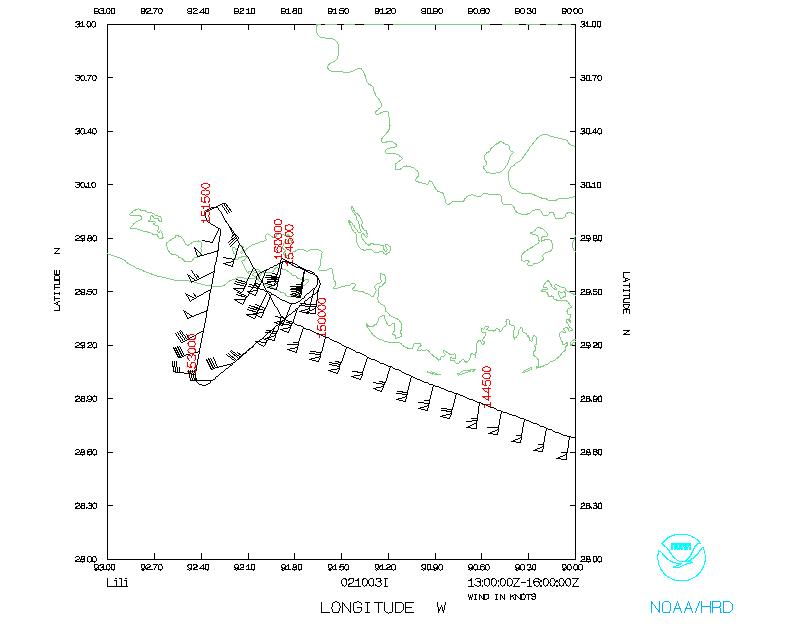
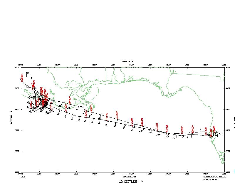
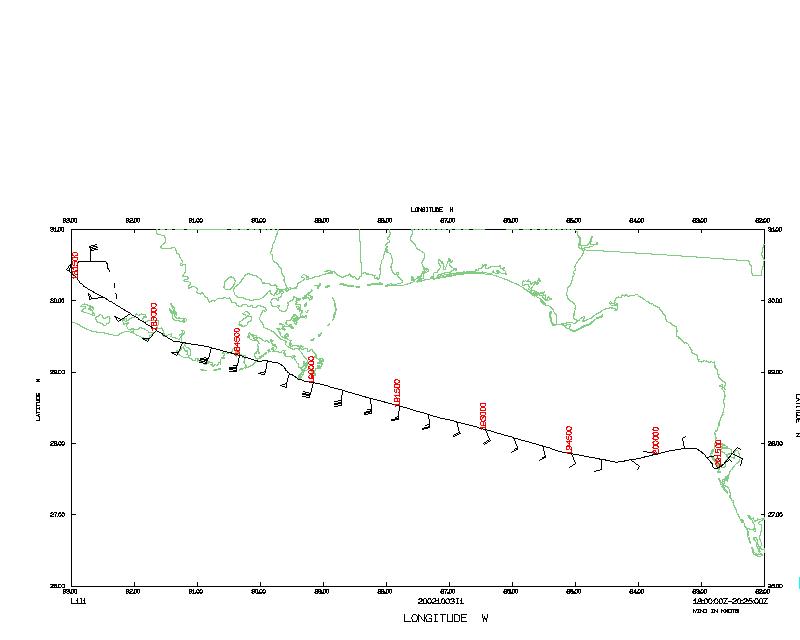
Figure 1 shows the complete flight
track, with sonde launch locations and portable observing sites.
NOAA 43 left MacDill Air Force Base at 1302 UTC, and descended to
6,000' at the IP ~200 km SSE of New Orleans at 1420. For the next
two hours the plane sampled the storm environment just along the
coast, dropping 20 GPS sondes along the coast and near the wind
towers, especially the WEMITE tower on West Cote Blanche Island.
Figure 1 shows the complete flight
track, with sonde launch locations and portable observing sites.
 Figure 2a is an LF radar image
from NOAA 43's initial pass through the center of Lili.
The CBLAST module began at 1623 when the aircraft desended to
900'. The plane flew an upwind and downwind pass at this alittude
and then the aircraft descended to 600' for another leg. At 1702
the plane turned and ascended to 2000' for a crosswind leg.
Because of the numerous oil rigs with heights of 200' to 300',
the aircraft would not go below 600'. The crosswind legs were
completed at 1740. The aircraft climbed to 14,000' and then made
one south to north pass through the center over land
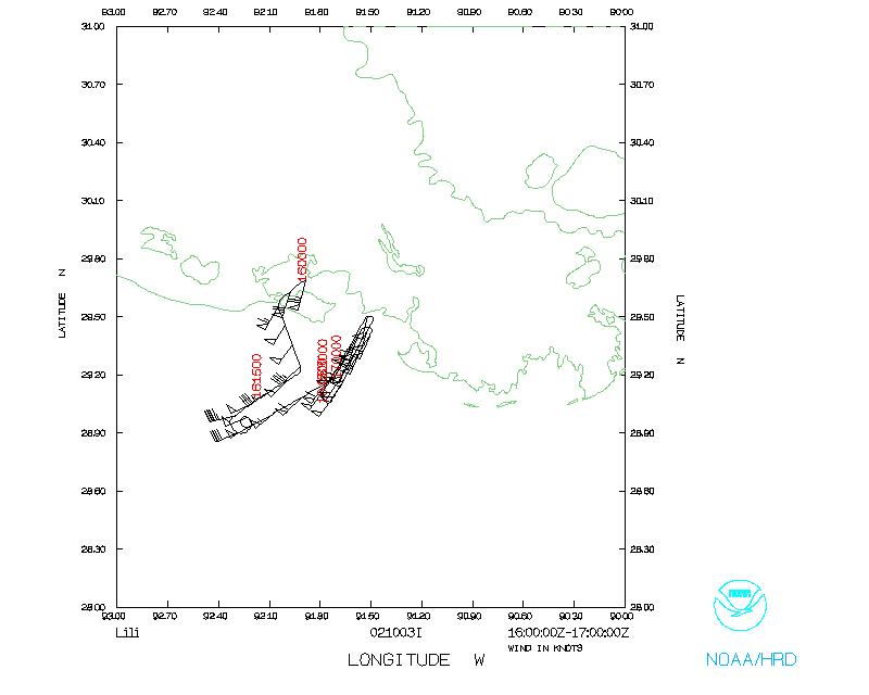
(Figure 2b), turning west towards
Lake Charles and then turning SE to head back to base. NOAA 43
landed at MacDill AFB later that day.
Figure 2a is an LF radar image
from NOAA 43's initial pass through the center of Lili.
The CBLAST module began at 1623 when the aircraft desended to
900'. The plane flew an upwind and downwind pass at this alittude
and then the aircraft descended to 600' for another leg. At 1702
the plane turned and ascended to 2000' for a crosswind leg.
Because of the numerous oil rigs with heights of 200' to 300',
the aircraft would not go below 600'. The crosswind legs were
completed at 1740. The aircraft climbed to 14,000' and then made
one south to north pass through the center over land
(Figure 2b), turning west towards
Lake Charles and then turning SE to head back to base. NOAA 43
landed at MacDill AFB later that day.
Evaluation :
 This is probably the most complete data set collected in a
landfalling hurricane (with the exception of the LCH radar data).
Hurricane Lili has weakened considerably over night, yet some of
the TTU towers measured hurricane-force winds. The wind towers
measured winds in various exposures and environments and these
data will be valuable for wind enginerring studies. Preliminary
examination of the Tail Doppler radar data show them to be free of
noise problems.
This is probably the most complete data set collected in a
landfalling hurricane (with the exception of the LCH radar data).
Hurricane Lili has weakened considerably over night, yet some of
the TTU towers measured hurricane-force winds. The wind towers
measured winds in various exposures and environments and these
data will be valuable for wind enginerring studies. Preliminary
examination of the Tail Doppler radar data show them to be free of
noise problems.
The flight crew also further practised flying low-altitude
patterns for the CBLAST experiment. One important finding was the
difficulty of flying these patterns near the Gulf Coast because of
the oil rigs
Acknowledgements :
Barry Damiano, John Adler, and the flight crew flew a complicated
pattern with thier usual dedication and attention to detail. Jeff
Smith kept the radar running, and Ray Tong and Damon San Souci
managed to keep up with our evolving plans for the GPS sonde
drops.
Mission Data
One minute listing
Table 1
Center fixes
Time
(UTC) |
Lat
°N |
Lon
°W |
Source |
| 09:00 |
27° 42' |
91° 42' |
NHC Official |
| 15:00 |
29° 50' |
92° 16' |
U.S. Air Force radar center |
| 15:16 |
29° 52' |
92° 18' |
NOAA 43 |
| 18:06 |
30° 31' |
92° 27' |
NOAA 43 |
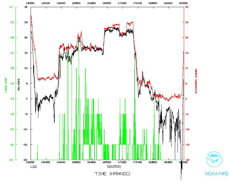
PDF plots of dropsonde data
Table 2
GPS sonde drops
| DROP LOCATIONS |
| Drop # |
sonde ID |
TIME
(UTC) |
LAT
(°N) |
LON
(°W) |
errors |
| 1 | 014335072 | 142338 | 28.55° | 89.00°
|
| 2 | 014415035 | 142852 | 28.60° | 89.38°
|
| 3 | 014335070 | 143414 | 28.64° | 89.77°
|
| 4 | 014335076 | 143904 | 28.71° | 90.13°
|
| 5 | 014335036 | 144408 | 28.83° | 90.50°
|
| 6 | 014335074 | 144905 | 28.95° | 90.86°
|
| 7 | 014335073 | 145404 | 29.08° | 91.21°
|
| 8 | 014515063 | 145905 | 29.22° | 91.55°
|
| 9 | 014515062 | 150046 | 29.26° | 91.67°
|
| 10 | 014515060 | 150525 | 29.45° | 91.96°
|
| 11 | 014515058 | 150837 | 29.67° | 92.10°
|
| 12 | 014515056 | 153159 | 29.00° | 92.33°
|
| 13 | 014335095 | 153458 | 29.15° | 92.13°
|
| 14 | 014515065 | 153803 | 29.31° | 91.92°
|
| 15 | 014335025 | 154136 | 29.49° | 91.67°
|
| 16 | 014335078 | 154404 | 29.62° | 91.74° | no winds |
| 17 | 014515061 | 154548 | 29.67° | 91.87° | no winds |
| 18 | 014335049 | 155818 | 29.64° | 91.76°
|
| 19 | 014515010 | 155938 | 29.68° | 91.86° | no winds |
| 20 | 014515121 | 160407 | 29.56° | 92.05°
|
Several of these sondes had late launch detects and late winds.
Table 3
AXBT drops
| DROP LOCATION |
TIME
(UTC) |
LAT
(°N) |
LON
(°W) |
SST
(°C) |
| 14:34 |
28° 39' |
89° 31' |
Table 4
Locations of mobile intruments deployed during the landfall
| Latitude |
Longitude |
Location |
| 30° 12' 27.72" | 91° 59' 23.64" | SMART-R Lafayette Regional Airport
|
| 30° 02' | 91° 54' | DOW3 Acadiana Airport (New Iberia)
|
| 30° 42.5' | 92° 06.5' | DOW2 St Landry Parish Airport (Opelousas)
|
| 30° 05.08' | 91° 00.37' | Clemson/U Fla near Cane Air Field
|
| 29° 54.84' | 91° 45.56' " | New Iberia
|
| 30° 22.07' | 91° 05.53' " | S of Baton Rouge
|
| 30° 12.88' | 92° 02.68' " | Cajun Field, Lafayette
|
| 29° 55' 06.3" | 92° 14' 50" | TTU tower at Old Harrington Landing Field
|
| 29° 55' 07" | 92° 14' 45.9" | TTU tower 2 " " (near Cow Island)
|
| 29° 45' 4.62" | 91° 43' 30.36" | TTU Wemite # 2, W. Cote Blanche Island (30' salt dome)
|
| 30° 01' 48.96" | 91° 52' 40.74" | TTU tower Acadiana Airport
|
| 29° 42' 32" | 91° 20' 40.2" | TTU 3m tower at Williams Memorial Airport
|
| 29° 42' 48.5" | 91° 20' 9.8" | TTU 3m Tower 2 at " " " ( near Patterson )
|
| 31° 10' 40" | 92° 24' 38" | LAIS Dean Lee (E of Woodworth, LA)
|
| 30° 14' 28" | 92° 20' 51" | LAIS Rice (E of Crowley, LA)
|
| 29° 57' 54" | 91° 42' 54" | LAIS Iberia (NW of Jeanerette, LA)
|
| 29° 59' 08" | 91° 04' 45" | LAIS Paincourtville (W of Paincourtville, LA)
|
| 29° 26' 28.2" | 92° 03' 40.8" | CSI-3
|
| 29° 10' | 90° 35' | CSI-11
|
| 29° 03.2' | 90° 32' | CSI-5
|
| 28° 52' | 90° 29' | CSI-6
|
Some locations were supplied by the teams,
others were read off of aeronautical chart CH-24.
DOW - Doppler On Wheels (University of Oklahoma/NSSL)
SMART-R - Texas A&M University/NCAR/Texas Tech
TTU - Texas Tech University Wind Engineering
LAIS - Louisiana Agroclimatic Information System
CSI - WAVCIS-LSU Coastal Studies Institute
Data Values |
 |
 |
Return to Mission page.