Mission Summary
20021001N2 Aircraft 49RF
Synoptic Surveillance flight
around Hurricane Lili 2002
| Sonde Scientist | Chris Landsea |
| Sonde Scientist | Rob Rogers |
| Sonde Scientist | Chris Landsea |
| Sonde Scientist | Rob Rogers |
The G-IV jet, with scientific crew of Chris Landsea and Rob Rogers, will conduct an NHC-tasked synoptic surveillance mission around Hurricane Lili at the nominal time of 0 UTC/October 2. Take-off time will be at 1:30 PM EDT from MacDill AFB and landed at 10 PM EDT in MacDill AFB, FL.
Mission Summary :
A phone call was made to the Hurricane Specialist on Duty, Stacey Stewart. The following important information was relayed :
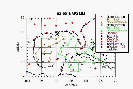
| DROP LOCATIONS | |||
| Drop # | LAT (d m) |
LON (d m) |
TIME (h:mm) |
| 1 | 25 02 | 83 48 | 0:25 |
| 2 | 23 14 | 82 58 | 0:41 |
| 3 | 23 15 | 80 00 | 1:04 |
| 4 | 25 07 | 78 45 | 1:22 |
| 5 | 27 00 | 77 30 | 1:40 |
| 6 | 24 37 | 77 30 | 2:00 |
| 7 | 22 15 | 77 30 | 2:19 |
| 8 | 21 15 | 75 45 | 2:35 |
| 9 | 20 15 | 74 00 | 2:51 |
| 10 | 19 45 | 75 00 | 3:00 |
| 11 | 19 45 | 77 30 | 3:20 |
| 12 | 20 21 | 80 39 | 3:46 |
| 13 | 20 57 | 83 48 | 4:11 |
| 14 | 19 30 | 82 30 | 4:27 |
| 15 | 17 00 | 82 30 | 4:47 |
| 16 | 17 00 | 85 00 | 5:07 |
| 17 | 18 30 | 85 32 | 5:20 |
| 18 | 19 00 | 86 05 | 5:33 |
| 19 | 22 00 | 87 00 | 5:51 |
| 20 | 22 57 | 89 13 | 6:10 |
| 21 | 25 02 | 88 23 | 6:29 |
| 22 | 26 00 | 86 05 | 6:48 |
| 23 | 28 00 | 85 00 | 7:07 |
| TRACK DISTANCES | ||||||
| Drop # | LAT (d m) |
LON (d m) |
RAD/AZM (nm/dg) |
LEG (nm) |
TOTAL (nm) |
TIME (h:mm) |
| 0 | MACDILL | 0. | 0. | 0:00 | ||
| 1 | 25 03 | 83 48 | 180/45 | 183. | 183. | 0:25 |
| 2 | 23 15 | 82 59 | 180/85 | 118. | 301. | 0:41 |
| 3 | 23 15 | 80 00 | 172. | 473. | 1:04 | |
| 4 | 27 00 | 77 30 | 266. | 739. | 1:40 | |
| 5 | 22 15 | 77 30 | 285. | 1024. | 2:19 | |
| 6 | 20 15 | 74 00 | 236. | 1260. | 2:51 | |
| 7 | 19 45 | 75 00 | 65. | 1325. | 3:00 | |
| 8 | 19 45 | 77 30 | 146. | 1471. | 3:20 | |
| 9 | 20 58 | 83 49 | 180/135 | 374. | 1845. | 4:11 |
| 10 | 19 30 | 82 30 | 116. | 1961. | 4:27 | |
| 11 | 17 00 | 82 30 | 150. | 2111. | 4:47 | |
| 12 | 17 00 | 85 00 | 147. | 2258. | 5:07 | |
| 13 | 19 00 | 86 06 | 180/180 | 191. | 2449. | 5:33 |
| 14 | 22 00 | 87 00 | 131. | 2580. | 5:51 | |
| 15 | 22 57 | 89 14 | 180/269 | 141. | 2720. | 6:10 |
| 16 | 25 03 | 88 24 | 180/315 | 134. | 2855. | 6:29 |
| 17 | 26 00 | 86 06 | 180/ 0 | 143. | 2997. | 6:48 |
| 18 | 28 00 | 85 00 | 135. | 3132. | 7:07 | |
| 19 | MACDILL | 140. | 3273. | 7:26 | ||
Return to Mission page.