Mission Summary
20020930N1 Aircraft 49RF
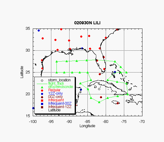
Synoptic Surveillance flight
around Hurricane Lili 2002
| Sonde Scientist | Chris Landsea |
| Sonde Scientist | Rob Rogers |
| Sonde Scientist | Chris Landsea |
| Sonde Scientist | Rob Rogers |
The G-IV jet, with scientific crew of Chris Landsea and Rob Rogers, conducted an NHC-tasked synoptic surveillance mission around Hurricane Lili at the nominal time of 00 UTC/October 1. Take-off time was at 1:30 PM EDT from MacDill AFB and landed at 10:10 PM EDT in MacDill AFB, FL.
Mission Summary :
A phone call was made to the Hurricane Specialist on Duty, Stacey Stewart. The following important information was relayed :
| DROP LOCATIONS | |||
| Drop # | LAT (d m) |
LON (d m) |
TIME (h:mm) |
| 1 | 27 30 | 77 30 | 0:38 |
| 2 | 26 15 | 75 55 | 0:54 |
| 3 | 25 00 | 74 20 | 1:10 |
| 4 | 25 00 | 75 55 | 1:22 |
| 5 | 25 00 | 77 30 | 1:35 |
| 6 | 23 14 | 79 31 | 1:56 |
| 7 | 22 52 | 76 56 | 2:17 |
| 8 | 22 30 | 74 20 | 2:37 |
| 9 | 20 00 | 74 00 | 2:58 |
| 10 | 19 34 | 76 45 | 3:20 |
| 11 | 19 09 | 79 31 | 3:42 |
| 12 | 18 12 | 81 47 | 4:02 |
| 13 | 19 09 | 84 04 | 4:22 |
| 14 | 21 09 | 84 54 | 4:39 |
| 15 | 22 30 | 87 00 | 4:59 |
| 16 | 23 14 | 84 04 | 5:23 |
| 17 | 25 00 | 85 00 | 5:39 |
| 18 | 25 00 | 87 07 | 5:55 |
| 19 | 25 00 | 89 15 | 6:12 |
| 20 | 25 00 | 91 22 | 6:28 |
| 21 | 25 00 | 93 30 | 6:45 |
| 22 | 27 30 | 93 30 | 7:05 |
| 23 | 27 35 | 90 45 | 7:27 |
| 24 | 27 40 | 88 00 | 7:48 |
| 25 | 27 45 | 85 15 | 8:09 |
| TRACK DISTANCES | ||||||
| Drop # | LAT (d m) |
LON (d m) |
RAD/AZM (nm/dg) |
LEG (nm) |
TOTAL (nm) |
TIME (h:mm) |
| 0 | MACDILL | 0. | 0. | 0:00 | ||
| 1 | 27 30 | 77 30 | 284. | 284. | 0:38 | |
| 2 | 25 00 | 74 21 | 234. | 518. | 1:10 | |
| 3 | 25 00 | 77 30 | 180. | 698. | 1:35 | |
| 4 | 23 15 | 79 31 | 180/45 | 157. | 854. | 1:56 |
| 5 | 22 30 | 74 21 | 301. | 1155. | 2:37 | |
| 6 | 20 00 | 74 00 | 151. | 1307. | 2:58 | |
| 7 | 19 10 | 79 31 | 180/135 | 326. | 1632. | 3:42 |
| 8 | 18 12 | 81 48 | 180/180 | 145. | 1777. | 4:02 |
| 9 | 19 10 | 84 05 | 180/225 | 145. | 1922. | 4:22 |
| 10 | 21 09 | 84 54 | 180/269 | 129. | 2051. | 4:39 |
| 11 | 22 30 | 87 00 | 146. | 2196. | 4:59 | |
| 12 | 23 15 | 84 05 | 180/315 | 174. | 2370. | 5:23 |
| 13 | 25 00 | 85 00 | 118. | 2488. | 5:39 | |
| 14 | 25 00 | 93 30 | 486. | 2974. | 6:45 | |
| 15 | 27 30 | 93 30 | 150. | 3124. | 7:05 | |
| 16 | MACDILL | 620. | 3744. | 8:30 | ||
Return to Mission page.