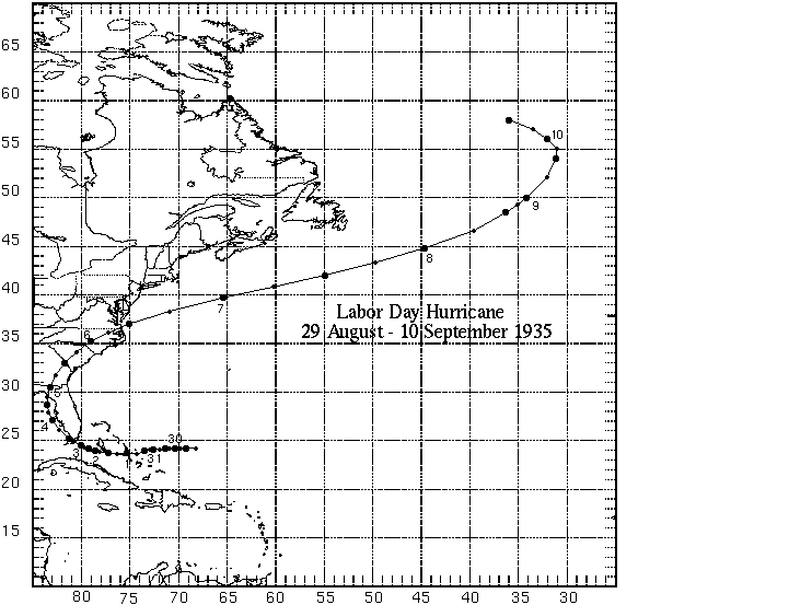
The full life history of the hurricane that devastated some of the Florida Keys on the afternoon and night of Labor Day, September 2, 1935, covers almost 2 weeks.
The first indications of conditions favorable to the origin of this disturbance were noted during the last 2 or 3 days of August, to the eastward and northward of Turks Islands; but it was not until August 31 that a definite depression appeared, near Long Island in the southeastern Bahamas, and deepened rapidly as it moved westward. The identity of the disturbance can be clearly followed from that region, over a long path around Florida and across the South Atlantic States to the North Atlantic Ocean, where, off southern Greenland, it was lost on September 10 by merging with a cyclone of extratropical origin. This path in its entirety is shown on chart.
Hurricane intensity was doubtless reached by the developing disturbance near the south end of Andros Island on September 1. Hurricane winds were last reported along the track on September 8 as the storm was moving northeastward over the Atlantic Ocean.
The vortex was at the stage of maximum violence, though still of small diameter, as it crossed the Florida Keys between Key West and Miami, September 2, moving northwestward. The central minimum barometer there was probably somewhat below 27 inches, as indicated by readings of three aneroids on the Keys, the values ranging from 26.75 to 26.98. Effort is being made to secure one or more of these instruments for testing, because any authenticated pressure value below 27 inches will constitute a new low record for the Western Hemisphere.
Attendant winds on September 2 were of phenomenal violence as is shown by physical effects almost equivalent to those experienced in tornadoes. One observer reported his house partially demolished by a wind-driven beam, 6 by 8 inches in section and 18 feet long, which was blown 300 yards from another building; this occurred at a time nearly 3 hours in advance of arrival of the calm center. It was this observer's impression that the winds were still more violent afterward. The lenses and 3/8-inch protecting glass of Alligator Reef Lighthouse, 135 feet above sea level, were reported to have been completely destroyed by the hurricane; and it is unlikely that this destruction could have been produced by flying debris.
It seems safe to estimate that winds of 150 to 200 miles per hour occurred near and over the Keys, with gusts probably exceeding 200 miles per hour.
Over a distance of about 30 miles, from the settlement of Tavenier (about 25°01' N., 80°32' W.) to Vaca Keys, the destruction of buildings, roads, viaducts, and bridges was practically complete. Much of this damage was caused by the overwhelming depth and strong washing flow of the storm tide that piled up on the Keys under the driving power of the storm. The tracks of the Florida East Coast Railroad were completely destroyed where they crossed between islands and were shifted bodily off their roadbed over long stretches on the Keys. An 11-car train, sent to Lower Matecumbe Key in an effort to rescue inhabitants, was washed from the tracks and only the locomotive withstood the force of wind and tide.
The disposition of debris and nature of the erosion of the railroad embankments clearly indicate that the destructive tide flowed with an intense effect over the Keys from southwest to northwest, in the direction of advance of the storm center.
As is usually the case, the destructive effects extended considerably farther to the right than to the left of the path of the center. Had there been no accompanying tide, the damage undoubtedly would have been severe but by no means so complete as that resulting from tidal inundation. The track and crossties of the railroad were in one stretch washed off a concrete viaduct 30 feet above ordinary water level, but wave action superimposed on the tide no doubt play a part in this destruction. Reports agreed in the description of the great rapidity with which the rise of the sea came in from the southern side of the Keys as a "wall of water" or a "high wave."
The Danish motorship Leise Maersk was carried over Alligator Reef and grounded nearly 4 miles beyond, after being totally disabled by the wind and sea, with engine room flooded. Captain Richard Morthensen described the grounding as follows: "Ship struck outer edge of Alligator Reef 9 o'clock (p.m.) and was carried over the reef by a wall of water inland 3 3/4 miles through the northward force of the wind, which was terrible." None of the crew was lost, though all superstructures were wrecked. The ship was salvaged September 20.
The American steamship Dixie was also carried aground somewhat farther north, on French Reef, without loss of life; this ship was refloated on September 19 and towed to New York. The American tanker Pueblo drifted helplessly in the storm from 2 to 10 p.m. of September 2; she went out of control near 24°40' N., 80°25' W., and was carried completely around the storm center, finding herself in 8 hours about 25 miles northeastward of her original position, and just barely able to claw off Molasses Reef as the force of the storm began to abate. The lowest barometer reading on the Dixie was 27.28 inches (corrected), and on the Pueblo, 27.18 inches (uncorrected).
The passage of the hurricane is graphically described in a report submitted by J.E. Duane, cooperative observer for the Weather Bureau, and in charge of a fishing camp on Long Key, over which the center passed. Extracts from his report follow, in the chronological order of his observations:
|
The wind lulled briefly between 8 and 9 p.m. at Alligator Reef, with direction shifting sharply from northeast to southeast; this point was just at the northern edge of the calm center. A calm of 40 minutes' duration was experienced on Lower Matecumbe Key; and, as reported above, there was 55 minutes' respite at Long Key fishing camp, but the wind changes at the latter point indicate that the geometric center passed slightly to northward. It is somewhat difficult to reconcile these reports with the general storm path. The rate of progression over this section of the track was about 10 miles per hour, however, and from this it is estimated that the calm center was perhaps eight miles in diameter.
The loss of life on the Keys was very heavy. Three populous relief work camps inhabited by war veterans were destroyed. The best estimate of mortalities, furnished by the American Red Cross, places the total at 409, of which number 244 are known dead and 165 missing.
The rescue of survivors was greatly hampered by lack of all means of communication and transport; but the Coast Guard promptly threw into the work 18 cutters, tugs, and patrol boats, 5 amphibians, and other facilities. The Red Cross and other public and private agencies of rescue were also promptly at work, so that the aftermath of fatalities from injuries and lack of supplies was held to a minimum.
After passing the Keys, the hurricane moved slowly into a broad recurve northward, closely parallel to the west coast of the Florida Peninsula, to pass inland, on the afternoon of Spetember 4, over the Gulf coast between Apalachicola and Cedar Keys. The times of lowest barometer at various places along the coast northward from Key West give a good indication of the rate of progress. At Everglade (on the west coast about opposite Miami) the lowest barometer reading was 29.69 inches 6 a.m. , September 3; at Egmont Key (entrance to Tampa Bay), 28.94, 11 p.m. of the 3d; and at Cedar Keys, 29.08, 1:50 p.m. of the 4th.
A slow incease in hurricane area took place along this part of the path, coincident with a decrease in central intensity, although the storm was still of hurricane force when it passed inland. Considerable damage to buildings, docks, and fishing craft occurred on the west coast, especially at Cedar Keys, and three lives were lost.
Northward along the west coast of the peninsula the tides shifted from abnormally low stages produced by the high offshore winds of the front quarter, to a heavy but not disastrous rise as the onshore winds in the rear came into play. Tides at many places on that coast rose 5 feet or more above normal, after the passage of the trough line; and the town of Cedar Keys experienced the highest tide and the worst flooding since 1896.
During September 5 the storm moved from Georgia across the Carolinas, attended by high winds and heavy rains that caused some damage to property and crops, especially in southern Georgia. On the morning of September 6 the center of disturbance passed again into the Atlantic near Cape Henry, Va., where the lowest barometer was only 29.31 inches, showing that there had been a great decrease in intensity of the storm during progress over the Atlantic coastal plain.
The cyclone deepened again on moving out to sea; and on the morning of September 7 the American steamer Excelsior recorded a barometer reading of 28.46 with a whole gale from the south, shifting suddenly to storm force from the north, near 42°N., 54°W. The central minimum continued below 29 inches for two days longer. The American steamer Black Condor recorded 28.02 inches on the evening of the 8th, near 51°N., 31°W.; and on the 9th the Danish ship Frederic VIII recorded a reading of 28.73 inches near 55°N., 35°W., a considerable distance from the center. The cyclone was at that time diminishing in intensity and merging with another, so that by the 10th it could be no longer distinguished from the cyclonic condition commonly present at high latitudes in the North Atlantic Ocean.
Total property losses entailed by this hurricane are very difficult to estimate, but doubtless exceed $6,000,000; practically all the loss was suffered in Florida, and most of it over the Florida Keys.