Mission Summary
20110906N1 Aircraft 49RF
Saharan Air Layer Interaction Mission Hurricane Katia
Aircraft Crew (49RF)
| Aircraft Commander | Jeff Hagen |
| Co-pilot | Nick Toth |
| Co-pilot | Ron Moyers |
| Flight Director | Rich Henning |
| ASPEN operator | Nick Morgan |
| Data Technician | Gabe Defeo |
| AVAPS Operator | Mike Mascaro |
| AVAPS Operator | Steven Paul |
| Dropsonde Operator | Alan Goldstein |
Science Crew (49RF)
| Lead Scientist | Jason Dunion
|
Mission Plan :
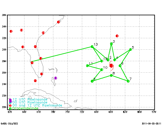
NOAA 49RF will fly an HRD-tasked Saharan Air Layer Interaction mission around
Hurricane Katia. The G-IV will leave MacDill AFB, FL 1100 UTC and will recover
back at MacDill AFB, FL by 1900 UTC that day.
HURRICANE SALEX MISSION PLAN: Katia
Prepared by the
Hurricane Research Division
Aircraft: N49RF
Altitude: FL410-450
Proposed takeoff: 06/1100 Z
|
TURN LOCATIONS
|
| #
| LAT
| LON
| LEG
| TOTAL
| TIME
|
|
| deg min
| deg min
| naut mile
| naut mile
| hh:mm
| | 0 | MACDILL | 0. | 0. | 0:00
| | 1 | 30 30 | 69 51 | 683. | 683. | 1:43
| | 2 | 28 12 | 66 33 | 221. | 905. | 2:13
| | 3 | 31 00 | 65 51 | 172. | 1077. | 2:36
| | 4 | 28 12 | 65 09 | 172. | 1249. | 3:00
| | 5 | 30 00 | 61 51 | 204. | 1453. | 3:27
| | 6 | 27 12 | 64 03 | 204. | 1658. | 3:55
| | 7 | 24 30 | 62 21 | 187. | 1844. | 4:20
| | 8 | 25 30 | 65 51 | 200. | 2044. | 4:48
| | 9 | 24 30 | 69 51 | 226. | 2270. | 5:18
| | 10 | 26 30 | 67 51 | 162. | 2432. | 5:40
| | 11 | 27 12 | 70 51 | 166. | 2599. | 6:03
| | 12 | 28 00 | 67 51 | 167. | 2765. | 6:25
| | 13 | 30 30 | 69 51 | 183. | 2949. | 6:50
| | 14 | MACDILL | 683. | 3632. | 8:33
| |
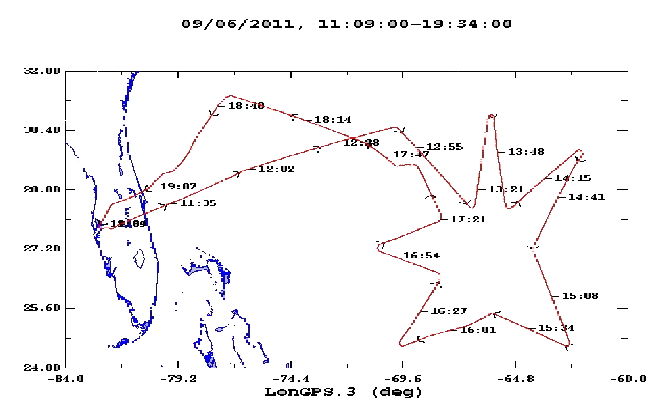
Mission Summary :
| Take off
| Landing
| MacDill AFB, FL | 11:09 UTC
| MacDill AFB, FL | 19:34 UTC
| |
26 dropsondes released, all 26 released.
Problems :
Mission Data :
NetCDF file |
Flight Director log |
Dropsonde log
Page last updated September 21, 2011
Return to Mission page.