Mission Summary
20020925I Aircraft 43RF
Tropical Storm Isidore Landfall and
Reconnaissance/ Ocean survey mission
Scientific Crew
| Lead scientist | Joe Cione |
| Workstation scientist | Peter Dodge |
| AXBT scientists | Eric Uhlhorn |
| SRA scientist | Ed Walsh (NASA) |
| Guest scientist | David Nolan (RSMAS) |
Aircraft Crew (43RF)
| Cockpit |
CDR Phil Kenul
LCDR H Halverson |
| Navigator |
LCDR Carl Newman |
| Flight Director |
Barry Damiano |
| Engineer |
Jeff Smith |
| Data Tech |
Terry Lynch
Ray Tong |
| Elctronics |
Damon Sans Souci |
Mission Briefing:
This final flight in Tropical Storm Isidore was to be a tasked
mission for the Tropical Prediction Center. Joe Cione and Eric
Uhlhorn came up to Tampa the day before in hopes of obtaining
data to further validate the Stepped Frequency Micowave Radiometer
(SFMR) surface wind speed estimates. This would be accomplished
by flying over buoys and C-MAN stations at different altitudes,
while also deploying AXBTs and GPS sondes. A flight plan was drawn
up that would satisfy the operational requirements, accomplish
the buoy overflights, and include one run along the coast to
gahter landfall data near the wind towers and portable radars
that were being deployed by various university groups.
The plan had to changed quite a bit when, at the pre-flight
briefing, it was pointed out that the planned take off time would
require us to head straight to the center in order for AOC to make
the 00 UTC fix. The plan was amended accordingly with the help of
Barry and Carl.
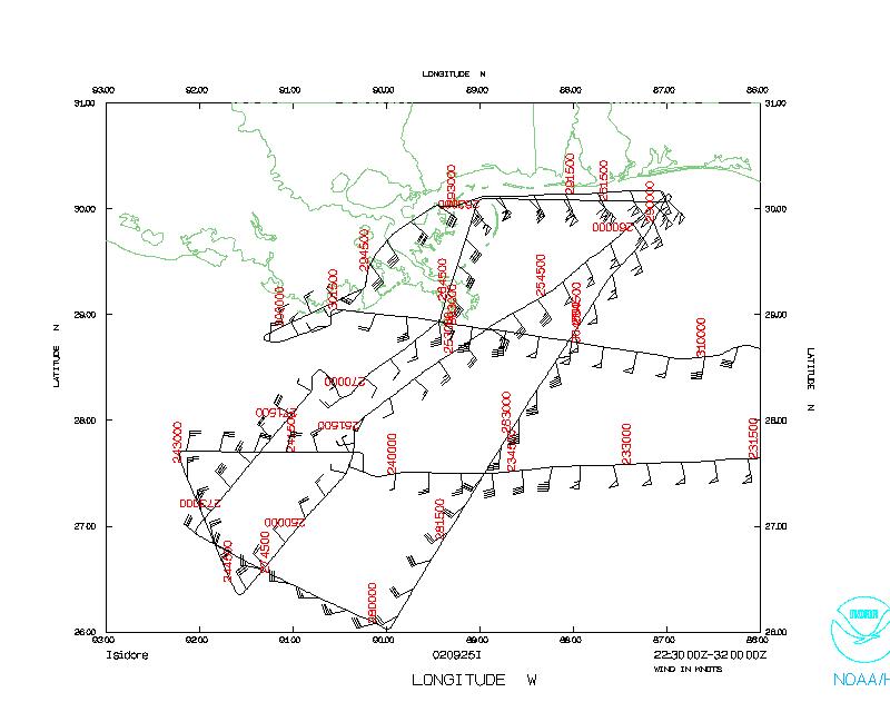
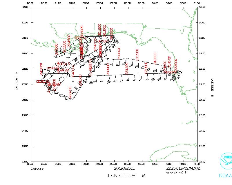
Mission Synopsis
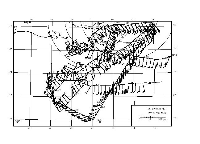 NOAA 43 left MacDill Air Force Base at 2230 UTC, and descended to
10,000' at the IP at 2333 UTC. Isidore had a huge circulation,
filling most of the Gulf, but the core had weakened after
landfall in Mexico and the center was not that easy to find. Barry
fixed the center at 27° 39' N, 90° 15' W at 0005 UTC. The
plane continued a figure 4 pattern, passing thorugh the center
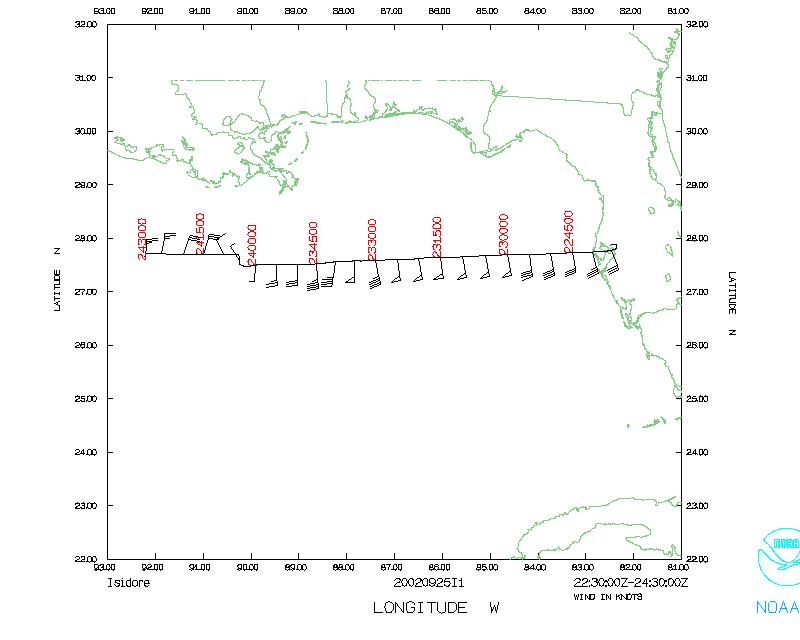
again at 0114 UTC. From 0206 to to 0222 UTC we flew west along the
coast, deployinmg sondes, most of which had no winds. We headed
south to get the 0300 UTC fix. At 0351 UTC Richard Pasch called
from TPC and requested that the P3 repeat the coastal pass, because
the wind max appeared to be around Gulfport. We repeated the
coastal run starting at 0502 UTC. Once again, most of the sondes
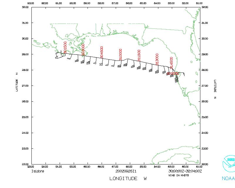
had no winds. At 0614 UTC Barry declared the storm center was
inland, near 29° and 90° 33'. We landed back at MacDill at
0759 UTC.
NOAA 43 left MacDill Air Force Base at 2230 UTC, and descended to
10,000' at the IP at 2333 UTC. Isidore had a huge circulation,
filling most of the Gulf, but the core had weakened after
landfall in Mexico and the center was not that easy to find. Barry
fixed the center at 27° 39' N, 90° 15' W at 0005 UTC. The
plane continued a figure 4 pattern, passing thorugh the center
again at 0114 UTC. From 0206 to to 0222 UTC we flew west along the
coast, deployinmg sondes, most of which had no winds. We headed
south to get the 0300 UTC fix. At 0351 UTC Richard Pasch called
from TPC and requested that the P3 repeat the coastal pass, because
the wind max appeared to be around Gulfport. We repeated the
coastal run starting at 0502 UTC. Once again, most of the sondes
had no winds. At 0614 UTC Barry declared the storm center was
inland, near 29° and 90° 33'. We landed back at MacDill at
0759 UTC.
Mission Evaluation:
HRD was not able to accomplish many of the scientific
objectives during this flight because of the changing nature of
the operational mission. It was an excellent training opportunity
for newer HRD personnel to get involved in the field program more
directly. This just reinforced the need for HRD to be flexible when
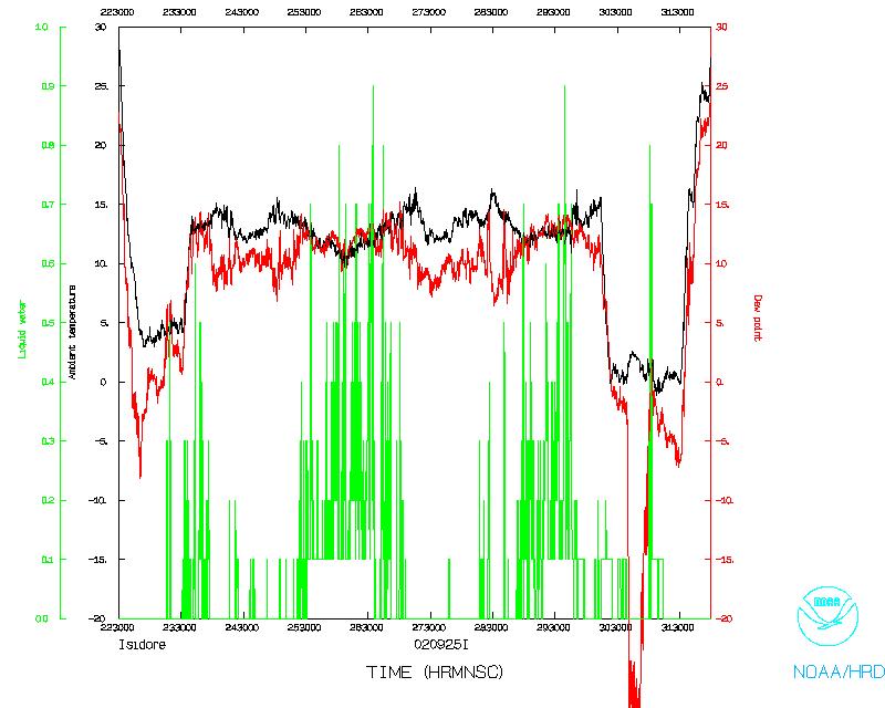
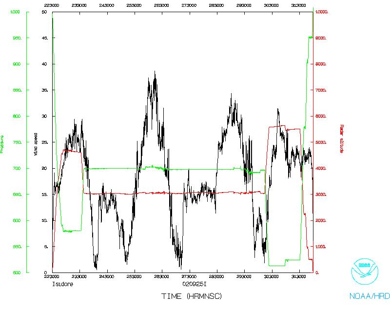
tagging along on tasked flights. Valuable radar and flight-level
data were collected on the coastal runs, and if the GPS sonde
winds can be recovered, they will also prove useful in further
validation of the remote surface wind estimates.
One minute listing
Problems:
There were numerous failures of the GPS sonde winds. These
may be recovered in post-processing at AOC.
Acknowledgements:
Barry Damiano, Carl Newman, and the flight crew tried to
include our research objectives in the flight track whenever
possible. Terry Lynch kept the radar running, and Jeff Smith,
Ray Tong and Damon Sans Souci managed to keep up with our evolving
plans for GPS sonde and AXBT drops.
Tables
Table 2
GPS Sondes
from John Gamache's sonde log
| # | Sonde ID | time | Lat (°) | Lon (°) | Comments
|
| 1 | 984715169 | 000551 | 27.67 | 90.25 | At circ center
|
| 2 | 011838009 | 014646 | 29.25 | 88.20 | Near 42040
|
| 3 | 021735094 | 020845 | 30.06 | 87.05
|
| 4 | 022918046 | 021514 | 30.07 | 87.67 | No winds
accidentally teminated at 52 sec.
|
| 5 | 021735226 | 021829 | 30.07 | 87.97
|
| 6 | 993925231 | 022219 | 30.08 | 88.32 | Intermittent winds
no winds below 924 mb
|
| 7 | 022918061 | 023053 | 30.00 | 89.05 | No winds
|
| 8 | 022945191 | 024832 | 28.90 | 89.48 | No winds
|
| 9 | 011838026 | 025044 | 28.20 | 89.64 | late winds
|
| 10 | 022918057 | 030743 | 28.45 | 90.65 | just N of center
|
| 11 | 993818040 | 040229 | 26.07 | 89.93 | Failed
|
| 12 | 011115068 | 040343 | 26.15 | 89.88
|
| 13 | 021735078 | 050502 | 30.17 | 87.15 | Sonde ended at 850 mb
|
| 14 | 020615260 | 051055 | 30.15 | 87.67 | No winds
|
| 15 | 020615293 | 051328 | 30.13 | 87.88 | winds at 87 sec for ~20 sec
|
| 16 | 011115053 | 051833 | 30.13 | 88.38 | No winds
|
| 17 | 020615299 | 052635 | 30.08 | 89.02 | No winds
|
| 18 | 020215227 | 055800 | 28.93 | 90.98 | West of center
|
Winds may be recovered from the no-wind sondes in post processing.
Table 3
AXBTs
from Gamache sonde log
| # | Lat | Lon
| Launch
(UTC) | SST
(°C)
| Comments
|
| 1 | 27.32 | 88.32 | 2343 | 27.6
|
| 2 | 27.43 | 92.10 | 0029 | 28.2
|
| 3 | 26.28 | 91.26
|
| 4 | center | 0114 | -
|
| 5 | 29.25 | 88.20 | 0146 | 28.1 | Near 42040
|
| 6 | 28.90 | 89.48 | 0248 | 23.0 | 10 m depth
|
| 7 | 26.07 | 89.93 | 0402 | - | Near 42001
|
Table 4
Locations of mobile intruments deployed during the landfall
| Latitude | Longitude | Location
|
| 30° 14 | 87 41' | FSU Portable Doppler Radar
|
| 30° 24'50.3" | 89° 04'06.7" | WEMITE 2 Gulfport airport
|
| 30° 24'50.3" | 89° 04'06.7" | UAH Profiler
|
| 30° 24'49.1" | 89° 04'10.3" | SBCCOM 10 m mesonet
|
| 30° 24'51.0" | 89° 04'10.2" | SBCCOM 10 m mesonet
|
| 30° 22'12.1" | 89° 04'42.4" | SBCCOM 3 m mesonet Gulfport Beach before move
|
| 30° 22'12.4" | 89° 04'42.4" | After move (moved due to surge threat)
|
| 29 42'50.4" | 91° 20'08.8" | 10 m mesonet Harry P. Williams Airport,
|
| 29 42'39.5" | 91° 20'14.9" | 3 m mesonet Patterson, LA
|
Some locations were supplied by the teams, others were
read off of aeronautical chart CH-24.
TTU - Texas Tech University Wind Engineering
UAH - University of Albama/Huntsville
FSU - Florida State University
Return to Mission page.