Mission Summary
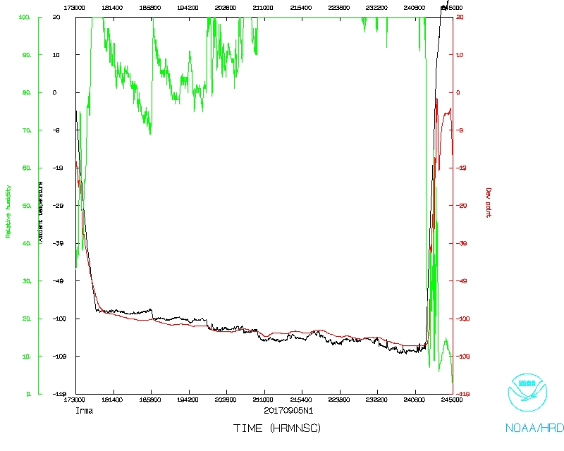
20170905N1 Aircraft 49RF
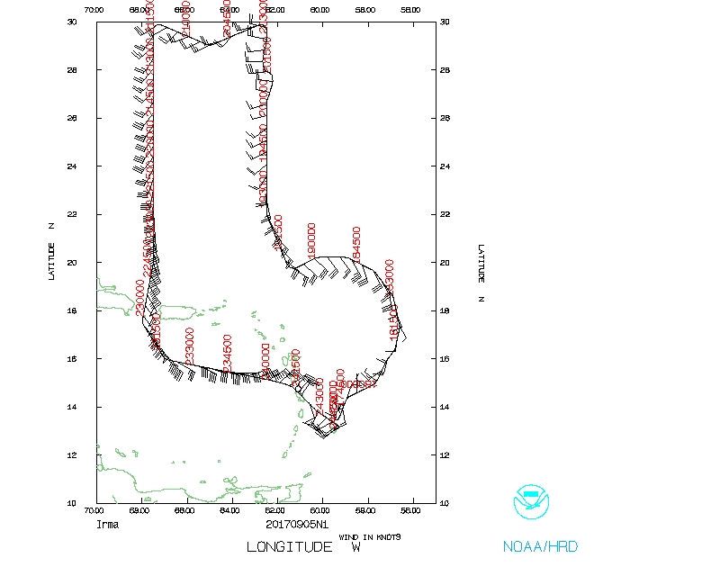
Hurricane Irma (AL11)
Synoptic Surveillance
Aircraft Crew (49RF)
| Aircraft Commander | Kristie Twining
|
| Co-pilot | Fitzler
|
| Co-pilot | Tanner Sims
|
| Flight Director | Rich Henning
|
| Flight Director | Jess Williams
|
| System Engineer | Joe Greene
|
| Data Technician | Gabe Defeo
|
| Dropsonde Operator | Delgado
|
| Dropsonde Operator | Patel
|
Mission Plan :
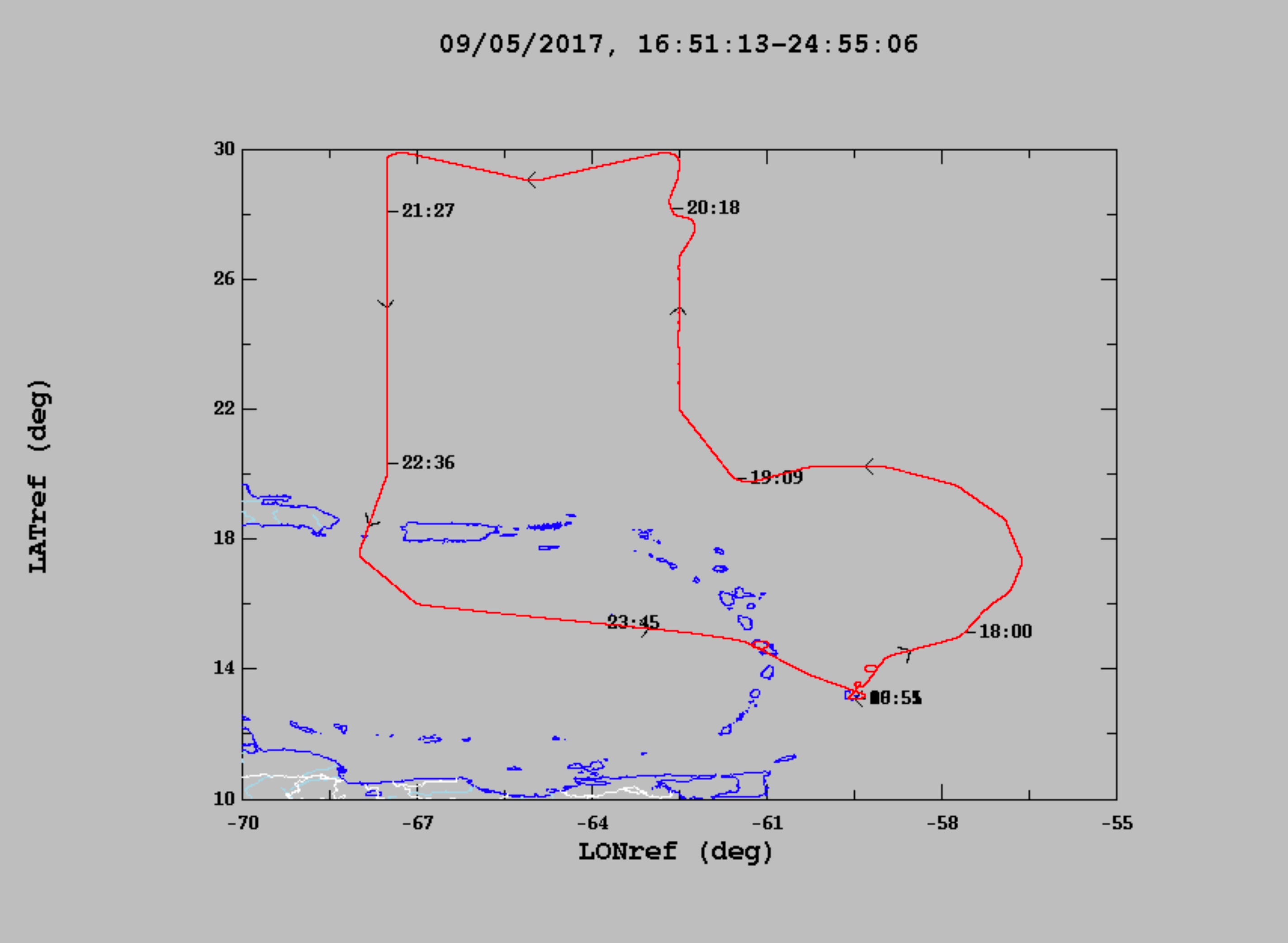
NOAA 49RF (N49) will fly a synoptic surveillance mission from Barbados into
Hurricane Irma.
HURRICANE SYNOPTIC SURVEILLANCE MISSION PLAN: IRMA
Prepared by the National Hurricane Center
September 04, 2017 4:16:34 PM
Aircraft: N49RF
Proposed takeoff: 05/1730Z
|
|
DROP LOCATION TABLE
|
| #
| LAT
| LON
| Time
|
|
| deg min
| deg min
| hr:min
|
| 1 | 14 23 | -58 56 | 0:12
|
| 2 | 14 57 | -57 44 | 0:22
|
| 3 | 16 00 | -56 54 | 0:33
|
| 4 | 17 18 | -56 36 | 0:44
|
| 5 | 18 36 | -56 54 | 0:55
|
| 6 | 19 39 | -57 44 | 1:06
|
| 7 | 20 13 | -58 56 | 1:17
|
| 8 | 20 13 | -60 16 | 1:27
|
| 9 | 19 39 | -61 28 | 1:38
|
| 10 | 22 00 | -62 30 | 1:59
|
| 11 | 24 00 | -62 30 | 2:15
|
| 12 | 26 00 | -62 30 | 2:31
|
| 13 | 28 00 | -62 30 | 2:48
|
| 14 | 30 00 | -62 30 | 3:04
|
| 15 | 29 00 | -65 00 | 3:25
|
| 16 | 30 00 | -67 30 | 3:46
|
| 17 | 28 00 | -67 30 | 4:02
|
| 18 | 26 00 | -67 30 | 4:18
|
| 19 | 24 00 | -67 30 | 4:35
|
| 20 | 22 00 | -67 30 | 4:51
|
| 21 | 20 00 | -67 30 | 5:07
|
| 22 | 17 30 | -68 00 | 5:28
|
| 23 | 15 59 | -66 59 | 5:43
|
| 24 | 15 43 | -65 36 | 5:54
|
| 25 | 15 28 | -64 14 | 6:06
|
| 26 | 15 13 | -62 51 | 6:17
|
| 27 | 14 57 | -61 28 | 6:28
|
Mission Summary :
| Take off
| Landing
| Barbados, BWI
| 17:22 UTC
| Barbados, BWI
| 00:47 UTC
| |
28 dropsondes launched, all good and sent.
Problems :
Mission Data :
Flight Director's manifest |
NetCDF data |
One second data
Page last updated Dec. 6, 2017
Return to Mission page.