Mission Summary
20110824N1 Aircraft 49RF
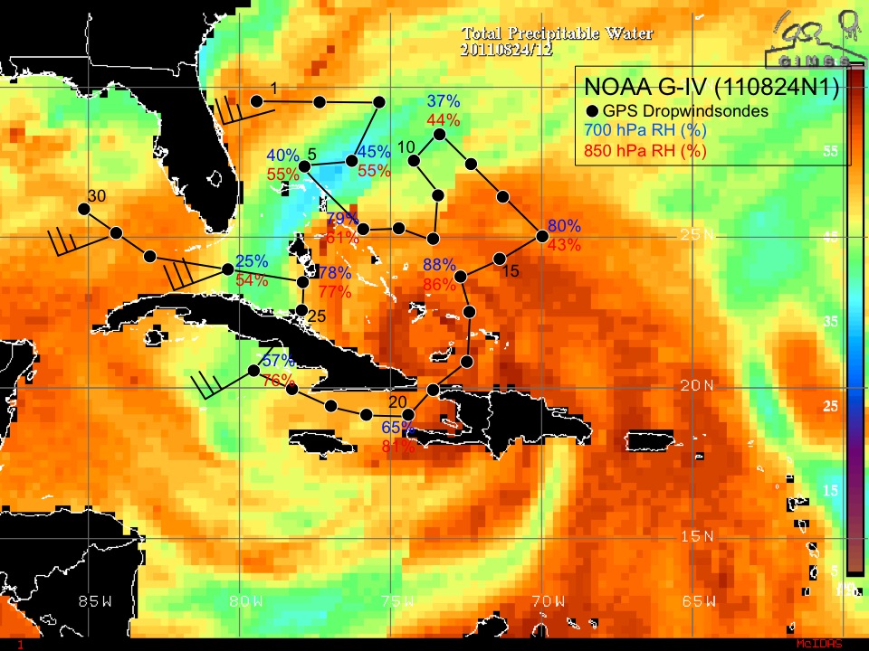
Synoptic Surveillance Mission Hurricane Irene
Aircraft Crew (49RF)
| Aircraft Commander | Greg Glover |
| Co-pilot | Kristie Twining |
| Co-pilot | Ron Moyers |
| Flight Director | Jack Parrish |
| Flight Director | Jess Williams |
| Data Technician | Mark Rogers |
| Dropsonde Operator | Mike Mascaro |
| Dropsonde Operator | Joe Greene |
Guests (49RF)
| Jeff Fournier (NWS Tallahassee)
|
Mission Plan :
NOAA 49RF will fly an NHC-tasked Synoptic Surveillancd mission around Hurricane
Irene. The G-IV will leave MacDill AFB, FL 0530 UTC and will recover
back at MacDill AFB, FL by 1400 UTC that day.
HURRICANE SYNOPTIC SURVEILLANCE MISSION PLAN: Irene
Prepared by the
National Hurricane Center
August 22, 2011 3:12:13 PM
Aircraft: N49RF
Altitude: FL410-450
Proposed takeoff: 24/0530Z
|
|
DROP LOCATIONS
|
| #
| LAT
| LON
| TIME
|
|
| deg min
| deg min
| hh:mm
|
| 1 | 29 00 | -79 00 | 0:29
|
| 2 | 29 00 | -77 00 | 0:44
|
| 3 | 29 00 | -75 00 | 0:59
|
| 4 | 27 00 | -76 00 | 1:17
|
| 5 | 27 00 | -78 00 | 1:33
|
| 6 | 24 55 | -75 40 | 1:58
|
| 7 | 24 55 | -74 20 | 2:08
|
| 8 | 24 21 | -73 08 | 2:18
|
| 9 | 26 00 | -73 00 | 2:32
|
| 10 | 27 00 | -74 00 | 2:43
|
| 11 | 28 00 | -73 00 | 2:55
|
| 12 | 27 00 | -72 00 | 3:06
|
| 13 | 26 00 | -71 00 | 3:17
|
| 14 | 25 00 | -70 00 | 3:28
|
| 15 | 24 00 | -71 00 | 3:40
|
| 16 | 23 18 | -72 18 | 3:51
|
| 17 | 22 00 | -72 00 | 4:02
|
| 18 | 20 42 | -72 18 | 4:13
|
| 19 | 19 57 | -73 31 | 4:25
|
| 20 | 19 05 | -74 20 | 4:34
|
| 21 | 19 05 | -75 40 | 4:45
|
| 22 | 19 26 | -76 52 | 4:55
|
| 23 | 19 43 | -78 14 | 5:06
|
| 24 | 20 36 | -79 20 | 5:17
|
| 25 | 22 32 | -77 42 | 5:38
|
| 26 | 23 18 | -77 42 | 5:44
|
| 27 | 23 35 | -80 02 | 6:02
|
| 28 | 25 30 | -83 30 | 6:34
|
| 29 | 25 30 | -85 30 | 6:49
|
| 30 | 25 30 | -87 30 | 7:05
|
| 31 | 27 30 | -87 30 | 7:21
|
| 32 | 29 30 | -87 30 | 7:37
|
| 33 | 27 30 | -85 30 | 7:60
|
Mission Summary :
| Take off
| Landing
| MacDill AFB, FL | 05:30 UTC
| MacDill AFB, FL | 13:54 UTC
| |
NOAA 49RF flew an NHC-tasked Synoptic Surveillancd mission around Hurricane
Irene. The G-IV left MacDill AFB, FL 0530 UTC and recovered back at MacDill
AFB, FL by 1354 UTC that day. 34 dropsondes were launched and 30 were
transimitted.
Problems :
Mission Data :
NetCDF flight level file |
Error Summary |
Flight Director's log
Page last updated November 09, 2011
Return to Mission page.