Mission Summary
20080912I1 Aircraft 43RF
EMC Tail Doppler Radar Operational Mission
Scientific Crew (43RF)
| Lead Project Scientist | Jason Dunion |
| Radar/Workstation Scientist | Mike Black |
| Doppler Scientist | Neal Dorst |
| AXBT Scientist | Ben Jaimes de la Cruz (UMiami) |
Flight Crew (43RF)
| Pilots | Barry Choy
Amelia Ebhardt
Brian Taggart
|
| Flight Director | Marty Mayeaux |
| Navigators | Joe Bishop
Ryan Kidder |
| Flt. Eng. | Dewie Floyd |
| Data Tech | Terry Lynch
Dana Naeher
Jeff Smith
|
| Elec. Tech | Damon Sans Souci |
Mission Plan :
NOAA 43RF will participate in an EMC Tail Doppler Radar mission (with options
to conduct HRD's TC-Ocean Interaction Experiment and SFMR shallow water module)
into Hurricane Ike. The flight called for an initial IP well NE of the center.
From the IP to a point north of the storm, NOAA 43 would fly at 5,000 ft
(pressure altitude) to collect SRA data over the coastline. Following that
long E-W leg, NOAA 43 would climb to 8,000 ft (pressure altitude) and begin a
N-S leg south of Marsh Island, LA with a series of GPS dropsondes/AXBTs for
HRD's SFMR shallow water module to investigate shoaling effects on SFMR
retrieved winds. Finally, a rotated figure four pattern will be conducted.
Since Ike's wind field had expanded quite a bit since the previous missions,
the leg lengths were extended to ~120 nm. GPS dropsondes would be launched in
the center, in areas with insufficient scatterers to derive Doppler winds and
in selected locations where AXBTs will be launched. AXBTs and AXBT/GPS
dropsonde combos will be targeted in areas of potential shoaling, locations
coincident with a pre-storm ocean survey mission flown on 08 September as well
as with NOAA drifting buoys in the area. Doppler wind and Super Ob analyses
will be transmitted off the plane in real-time, if possible. The flight track,
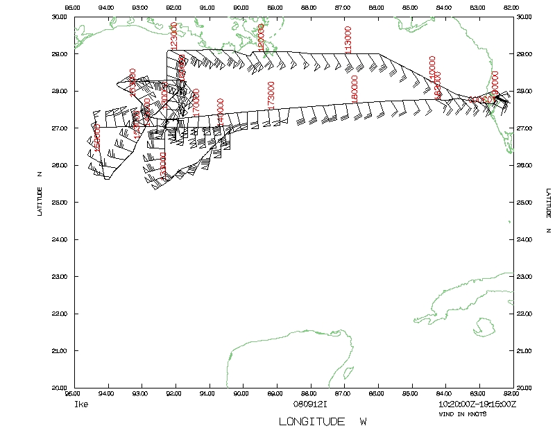
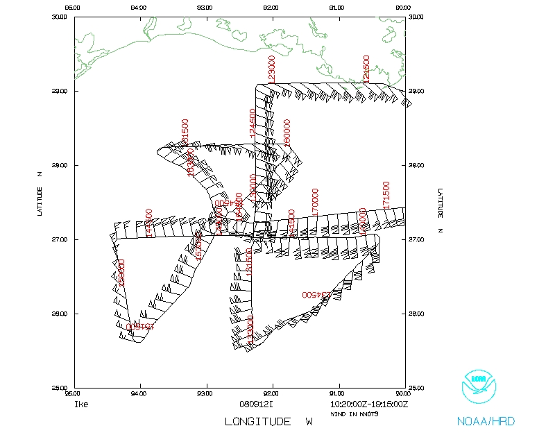
17 GPS dropsonde points and 20 AXBT points are shown in Fig. 1. The flight
track with overlaid tracks and positions of NOAA drifting buoys that were
deployed ahead of the storm are shown in Fig. 2
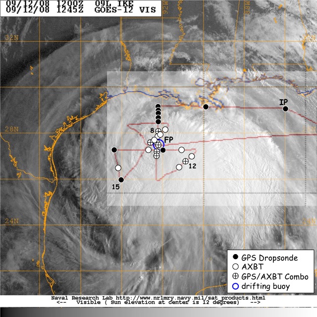
Fig. 1: Flight track (red line) for EMC Tail Doppler Radar mission
20080912I1. GPS dropsondes, AXBTs and AXBT/GPS dropsonde combos that were
launched are indicated by black circles, white circles and circled crosses
respectively. The blue circle indicates the position of a NOAA drifting buoy
that was overflown with a GPS dropsonde/AXBT combo.
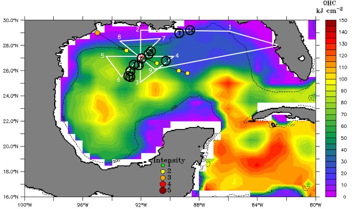
Fig. 2: Flight track (white line) for EMC Tail Doppler Radar mission
20080912I1. The black circles show the positions of several NOAA drifting
buoys that were launched ahead of the storm. Hurricane Ike's forecast track
is shown by the black line with forecast points (yellow circles). Altimeter-
derived ocean heat content values are indicated by the colored shading.
Mission Summary :
| Take off
| Landing
| MacDill AFB, FL | 10:32 UTC
| MacDill AFB, FL | 19:03 UTC
| |
- Synoptic Situation
On 12 August, Hurricane Ike was positioned on the southwest side of a deep
layer ridge that was centered over the southeast U.S. (Fig. 3, left).
Vertical wind shear analyses from UW-CIMSS indicated ~10-20 kt of shear over
Ike (Fig. 3, right). Figures 3 and 4 also indicate that northeasterly shear
was now present over the storm and that upper-level outflow appeared to be
improving, though it was somewhat restricted on the east and northeast sides
of the storm.
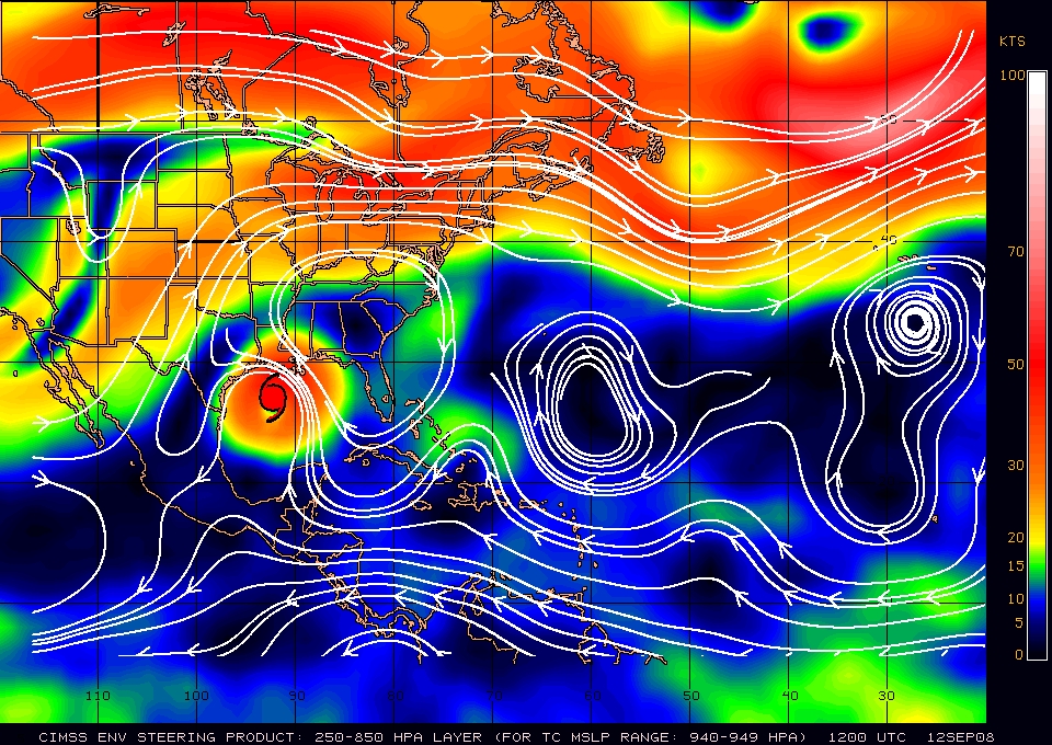
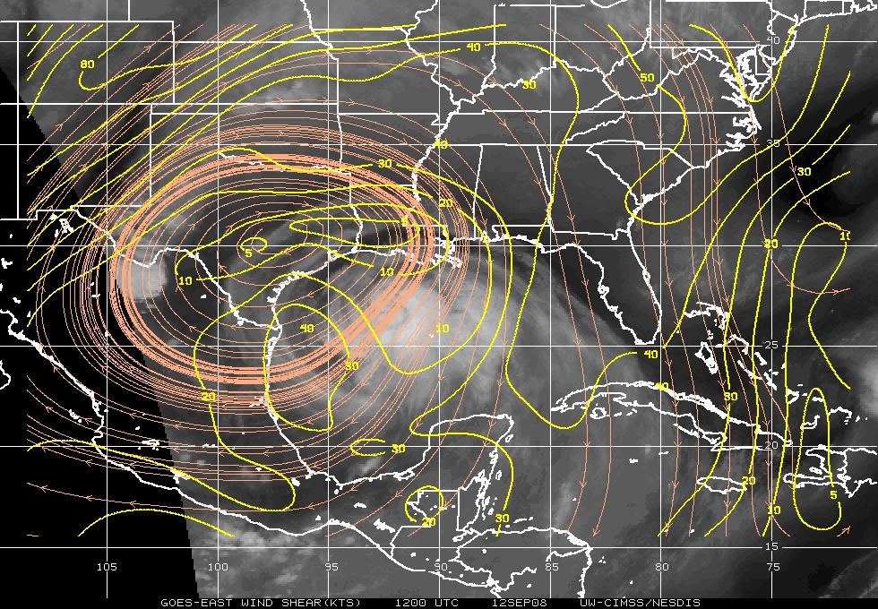
Fig. 3: (Left) plot of 250-850 hPa deep layer mean steering
[magnitude (direction) of the steering flow is indicated by colored shading
(white streamlines) and the storm center is shown by the red hurricane symbol]
for 12 Sept 1200 UTC. (Right) vertical wind shear [magnitude (direction) of
the wind shear is indicated by yellow contours (orange streamlines)]) for 12
Sept 1200 UTC. Images courtesy of UW/CIMSS.
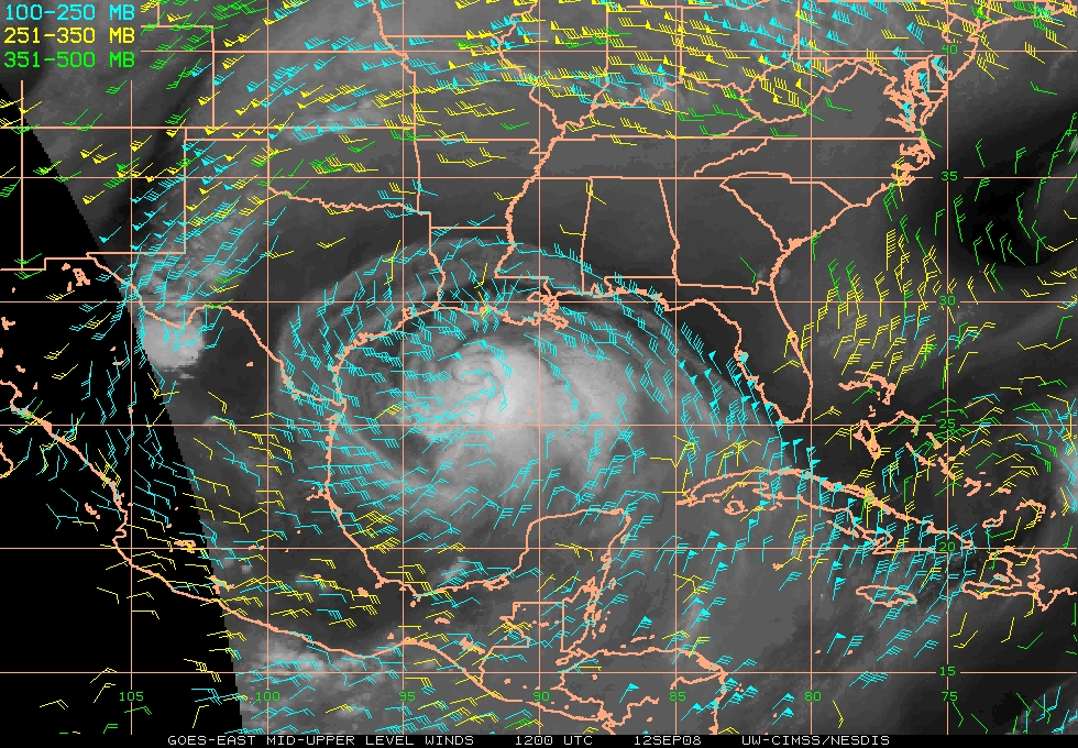
Fig. 4: Plot of mid to upper-level GOES water vapor winds for 12
Sept 1200 UTC. Image courtesy of UW/CIMSS.
- Mission Specifics
After a 2.5 hour delay (problems closing the APU hatch on NOAA 43),
take-off was from MacDill at 1032 UTC. Hurricane Ike was located at
~26.9°N 92.2°W, its intensity was 90 kt (954 hPa) and its forward
motion was 290 degrees at 11 kt. Figure 5 (left) shows an overpass by AMSR-E
on the Aqua (89 GHz) satellite and indicates that Ike's convection continued
to be quite asymmetric. Ike had a broad crescent shaped outer eyewall that
was confined to the south and southeast portion of the storm. The AMSR-E 89
GHz image and NOAA 43's LF radar indicated that the small inner eyewall that
had been present for the past few days had eroded, leaving behind a large eye.
The TRMM Precipitation Radar confirmed the asymmetry seen in the AMSR-E 89 GHz
image and indicated that high rain rates were virtually nonexistent in Ike's
NW quadrant. Additionally, HRD H*Wind surface wind analyses conducted at 1330
UTC (not shown) indicated that Ike's wind field was continuing to expand.
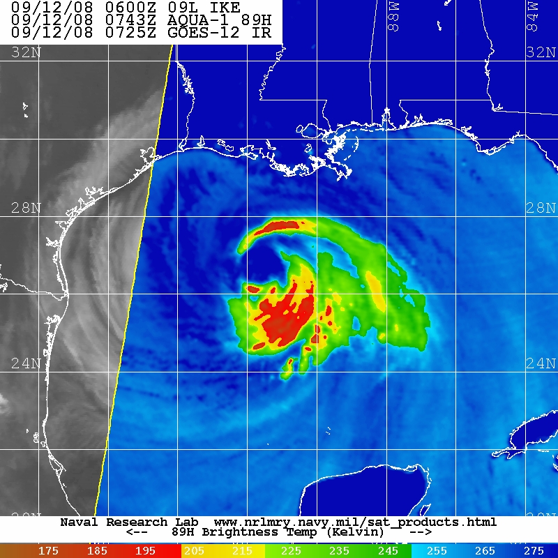
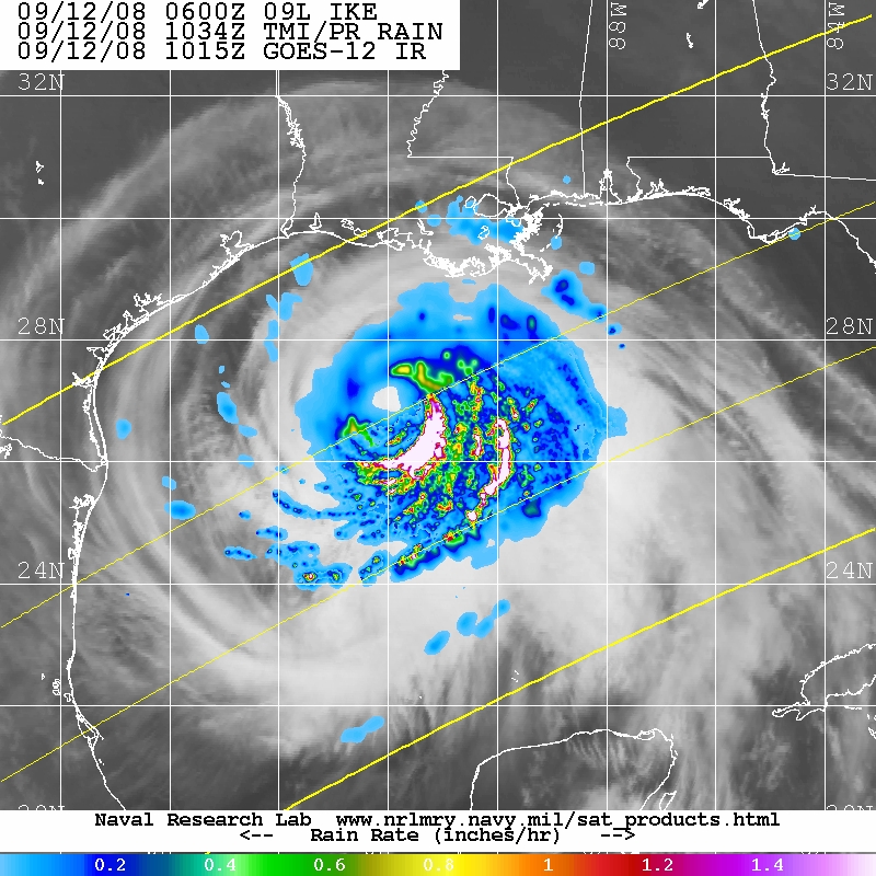
Fig. 5: Plots of (left) Aqua AMSR-E 89 GHz imagery for 12 Sept 0743
UTC and (right) TRMM Precipitation Radar imagery for 12 Sept 1034 UTC.
The 8.5 hour flight pattern was executed as planned, except that the last
center to NE leg was cut short (from 120 nm to 100 nm) to conserve extra fuel
that was burned during the long 5,000 ft pressure altitude portion of the
mission. The subsequent NW to center leg was therefore also shorter than
outlined in the original mission plan (from 120 nm to 100 nm). There were six
GPS dropsonde/AXBT combos and one overflight of a NOAA drifting buoy (with a
GPS dropsonde/AXBT combo) was made at drop #17. The lowest GPS dropsonde
pressure observed during the mission was 954.8 hPa at drop #10, during a pass
through the center at 1308 UTC. Two Doppler wind analyses were transmitted
off the P-3 in real-time during this mission. No Super Ob analyses were
transmitted since the Super Obs were not being assimilated in real-time that
day.
Problems :
Though there were no major problems during the flight, there were problems,
including:
- NOAA 43's APU hatch could not be properly closed before take-off, delaying
take-off by 2.5 hours
- 4 of the 20 AXBTs failed
Jason Dunion
29 April 2009
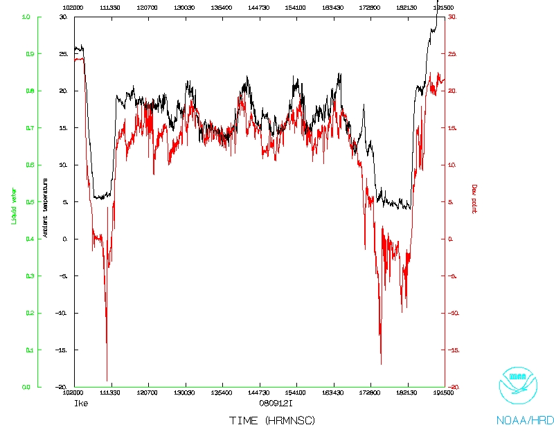
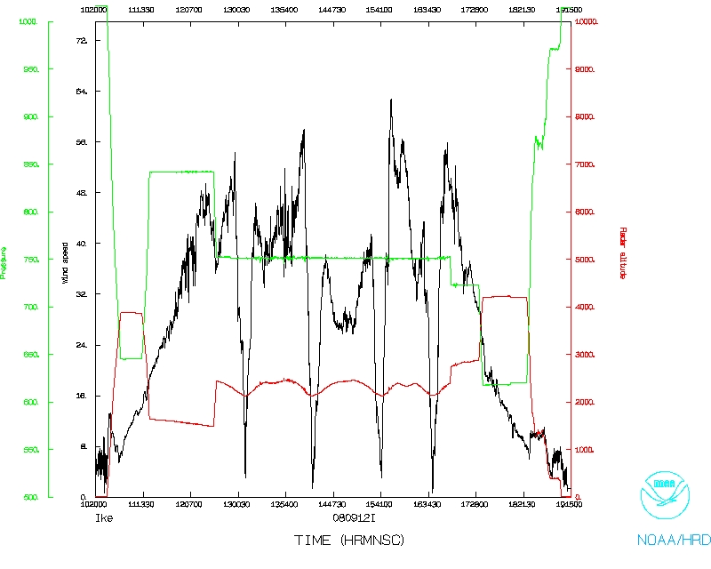
Mission Data :
Dropsonde plots
850 mb
925 mb
1000 mb
surface
Flight-level Data
NetCDF listing
1 second listing
Page last updated April 29, 2009
Return to Mission page.