Mission Summary
20080910N1 Aircraft 49RF
Ike Synoptic Surveillanceflight 2008
| Flight Director | Paul Flaherty |
| AVAPS | John Hill |
| Dropsonde Scientist | John Kaplan |
| Flight Director | Paul Flaherty |
| AVAPS | John Hill |
| Dropsonde Scientist | John Kaplan |
Mission Plan :
The G-IV jet, with HRD scientists John Kaplan, will fly a Synoptic Surveillance missions around Hurricane Ike. The jet will leave MacDill AFB, FL at 05:30 UTC and will recover at MacDill AFB, FL by 13:30 UTC.
|
Aircraft: N49RF Altitude: FL410-450 Proposed takeoff: 10/0530Z | |||
| DROP # | LAT (d m) | LON (d m) | TIME (h mm) |
| 1 | 29 00 | -80 00 | 0:22 |
| 2 | 27 00 | -79 00 | 0:40 |
| 3 | 25 45 | -82 00 | 1:05 |
| 4 | 24 00 | -80 00 | 1:26 |
| 5 | 23 27 | -82 26 | 1:46 |
| 6 | 21 10 | -83 18 | 2:06 |
| 7 | 21 05 | -84 26 | 2:15 |
| 8 | 21 05 | -85 46 | 2:25 |
| 9 | 21 43 | -86 53 | 2:35 |
| 10 | 22 42 | -87 48 | 2:46 |
| 11 | 24 00 | -88 06 | 2:57 |
| 12 | 23 00 | -90 00 | 3:14 |
| 13 | 24 00 | -91 00 | 3:26 |
| 14 | 25 00 | -92 00 | 3:37 |
| 15 | 26 00 | -93 00 | 3:48 |
| 16 | 27 30 | -94 15 | 4:04 |
| 17 | 28 30 | -92 30 | 4:19 |
| 18 | 28 30 | -90 00 | 4:39 |
| 19 | 27 15 | -91 45 | 4:56 |
| 20 | 26 00 | -91 00 | 5:07 |
| 21 | 25 00 | -90 00 | 5:19 |
| 22 | 27 00 | -89 00 | 5:37 |
| 23 | 25 18 | -87 48 | 5:53 |
| 24 | 26 21 | -86 58 | 6:04 |
| 25 | 26 55 | -85 46 | 6:15 |
| 26 | 28 00 | -87 00 | 6:28 |
| 27 | 29 45 | -87 45 | 6:43 |
| 28 | 28 30 | -84 00 | 7:13 |
| 29 | 26 55 | -84 26 | 7:27 |
| 30 | 26 21 | -83 14 | 7:37 |
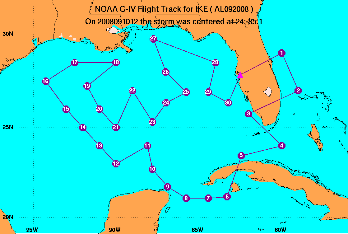
Mission Summary :
The mission was flown as planned and a total of 30 sondes were dropped and transmitted (see below).
Problems :
The sondes worked well and there were no significant problems encountered during the flight.
John Kaplan
Dec. 12, 2008
|
Aircraft: N49RF Altitude: FL410-450 Takeoff: 10/0530Z | ||||
| DROP # | LAT (d m) | LON (d m) | ELAPSED TIME (h mm) | COMMENTS |
| 1 | 28 54 | 80 00 | 0:22 | |
| 2 | 27 00 | 79 06 | 0:40 | |
| 3 | 25 42 | 81 54 | 1:05 | Winds missing 200-300 mb |
| 4 | 24 00 | 80 12 | 1:26 | |
| 5 | 23 24 | 82 24 | 1:46 | |
| 6 | 21 12 | 83 24 | 2:06 | |
| 7 | 21 06 | 84 30 | 2:15 | |
| 8 | 21 05 | 85 46 | 2:25 | No launch detect didn't hit sfc |
| 9 | 21 42 | 86 54 | 2:35 | |
| 10 | 22 36 | 87 42 | 2:46 | 200-400 mb bad winds |
| 11 | 23 54 | 88 12 | 2:57 | |
| 12 | 23 06 | 90 00 | 3:14 | Sent corrected obs |
| 13 | 24 00 | 91 00 | 3:26 | |
| 14 | 25 00 | 92 00 | 3:37 | |
| 15 | 26 00 | 93 00 | 3:48 | |
| 16 | 27 30 | 94 06 | 4:04 | |
| 17 | 28 30 | 92 30 | 4:19 | |
| 18 | 28 18 | 90 12 | 4:39 | |
| 19 | 27 12 | 91 42 | 4:56 | |
| 20 | 26 00 | 91 00 | 5:07 | |
| 21 | 25 06 | 90 00 | 5:19 | |
| 22 | 26 54 | 89 00 | 5:37 | |
| 23 | 25 24 | 87 42 | 5:53 | |
| 24 | 26 18 | 87 00 | 6:04 | |
| 25 | 27 00 | 85 54 | 6:15 | |
| 26 | 28 00 | 87 00 | 6:28 | |
| 27 | 29 42 | 87 36 | 6:43 | |
| 28 | 28 24 | 84 06 | 7:13 | |
| 29 | 26 54 | 84 24 | 7:27 | |
| 30 | 27 18 | 84 18 | 7:37 | |