![]()


| Staff | Data Center | Contact Information |
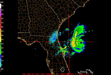
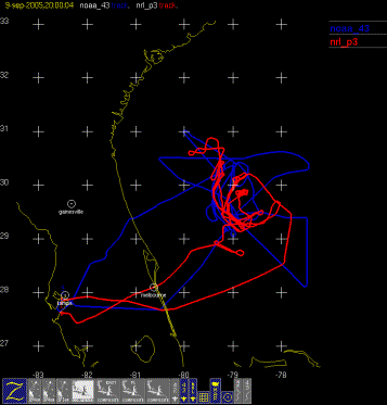
IFEX daily logFriday, September 9, 2005 Ophelia continues to linger off the east coast of Florida. Infrared satellite imagery (Fig. 102) shows that Ophelia is not experiencing as much shear as the previous day, but it is continuing to experience some southeasterly shear. This shear is confirmed by the CIMSS shear analysis product (Fig. 103). The eye of the storm is visible from Jacksonville radar (Fig. 104), which also shows a band of strong rain on the west side of the storm wrapping around to the southwest side. 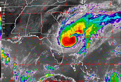 Figure 102. GOES-East infrared image valid 1830 UTC September 9, 2005. N43RF had a tasked mission today, with fix responsibilities at 12, 15, and 18 UTC. There is also a requirement for a figure-4 pattern to be flown at 5000 ft, with leg lengths of 105 nm. GPS sondes would be dropped for NHC at the center and at the RMW, while RAINEX sondes would be dropped at the turn points. At the end of the fix responsibility, N43RF would climb to 10,000 ft and begin a coordinated pattern with the NRL P-3 for a RAINEX rainband module. There was a possible band to target around the north and west side of the storm, as evident from the radar image (cf. Fig. 104). The actual pattern flown was similar to that planned (Fig. 105). The system was experiencing shear, and the pressure was lower than before, but the winds were not much higher. In between the second and third fix, N43RF flow along a rainband on the west and northwest side of the storm. N43RF flew two downwind and two upwind legs (Fig.
 Figure 103. CIMSS-derived 850-200 hPa vertical shear (shaded, kt) valid 09 UTC September 9, 2005.
106). It was outside the band, while the NRL P-3 was inside the band. After the third fix, N43RF set up for an upwind leg along the principal rain band on the west side. The aircraft tried to come back on the inner edge to follow down to its intersection with the eyewall, which would have made for a great set of observations for RAINEX. However, it was not deemed safe, so the pattern was abandoned. Overall, the mission was very good. N43RF accomplished its tasking objectives and found that the storm pressure had dropped while the wind speed had maintained constant strength. There was good coordination with the NRL P-3, with passes on opposite sides of two rainband features at two different times. On the first pass the rainband was within 10 km for much of the leg with N43RF. This close proximity should provide great Dual-Doppler coverage. This mission marked the end of the 12-h intervals for the NOAA P-3Ős being in the system, and thus marked the end of the 12-h portion of the Frequent-Monitoring experiment for this storm. There have been six missions in Ophelia in a three-day time period, each of them including radar and dropsonde observations and two of them including the NRL P-3 as well. 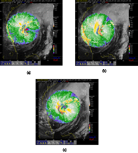 Figure 106. Plot of lower fuselage reflectivity (shaded, dBZ) from N43RF and flight tracks of N43RF and NRL P-3 during previous 30 minutes for (a) 1500 UTC; (b) 1530 UTC; and (c) 1800 UTC September 9, 2005 Rob Rogers |
![[OAR/DOC/NOAA Logos]](../../../oar_noaa_doc_logos3.jpg)