![]()


| Staff | Data Center | Contact Information |
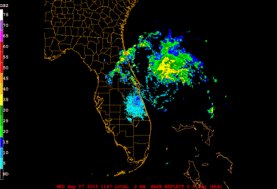
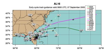
IFEX daily logWednesday, September 7, 2005 N43RF was tasked for a flight into T.D. #16, with fix responsibilities of 06, 09, and 12 UTC. Takeoff time would be at 0430 UTC on September 7. Since the original plan called for this pattern to be flown at 5000 ft, it was decided to piggyback a research mission onto this tasked mission. Because of the near 12-h staggering between missions, and the tasking of N42RF and N43RF on the following days, this would make an excellent 12-h Frequent Monitoring Experiment. The mission involving N43RF consisted of a rotating figure-4 pattern, with the initial point 105 nm northwest of the center. The first two passes would be flown at 1500 ft, and then the plane would climb to 5000 ft for the final pass. Sondes would be dropped only from 5000 ft, at the turn points and the midpoints of that radial leg. The tail radar would be run in F/AST mode for most of the pattern, except for the second half of the first inbound leg, when it was run in continuous mode. The system was getting better organized while N43RF was in there. The pressure dropped to 1003 hPa during the flight, it was hence upgraded to Tropical Storm Ophelia. Banding was evident of the north, east, and southeast sides of the storm. The center was still located south of the convection, but it may be repositioning itself further north. N43RF was able to fly some of a frequent-monitoring experiment. Because much of the pattern was flown at 1500 ft, there were no drops, but there was radar coverage, at least on the north side of the storm where there were scatterers. The aircraft did climb to 5000 ft and drops sondes south, at the midpoint, north, and on the final downwind leg. There was also some limited vertical incidence data, and cloud physics data. Tropical Storm Ophelia has slowly organized overnight. Satellite imagery indicates a broad shield of cold cloud tops (Fig. 95) with outflow inhibited to the south, indicative of some southerly shear impacting the system. A radar image from the Melbourne radar (Fig. 96) shows the shield of convection extending fairly far north. A band is also evident onshore in northern Florida. Track guidance for Ophelia (Fig. 97) shows a wide spread. Some dynamical models (e.g., the Canadian global model) take Ophelia out to sea, while other dynamical models, such as the GFDL, bring the system over land and into the Gulf of Mexico. Such a wide spread is indicative of considerable uncertainty. Both NOAA P-3Ős are still tasked for fix/SFMR missions into Ophelia, separated by 12-h frequency. The N42RF tasked mission will also have the NOAA Frequent Monitoring and Ocean Winds experiments piggy-backed onto it. As in the previous day, the plan called for a figure-4 pattern to be flown, this time at 5000 ft. The NRL P-3 would not accompany N42RF this time, however. 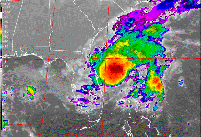 Figure 95. GOES-East infrared image valid 1115 UTC September 7 2005.
Rob Rogers |
![[OAR/DOC/NOAA Logos]](../../../oar_noaa_doc_logos3.jpg)